Peak Uchityel, in English Uchityel - is a medium-height summit.
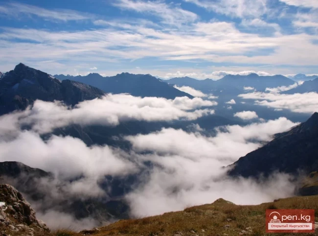
Geographically, the peak is located as follows: Eurasia (Asia), Siberia, Kuznetskiy Alatau. From an administrative point of view, the peak is located in Kyrgyzstan. It is situated on the watershed of the Ala-Archa ridge of the Kyrgyz Alatoo and is one of the most popular peaks among climbers from Bishkek in the Ala-Archa river basin.
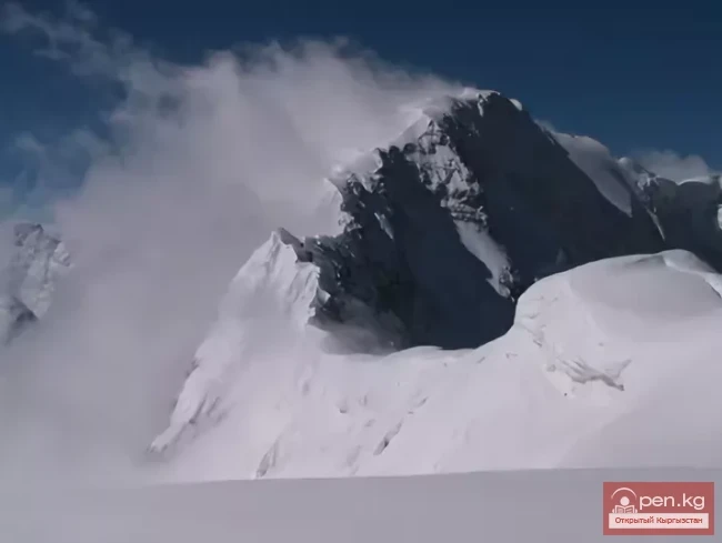
The mountain rises to four thousand five hundred seventy-two meters, or fifteen thousand feet.
This peak is known as the highest in category 1B across the entire territory of the former Soviet Union.
The best months for climbing the peak are July and August.
A peak of this level, like Uchityel, is more of a landmark than a climbing objective.
No technical training is required to ascend this peak. The entire route appears as a long steep ascent, which, nevertheless, will take enough strength from you to arrive in the evening tired but satisfied with yourself.
Take a thermos and sandwiches, check the weather forecast, and don’t forget a raincoat or poncho if necessary...
For professional climbers, there are more challenging routes.
Description of the climbing route to Peak Uchityel (4526.8 m.) Category 1B
The Ala-Archa ridge, dividing the basins of the Ala-Archa and Alamedin rivers, moves from Peak Baichchekey towards Peak Oleg Koshevoy, making a slight zigzag within Peak Uchityel, deviating a bit to the west. The eastern and northeastern slopes of the peak drop steeply towards Baichchekey (the source of the Chunkurchak river - the last left tributary of the Alamedin river) and are entirely covered by a glacier with seracs. The southwestern slope is complicated by several rocky buttresses, the northernmost of which, reaching the Aksai glacier near the Ratsek camp, makes a sharp turn to the north and ends at the Aksai waterfall, a considerable distance from the peak massif. By the end of summer, snow almost completely melts from this slope, leaving only a few small patches. All the buttresses of the peak
Uchityel are quite steep. The northern of the southwestern buttresses adjoins the watershed of the Ala-Archa ridge north of the summit (about 200 meters) and forms a ridge of minor steepness. Significant snow cornices hang from it to the east and northeast, ready to fall at any moment. Climbers need to keep this in mind.
Usually, the ascent to Peak Uchityel is made from the Ratsek camp, so this description does not include approaches.
Route
The ascent begins immediately from the Ratsek camp. Overcoming the moraine heaps and the broken rocks of pink granite on the southern slope of the western (let's conditionally call the northernmost of the southwestern) buttress, the group enters a couloir filled with debris, quite loose at the bottom but more reliable in the upper part of the couloir.
The slope is quite steep, but soon the climbers reach a snow-free rocky plateau. Once on the upper platforms of this plateau, climbers have the opportunity to see the entire route to the summit. There will be some time spent walking across the plateau, which in this place crowns the ridge of the western buttress, but then, when the ridge of the buttress begins to steepen again, it will be necessary to traverse right into a gully and ascend from it to the next, more southern buttress. It rises almost immediately. It is covered with debris, outcrops of broken granite rocks, and only above it, the ridge is crowned by 2-3 towers, which should be bypassed on the right side while moving, from the southern side, as there is snow on the northern side, under which there may be ice. The highest tower, resembling a black finger from below, rises about 3/4 of the height of the entire buttress. Behind this tower, almost to the summit, one has to walk on debris (to the summit ridge, and then along the ridge). Once again, we remind you that cornices hang from the summit ridge to the northeast, and one cannot step onto the visible line of the ridge. The tower is located at the highest point of the massif, and it will take only 9 hours of walking from the camp to reach it, and 5-6 hours from the Ratsek camp.
Descent via the ascent route. Only ropes and ice axes are required for the ascent.
The first ascent of the peak was made on May 26, 1948, by climbers B. Marechek and K. Marechek, leading a small group of students from the mountaineering instructor school.

Description of the traverse of the peaks Uchityel - Baichchekey (4526.7 - 4515) Category 2B
The traverse of the peaks Uchityel and Baichchekey begins immediately from the Aksai camp to the northeast along a steep grassy slope densely strewn with stones. After passing this section, the group reaches the moraine heaps, and continuing further, they come out onto a rocky plateau. Upon entering the summit area of this plateau, climbers have the opportunity to see the entire route to the summit. After traversing the rocky plateau, at its upper part, the ridge of the western buttress begins, consisting of broken rocks. The group reaches this gentle buttress.
To the right, there will be a couloir of debris, and even further right - a similar buttress. To the left, there will also be a couloir. Approximately halfway along the buttress, individual towers rise, which are easily bypassed: the 1st and 2nd to the left, and the 3rd and 4th to the right.
Where the towers end, a slope of minor steepness begins, extending for 150 meters. To the right, depending on the time of year, there may be a snowfield. At the upper part of this debris slope, broken rocks rise. The path passes to the right of these rocks. Keeping close to the rocks, the group enters a couloir formed by the two buttresses mentioned above. The couloir, 150-200 meters long, consists of loose rocks. After overcoming this section, the group reaches the saddle between Peak Oleg Koshevoy and Peak Uchityel.
Upon reaching the ridge, the group turns south and moves along an easy ridge. This ridge leads to the summit itself. We remind you that cornices hang from the summit ridge to the northeast, and one cannot step onto the visible line of the ridge. The tower is located at the highest point of the massif. Behind the summit, there are small towers that can be bypassed to the left while moving.
After several towers, there is a dip, and ahead rises a wall consisting of easy rocks.
It must be overcome head-on. The wall is approximately 15 meters high. In this dip, there is a snow overhang with a crest. It should be passed slightly below the ridge. From the upper point of this wall, a snowfield descends to the east. It is traversed with careful belaying, after which the group reaches dark-colored rocks.
The descent from the rocks leads to a saddle, which is closed off by a tower. It should be bypassed to the left. The saddle also has a snow overhang with a crest. It is overcome in the same way as the first. Beyond the tower, there is a dip leading to the Aksai pass. A tower is built at the pass.
From the pass, the group ascends through broken rocks to the pre-summit area. This area is the foot of the tower. The route to the tower of Peak Baichchekey goes through steep rocks with many holds.
The summit is a platform. The descent from the summit goes south and leads to a loose buttress with individual towers.
The towers can be easily bypassed to the left or right. The direction must be maintained towards a separate tooth on this buttress. From the tooth, one should turn right and descend straight down through the debris. Along this debris, the group descends to the "Science" camp, and from there, they proceed along the moraines to the Ratsek camp. When traversing, it is necessary to move in teams, providing protection through the ledges.