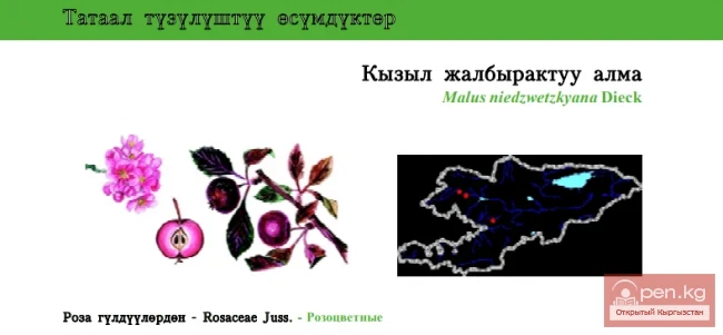
Chatkal Ridge of the Central Tien Shan
The mountain range in the Western Tien Shan, which limits the Fergana Valley from the northwest, is about 225 km long, 30 km wide, and has an average height (above sea level) of 3800 m. The highest peak, Chatkal (Aflatun), reaches 4503 m. It is located in the Tashkent region of Uzbekistan and the Jalal-Abad region of Kyrgyzstan. The main peaks of this ridge are slightly above 3000 meters, among which stand out Big Chimgan, Kyzylnura, Babaytag, Karakush, and Chatkal Peak, which is already located on the territory of Kyrgyzstan.
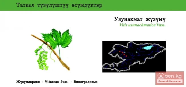
The Chatkal Ridge extends from the Talas Alatau at the sources of the rivers Karasu, Uzunakhmat, and Chatkal, and for almost 120 km forms the northern framing of the Fergana Valley. The southern slope of the ridge has a width from the ridge to the foot of 35-50 km, while the northern slope extends from the watershed ridge to the Chatkal River by 12-18 km. The drop of the valleys on the northern slope is steep, while the southern slope is more gentle. The river gorges cut through both slopes almost transversely. The exception is the latitudinal parts of the valleys of the upper tributaries of Chatkal (Karakulja, Aksu, Kаратоко) and the upper reaches of Kasansay.
Most valleys at the watershed ridge bear traces of ancient glaciation in the form of spurs, and snowless cirques are often observed. Small glaciers have survived at the sources of some rivers.
The eastern part of the Chatkal Ridge, crowned with a jagged, sharply defined ridge, has many isolated sharp peaks (the highest reaches 4563 m).
Traveling along the Chatkal Ridge from the Fergana Valley is conveniently started from the city of Namangan, which can be reached by train or plane. From here, regular buses will take tourists to the village of Karavan in two hours.
From Karavan, one can take a bus or hitch a ride to the point where the hiking part of the route begins.
The eastern border of the described area is formed by the Karasu River - a relatively large river that originates at the junction of the Chatkal and Atoynak ridges. Its river system is highly branched and includes many water-rich tributaries. We will only discuss the right tributaries, as the left ones begin outside the area of interest.

It is more convenient to traverse the Karasu Valley from the village of Abdukaly, which stretches along the river for several kilometers. Beyond the village, the trail goes along the left bank, crossing several tributaries of Karasu via bridges or fording. Here, the river cuts through limestone and conglomerates, causing the valley to narrow and take on the appearance of a deep gorge. Rocky, often sheer gray slopes are adjacent to fragments of terraces, sometimes covered with grand white debris descending from the Mıntake Mountain to the riverbed. In terms of the brightness of the colors of the floodplain vegetation and slopes, this section of the valley can be considered the most beautiful.
Above, the trail, sometimes descending to the water and sometimes moving away from it, crosses to the right bank and steeply ascends past a noisy stream that falls in cascades. The steepness of the ascent is explained by a huge landslide up to 200 m high, which once dammed the river. The dam formed a lake in the Karasu Valley, known by various names in different sources: Karakamysh, Kutemaldykul, Karasubashikul. Two kilometers from the dam in the river valley lies a small lake (at an altitude of 1700 m). The river flows calmly along the surface of the dam for 500 m to the lake. The banks are covered with spruce, maple, birch, creating a dense shade, with various shrubs and thickets of yellowish eremurus beneath the trees.
Just before the lake, the trail diverges: to the left - to the Kudarmaashu Pass and further to Lake Sarychelek; to the right - across the bridge to the eastern shore of Lake Karasubashikul.
The length of Karasubashikul is 1.5 km, width - up to 500 m, water level - 1870 m. On the eastern shore, in a place sheltered by rocks, there is a convenient camping site, shaded by huge maples, poplars, birches, and spruces. This shore can be followed to the northern end of the lake along a well-trodden path, which sometimes follows a ledge cut into the rocks, sometimes steep and slippery. The eastern shore is covered with tall spruces, while the opposite shore is bare and lifeless.
Above the lake, the river is called Okunsu (known locally as Kyzylsu). Here, the bottom of the valley resembles a wide glade with meadow vegetation, individual trees, and groups of birches and spruces.
The glade is formed by the delta deposits of the river, which has several arms before entering the lake.

The Okunsu flows calmly from the lake to its sources for about 15 km along a relatively wide riverbed, which must be forded from time to time: walking along one bank is hindered by marshy or stony sections right by the water. It takes about 4 hours to ascend the river to its left tributary Kashkasu.
Let’s ascend 2 km along the Okunsu, where the valley widens and several tributaries form a river. There is no information about crossing the passes of the Chatkal Ridge at the sources of Okunsu, however, pass saddles in the upper reaches of the Karatoko River (Chatkal basin) have been noted by many tourist groups.
Before the confluence of the tributaries of Okunsu, a small but relatively steep gorge resembling a bag descends from the right into the valley. In it, avalanche snow almost always lies at the bottom, under which the trail is hidden. Above, the trail calmly ascends to the ridge, to the Makmal Pass (2700 m, I A), then descends equally calmly to the river that feeds Lake Sarychelek.

Chatkal Reserves
Now let’s return to the mouth of Kashkasu, the left tributary of Okunsu. The height of the mouth is 2200 m. Along the short saiy, blocked by avalanches, we steeply ascend to the confluence of the two sources. From here, the trail turns right, towards the watershed between Kashkasu and the river Malatash, then climbs steeply up the ridge of the counterfort, passing through grassy slopes among thickets of prangos and ferula. Transitioning from the ridge to the slope, then back to the ridge of the counterfort, the trail almost disappears near the saddle. A rocky slope leads to the Kashkasu Pass, sometimes covered with compacted snow. The height of the pass is 3525 m, the difficulty category is I B.
We descend along the Kashkasu River, which flows almost north. Underfoot is debris material that has fallen from steep rocky sections. The gorge itself is filled with snow, alternating with green meadows and outcrops of gray rocks. The tiring descent without a trail (it appears from under the snow far below) leads to the confluence of Kashkasu with the Atoynak River, which flows southeast.
Here, it is necessary to cross Kashkasu by fording and ascend along the right bank of Atoynak amidst dense spruce forest. On the opposite bank, there is a high upland with good djailau. The Atoynak River is noisy but fordable everywhere.
By the milky color of the water, one can guess that it originates from under a glacier. And indeed, one of the tributaries of Atoynak - the Muztor River - begins under the glacier descending from the slopes of the same-named peak. In the area of this peak, there may be still unexplored passes to the upper part of the Chatkal basin.
Another tributary of Atoynak flows from the northwest and is called Karakulja. We need to go up it to reach the pass of the same name. Here, it is necessary to cross Muztor by fording and ascend along the right bank of Karakulja for about 4 hours. For some time, the trail stretches through the forest among picturesque rocks, then turns north and exits into a basin surrounded by high green slopes. This basin, where one can meet shepherds, lies 4-5 km from the pass, through which the caravan route from Talas and Chatkal to the Fergana Valley used to pass. Now the pass is only used by shepherds and tourists.
The stony, not steep, but prolonged trail leads into a typical steppe, heavily grazed by livestock. The saddle represents a flat surface with scattered stones. This is the Karakulja Pass (3120 m, I A). On the other side of the saddle is the same typical steppe, extending far down Karakulja, the source of Chatkal. The descent through the wide, sometimes marshy valley is relatively gentle. Below, one can find the yurts of shepherds.

10-12 km from the pass, a short tributary flows into Karakulja from the right, along the gorge of which the trail leads to the Chimitash Pass. Another 10 km, again to the right, the trail goes to the Akhtash Pass. Soon a dirt road appears; occasionally, trucks pass along it, delivering supplies to shepherds. About 1.5 km below Chimitash, the trail branches off, crosses to the left bank of Karakulja, and ascends to a low ridge that separates the valley of the latter from the valley of the Aksu River. This river originates from five glaciers, of which only two lie on the slopes of the main ridge. Leningrad tourists, ascending along the main channel of Aksu, bypassed the glacier and crossed the Aksu Pass (3450 m, I B), descending into the upper reaches of the Muztor River below the main cirque where the Bobrinsky glacier lies.
The Aksu Valley, where the trail crosses, is wide and relatively gentle, but its left bank, where the Kokuibel Pass (3036 m, I A) is located, is quite steep. From the pass, the trail passes a small spur and leads to the ridge, behind which flows the Karatoko River. The descent to its riverbed, although steep, is safe: the trail is well-trodden.
We will discuss the Karatoko Valley below. For now, let’s return to the basin of the Karasu River, or rather to the valley of its right tributary Khojaaty. The Khojaaty basin begins directly at the main ridge of the Chatkal Ridge (the highest point is 4247 m) and stretches almost 40 km with a width of 6-10 km. The upper part of the basin is mainly composed of limestones, which makes its relief dissected by deep valleys with steep slopes. In the lower zone, conglomerates of sandstones and marls prevail, so the slopes here are gentle, covered with a layer of soft soils.
By regular bus from Karavan, one can reach the village of Arkyt, where the office of the Sary-Chelek Reserve is located. Here, it is necessary to obtain permission to visit its territory.
The reserve was established in 1960. Its area is approximately 21,000 hectares. The length from north to south is 20-25 km, and the width is up to 12 km. In the upper part of the reserve, there are narrow, deep gorges, over which rise rocky sharp peaks. Among the steep, cliff-like slopes, there are snowfields. Alpine vegetation transitions to high grass meadows and shrubs as one descends, among which grow spruce, fir, juniper, and broadleaf trees. The lower part of the reserve is occupied by nut forests, alternating with thickets of shrubs. In total, the territory of the reserve counts almost a thousand species of plants.
The animal world is equally rich and diverse. Here, 41 species of mammals, 157 species of birds, 5 species of reptiles, 2 species of amphibians, and 5 species of fish have been recorded. Among large animals, one can mention wild boars, roe deer, bear cubs, lynxes, badgers, and porcupines. In the upper part of the reserve, mountain goats and rams, stoats, stone martens, snow leopards, and wolves inhabit the area. On rocky sections, one can see chukars and grouse, swallows, swifts, thrushes, and higher up - golden eagles, white-headed vultures, lammergeiers, griffons, and vultures.

The floodplains of the rivers, overgrown with forests and dense shrubs, are especially rich in birds. Cormorants, various ducks, herons, and ospreys inhabit the lakes. Among the fish in the rivers and lakes of the reserve, there are marinka, recently released carps, and Amudarya trout. On the shores of water bodies, one can find green toads, lake frogs, water snakes, and in the forest belt - patterned rat snakes and the only venomous snake of the reserve - the horned viper.
After an excursion through the territory of the reserve, we will continue our journey along the Chatkal Ridge. Above the last houses of the village of Arkyt, in Khojaaty, a fenced Tamanyaksay flows in from the right, where a bison nursery is located. On the northern slope of this saiy, there is a clean nut forest, with powerful trees almost closing their crowns.
Huge stones, entire cliffs that have fallen from above, give the gorge a picturesque appearance. Right by the water, there are squat birches with gnarled trunks. Higher up the gorge, the nut trees give way to apple trees, maples, and hawthorns, under which black currants grow.
Gradually, the gorge narrows to a canyon, and spruces appear on the cliffs. It is difficult to walk on the large and steep debris that fills the riverbed. Above the canyon, the valley widens, and a trail appears that serpentine ascends, bypassing the cliffs. During rains, the trail serves as a watercourse, but eventually, it leads to the Tamanyak Pass (3050 m, I A), located 10-12 km from Arkyt.

On the saiy leading to the valley of Aflatun, many trails converge, then merge into one on the left slope. At the bottom of the saiy is a snowfield formed by spring avalanches carrying stones and uprooted trees. Below the snowfield, the trail goes along a waterless riverbed and leads to the left bank of the Aflatun River.
The dirt road ascends along the Khojaaty River, then sharply turns right. If you continue along Khojaaty, you can bypass the Kichkel Pass (2552 m) and reach the northern end of Lake Sarychelek. In some sources, this pass bears the same name.
The road serpentine ascends to the counterfort, from the ridge of which Lake Kylakyl is visible. Its length is about 700 m, width from 200 to 400 m, and depth is insignificant. The gentle shores are overgrown with prangos, fruit trees, and sometimes juniper. Right by the shore, there is lush coastal vegetation (reeds, bulrush, sedge). On the southern shore of Kylakyl, the road diverges: to the right leads to the lakes Chachakul and Igrykyl, to the left - to Lake Sarychelek. From Arkyt to it is approximately 12 km.

Sarychelek
At the top of the dam, a water-filled mountain "corridor" stretches before your eyes, extending from the northwest to the southeast for almost 7 km. The maximum depth of Sarychelek is up to 245 m, the widest part (southwest) reaches almost 1.5 km, and the narrowest (middle) is 350 m. The surrounding mountains rise to 2600-2800 m. The water level in the lake is 1858 m.
The shores of Sarychelek are extraordinarily picturesque. Steep, often sheer cliffs plunge into the dark depths. Occasionally, the cliffs are replaced by debris, and then in the clear water, one can see almost every stone. On the slopes, mainly the northern ones, spruce, fir, and juniper form small forest masses. Closer to the water, especially in the valleys of tributaries, there are many birches. Trees fallen by avalanches are usually washed down to the southern shore.
Near Sarychelek, there are several small lakes. Kylakyl is already known to us. West of Sarychelek is Bakalykyl, southeast of it are Chukurkul, Chachakul, Kharamkul, and Igrykyl.
At Igrykyl begins the trail north to the Kudarmaash Pass. On the right (in the direction of travel), the watershed ridge rises, behind which flows the Karasu River. The landscape is very diverse: there is water, apple trees with honeysuckle, juniper, spruce, rocky debris, and open spaces overgrown with prangos and weeds. The ascent is relatively calm. One kilometer from the pass, another trail approaches the trail from Igrykyl, coming from the southern end of Sarychelek. It becomes harder to walk: the trail ascends along a stream that has washed out its bed. Feet slip on the water-polished stones. Here and there, logs are laid, and gravel is piled.
From Igrykyl to the pass is about 2 hours of walking, from Sarychelek - 0.5 hours more. Before the saddle, next to the trail, there are huge stones with arrows indicating the way to the Kudarmaash Pass (2460 m, I A). A well-trodden trail leads to the Karasu Valley, descending serpentine along the riverbed of the saiy. Bypassing a waterfall along the slope, the trail returns to the water, then climbs left to the counterfort, from where Lake Karasubashikul is already visible. From here, the trail steeply descends to the bridge over Karasu, which is about 1.5 hours of walking from the pass.

Now let’s turn to the northern end of Lake Sarychelek, where a river of the same name flows into it. Three of its streams, each flowing separately into the lake, run along a stony bed. They carry little water. The mouth of the river appears as a flat area covered with dense grass and scattered trees.
Next to the mouth of the river, a small saiy flows into it from the right, leading to the Sarychelek Pass. The ascent is prolonged but not difficult. Springs occasionally cross the trail. The meadows are covered with tall grass up to the waist. Spruces grow on the rocks. Higher up, subalpine vegetation rises to the pass at an altitude of 2820 m. Below, the lake is visible, with its eastern shores covered with spruces and meadows.
On the southern side of the pass, there are treeless slopes covered with prangos, among which the descent into the valley of Khojaaty begins.
The Sarychelek River itself narrows 1 km from the lake. Another right tributary, Kuldambes, flows from the west, while the main channel flows northward along a stony bed. The slopes turn into steep, sometimes sheer walls, occasionally interrupted by green meadows with spruces. Higher up, a left tributary flows into the river, from which one can ascend to the Makmal Pass. In the main valley at an altitude of 2200 - 2400 m, the first tongues of snowfields appear. Water flows from the rocks and slopes. There are sparse birches at the riverbed. The gorge narrows even more, the cliffs come closer, but the trail is well visible, although it often passes under the snow.
The gorge unexpectedly opens up, revealing a rocky cirque formed by the main ridge of the Chatkal Ridge and a spur that separates the upper reaches of Sarychelek and Aflatun. The mountains below are covered with juniper, higher up are grassy slopes, and even higher are sharply outlined bare rocks against the sky with ribbons of snow in the couloirs and cracks. In the left (in the direction of travel) corner of the cirque is the noticeable saddle of the Kuldambes Pass (2900 m, I A), which has a good trail. To the west, the trail goes over the stones to the Eastern Aflatun Pass. The river rushes down in turbulent cascades over huge stones. The ascent here is steep, first along the debris of the left bank, then along the snowfield of one of the side gorges, until the tourists ascend into the snow-filled cirque. Before the cirque, on the right (in the direction of travel), one can barely discern the couloir leading down from the Karatoko Pass, from the basin of the river of the same name. In the left source of the Sarychelek River lies a small glacier hidden under snow, covering an area of 0.25 sq. km, with no surface runoff into the river. The glacier is bypassed along the rocks on the right (in the direction of travel) while simultaneously ascending to the ridge and further descending to the Eastern Aflatun Pass (3340 m, I B). The tour in the lower part of the saddle may be closed by a snowfield, which has a wide steep tongue that descends into the gorge of the Aflatun River, which flows into Chatkal. The distance from Lake Sarychelek to the Eastern Pass is approximately 15 km.
From this pass, one must descend several kilometers along a steep snowfield, keeping to the left slope.
Far below, the trail appears. In places, it hides under the snow lying in the side tributaries, sometimes so steep that it is necessary to stomp steps. About 8 km from the pass, the trail descends to a flat area, next to which lie huge stones. One can camp on this flat area. The trail from the Middle Aflatun Pass also descends here. The road to it leads along Aflatun - the largest right tributary of Karasu. The Aflatun basin, at a distance of 15-18 km, directly adjoins the main ridge of the Chatkal Ridge, where the highest point reaches 4340 m. In the upper reaches of the river, four glaciers have survived, covering a total area of less than 1.5 sq. km.
From the village of Aflatun, a dirt road goes up the river; it bypasses the village of Shuduger (almost at the confluence of the right tributary Utyra into Aflatun), the forest farm Batra-khan, and slightly above the last one, it ends. Near Batra-khan, a small tributary Chelkandy approaches the main river from the right. Along its valley, the trail ascends to a small pass and goes into Utyr.
Above the forest farm, the trail stretches along the left bank of Aflatun and after 10 km approaches the mouth of the Oyalma River, while halfway to the right, a path leads to the Tamanyak Pass. At the confluence of Aflatun and Oyalma, a wide valley is covered with green meadows and spruce forest, and higher up, both gorges narrow. The left slope of the Oyalma Valley is gentler, with traces of landslides and mudslides, while the right is steep, covered with spruces. The trail runs almost all the time along the foaming river and only just before the Kuldambes Pass winds serpentine among grassy vegetation.
In the Aflatun gorge, as well as in Oyalma, the bottom and northern slope are covered with spruce forest, while the southern slope is overgrown with eremurus.
The limestones that form the gorge create steep walls. As one ascends, the gorge becomes more rocky, with boulders hanging overhead.
Closer to the pass, the slopes gradually flatten out, gaining softness. Here, grass grows among alpine vegetation, and higher up - along a rocky section. About a hundred meters from the saddle, the grass disappears, bare rocks appear, and at the very Aflatun Middle Pass (3364 m, I B), snow is possible. The descent along the northern slope of the Chatkal Ridge resembles the ascent in reverse order. First, there is a fairly gentle rocky slope. On the sides are cliffs of limestone. On the slopes, patches of creeping juniper appear. Below, the rocky slopes are replaced by gentler soft sections with patches of flowers.

Aflatun
Now the trail descends along the bottom of the gorge, crossing from one bank to the other over gravelly debris until it leads to the left bank of the Aflatun River, a tributary of Chatkal. The wild picturesque gorge seems impregnable from a distance. But this is just the first impression: along the riverbed, jumping from bank to bank, the trail stretches to the lake in the Aflatun Valley. But before describing this lake, let’s describe the last of the Aflatun passes - the Western one.
The way to it lies along the Utyr River (its length is about 25 km), which flows into Aflatun (southern) just above the village of Shuduger. The trail along the river is sometimes flooded with water, requiring crossings from bank to bank, sometimes fording, sometimes using bridges made of two or three logs. 15-17 km from Shuduger, the trail leads to the confluence of Utyr and Tuyukchi. By ascending along Utyr with a left turn (in the direction of travel), one can reach the upper reaches of the Itokar River. A complex pass called 30 years of TTTZ (Tashkent Tractor Plant) leads from Utyr to Kashkasu (the basin of Padshaaty), which is easier to cross from Kashkasu, as well as the pass of the Omsk tourists, which lies on the watershed of Tuyukchi and Kashkasu.
Near the mentioned confluence, a left tributary begins under the Western Aflatun Pass. A barely noticeable trail goes along the right bank of the tributary through a spruce forest, crosses to the debris of the left bank, then dives back into the forest, sometimes getting lost in tall grass. 1.5 km from the mouth, the gorge is blocked by a wall from which the river falls. The waterfall is bypassed on the left along a rocky couloir (insurance is mandatory). Higher up, the converging walls form a narrow gorge, after which a wide gentle valley opens up, filled with avalanche deposits.
Ahead, the jagged ridge is already visible. A gentle snowfield leads to the upper part of the gorge. To the left, a saddle appears, in its lower part steep fine debris, and above it, almost vertical rock sections up to 40 m high. The debris is overcome serpentine, the rocks pass under the wall with a subsequent exit to the ridge. Only then does the descent to the Western Aflatun Pass (3370 m, I B) follow.

From the saddle in the northeast, the peak known to tourists as "Castle of Fairy Tales" (4060 m) is visible. In the eastern corner of the cirque is the Sunny Pass, first crossed by Tashkent tourists and classified by them as II A (height 3620 m).
On the northern side of the Chatkal Ridge, below the cirque, a trail appears from under the snow, leading down the saiy. The valley is a trough stretched strictly north. The length of the saiy from the ridge to the lake is approximately 10 km. The lake was formed as the Aflatun River blocked the channel of the left tributary with its deposits. From the northern end of the lake, a tributary carries water into Aflatun along a stony riverbed.
The gorge here is widened. The river and its tributary flow along a flat area surrounded on all sides by high walls. On the steep cliffs, spruces and junipers cling. Below the Aflatun Lake, the river sharply turns northwest and squeezes through a narrow gap of smoothed limestones. The gap can be crossed knee-deep in water. Further, the gorge slightly widens, but still retains a wild character. Waterfalls cascade down from the cliffs above. Despite the rocky nature and steepness of the banks, the bottom of the gorge is covered with trees and shrubs. One has to move downstream for a long time until the trail begins to ascend the right slope, bypassing the narrowed section. Here, one of the trails continues down the river to Chatkal itself, while another ascends the right slope. Gentle and gradual, it forms a true plateau with magnificent grassy vegetation, where one can find shepherds' yurts and sheep pens. In the northwest, the ridge of the Sandalash Ridge is visible.
On the plateau, there are many branches from the main trail leading to Chatkal. The main trail, almost parallel to the ridge of the Chatkal Ridge, after passing through the deep valleys of the Taldybulak River and its tributary Tegereksay, sharply ascends to the Goluboy Pass (3100 m, I A), after which it descends into the valley of the Karatoko River. This same place is approached by a trail from the Kokuibel Pass.

The Karatoko Valley is very beautiful: terraces on both banks are overgrown with spruce, juniper, by the water - birch and shrubs. Higher up, the right slope drops off into cliffs, while the trail stretches along the left bank among Tien Shan spruces far from the water to descend to the riverbed near the confluence of the left tributary Ishenkul into Karatoko. Here, in the valley of the main river, a beautiful lake of debris origin, stretching from east to west for 650-700 m, is spread out.
In the Karatoko Valley, there are several small lakes, and 5-6 km from Goluboy, a huge stone dam is visible in the riverbed of the gorge, leading to the formation of the lake. Depending on the amount of water, the length of the lake ranges from 1.5 to 2.5 km with a width of about 500 m. The northern shore drops off into sheer cliffs, while the southern has steep debris that flattens out near the water. One can walk along the debris to the head of the lake, which is replenished by two tributaries.
The tributaries originate from glaciers on the northwestern slopes of the Chatkal Ridge.
Now let’s return to the mouth of the Ishenkul River. From here, an inconspicuous trail rises to a high dam, behind which are two roughly equal-sized small lakes. They are connected by a narrow strait that passes through high rocky "gates." From the lower lake, the trail steeply ascends the slope and goes about 6 km far from the riverbed.
The rocky canyon gradually expands into a trough-shaped valley with rich alpine vegetation. At the end of the valley, there is a cirque with a lake in the middle, filled with meltwater from a small hanging glacier. The ascent from the mouth of Ishenkul to the cirque takes 4 hours, and an additional 1.5 hours is needed to reach the ridge of the Chatkal Ridge.
From the cirque, the path lies over steep, heavily eroded rocks, where careful insurance is needed. The ridge of the ridge is sharp, with a small snow cornice. The tour on the right side of the saddle, from the side of Ishenkul. Tashkent tourists named the pass Kаратоко (3670 m, II A). The descent from the saddle "straight on" is impossible: the debris couloirs end in rocky drops. It is best to go right along the eroded rocks, then along a steep debris slope, across a snowfield, down a grassy slope, and again along debris that descends to the snowfield coming from the Eastern Aflatun Pass.

The Itokar River, a right tributary of Aflatun, does not approach directly to the main ridge of the Chatkal Ridge, but begins on the southwestern slopes of one of its spurs with a highest point of 4340 m. On the eastern slope of the highest part of the ridge, which limits the basin of this river from the northeast, there are two glaciers covering an area of 0.63 sq. km. Itokar flows into Aflatun at the village of the same name. A dirt road runs along the left bank of the river, bypassing the village of Itokar and several small villages that stand in the shade of fruit trees. Gradually, the valley narrows, the road often crosses from one bank to the other, and finally runs along the riverbed, as the cliffs have come close to almost 20 m.
Beyond these "gates," the valley immediately widens, and the road approaches a solidly built house of the forester on the right bank. In front of the house, Itokar receives its right tributary Babaatassay. Its valley is closed off by the peaks of Koksaray and Babaata. By bypassing insignificant passes near these peaks, one can reach the valley of Padshaaty.

Padsha-ata
In the valley of Itokar, the road has several branches to the djailau, where shepherds stand and from where they take milk and kumis. The road ends not far from the place where the valley narrows and the gorge begins. Here, on the right slope, there is a beautiful section with a spruce forest. The trail through the spruce forest leads to the ridge, and then along the left tributary of Jolbakana to the Padshaata River. From the upper reaches of Itokar, one can reach the sources of Utyr, Chettysay, and Kashkasu. The last two rivers already belong to the basin of Padshaaty.
Padshaata collects its waters from the southern slopes of the Chatkal Ridge, starting directly at its ridge, where the peaks rise more than 4300 m. The relatively high elevation of the ridge explains the presence of glaciers here covering a total area of almost 2 sq. km. The mountainous watershed zone of the river is predominantly composed of limestones, to a lesser extent sandstones, conglomerates, and slates, which creates many rock outcrops and debris slopes. In the upper part of the valleys of many tributaries, the riverbeds are blocked by loose rocky material, under which surface runoff is lost. The river itself belongs to the basin of the Syr Darya, but does not reach it, as it is diverted for irrigation.
5 km from Karavan lies the village of Nanai, near which is the "Koksaray" tourist base of the Namangan regional council for tourism and excursions. Bypassing the tourist base, the dirt road goes to the village of Karabashat. A road also approaches here, ascending along the right bank of Padshaata from Nanai. On the section between Nanai and Karabashat, the road crosses the right tributaries of Padshaata (Ulanbulak, Tostu, etc.). The upper reaches of these rivers approach the ridge behind which lies the basin of the Chanač River.
The road ends at the mazar of the "saint" Padshaata. From here, the walking part of the route begins. One needs to cross the bridge to the right bank of the river and, having ascended along it for about 500 m, stop in the shade of birches for rest.

Above the grove, the Padshaata valley sharply narrows, the cliffs come close to the water, stones fallen from the slopes block the river, causing the water to rush with a roar and splashes. This short gorge, only about a kilometer long, is locally known as Kapchugai. The trail along it stretches either along one bank or the other, everywhere over bridges, and sometimes over specially laid sections of logs. After 25 minutes of walking, the gorge opens up: here is the mouth of the left tributary - Jolbakana. 1 km from the mouth, Jolbakana bifurcates. Along the left tributary, one can go into the valley of Itokar, and at the sources of the main river - into the upper reaches of Itokar, but it seems that no one has passed here yet.
After 2 km, Padshaata receives the right tributary Mynzhilki, almost equal in volume to Padshaata. This confluence is located at an altitude of 1760 m. The trail here crosses over a bridge and bifurcates: to the left (in the direction of travel) - up Mynzhilki, to the right - along Padshaata. The floodplain and slopes of Padshaata are overgrown with spruce and fir, with birch and shrubs by the water. A well-trodden trail often crosses over bridges from one bank to another. Then, along the right bank, it steeply ascends, bypassing the gorges in the riverbed. Above the gorges, there is a bridge, from which the trail goes into the valley of Chettysay, where pass saddles to the sources of Itokar are possible. Near the mouth of Chettysay, the tents of cattle breeders stand.
Along Padshaata, the trail continues to ascend along the right bank. The river spreads across a wide valley in several streams and smoothly turns almost north. An hour and a half of walking from Chettysay, without sharp ascents, there is a large beautiful spruce grove where one can rest (at an altitude of 2095 m).
From here, it is only a 40-minute walk to the confluence of the Muztor and Kashkasu rivers, which form Padshaata. Above the confluence rises a prominent wall visible from afar, which ends at the water with a steep grassy slope overgrown with shrubs and huge spruces. The height here is approximately 2200 m. The sources of Padshaata are roughly equal in size and water volume.

From the confluence, Muztor flows northwest, while Kashkasu flows northeast. The relatively wide valley of Kashkasu creates the impression of an easy path through it, but this is only an illusion, as the slopes above converge and form difficult-to-navigate gorges, especially during high water. To reach the upper reaches of Kashkasu, it is necessary to exit into the Shaarsay gorge.
From the confluence of the rivers, the trail goes along the right bank of Muztor, immediately moving away from the water to bypass small gorges. At a distance of 2 km, Muztor must be forded three times, with the last ford located before the confluence of Shaarsay into Muztor. Here, the river is squeezed between two huge boulders, making the current quite strong.
Above the ford, the trail stretches up the Shaarsay gorge and disappears among the stones, through which the water flows. Here, one must calmly continue the ascent through the rocky gorge, which opens up at about 150-170 m, the slopes flatten out, and grassy vegetation appears. In the very gorge, a trail leads left to the counterfort that separates Shaarsay and Muztor.

Mynzhilki
The trail along Shaarsay winds along the left bank next to the rocky riverbed. Soon, the water runs away under the stones and only surfaces in certain places. From here, a smooth turn of the trail leads right to the slope, to a large flat area where shepherds usually settle (2860 m).
To the east, the saddle that needs to be crossed to enter the valley of Kashkasu is well visible.
After crossing this saddle (3308 m), the trail descends to the river, crossing numerous counterforts of the main ridge of the Chatkal Ridge. From above, the entire lower course of Kashkasu is visible up to its confluence with Muztor: 6 km from it, the trail descends. Here, the valley is wide, with gentle, vegetation-free slopes. The well-trodden trail smoothly ascends along the right bank of Kashkasu. The river does not receive large tributaries from the right, but several streams flow into it from the left, originating from small glaciers on the northern slope of the spur behind which lie the upper reaches of Itokar and Utyr.
The riverbed of Kashkasu becomes steeper, and snowfields appear: we have ascended to the very sources of the river. Here, a huge cirque with large snowfields, debris, and a glacier in the southeastern corner is present. Above the northern side of the cirque, peaks of 4369, 4235, and 4100 m loom, and south of the last one is the pass of the Omsk tourists. The peak of 4100 serves as a landmark, as above the cirque is divided by several counterforts. The exit to the pass of the Omsk tourists is not difficult ("sheep's heads," moraine, steep debris), but still takes about 2.5 - 3 hours. On the eastern side, the descent initially goes along debris into the cirque, lower down, until the river turns south (about 6 km) - in gorges, sometimes blocked by snow. In this section, the rather turbulent Tuyukchi River must be forded several times, descending next to small waterfalls, and sometimes it is even necessary to cut steps in a steep (up to 60 - 70°) snowfield. After the turn to the south, the Tuyukchi Valley widens, and tree vegetation, raspberry, and currant bushes appear. After 5-6 km, Tuyukchi merges with Utyr. The campsite of the shepherds we mentioned is located on the left side of the waterless rocky riverbed. Here, the trail rises about 1 km to turn left and go parallel to the ridge. From here, one can go up the riverbed and calmly ascend to the watershed with the basin of Kurusai in about 2.5 hours without a trail. In the upper reaches of this saiy, east of the pass, there is a glacier that feeds a small lake. The trail is visible far below. Crossing the watershed ridge can be classified as I B at a height of about 3600 m.

The trail crossing the rocky riverbed of Shaarsay goes about 100 m above the cliffs along the right slope of the saiy and gradually ascends parallel to the main ridge to one of the counterforts, which ends in rocky cliffs. Behind the next counterfort is a steep cliff, and deep below flows one of the tributaries of Shaarsay, which originates in the snowfields. Not reaching 40 m to the cliff, the poorly defined trail turns right, stretches along a debris couloir, crosses to another counterfort, and rises again along the couloir, where at an altitude of 3370 m, it passes a small spring. From here, another half hour of ascent along a rocky trail (in places it gets lost) leads to the Shaar Pass.
The height of the pass is 3600 m, difficulty I A, but in the presence of snow, it can be classified as I B.
The narrow saddle is covered with fine debris of a dirty gray color. A steep trail descends into the center of the cirque of the Kurpyrdy River. The bare slopes of the cirque are covered with fine debris. Far below, the riverbed is visible, along the right bank of which the trail runs.
And finally, the right source of Padshaata is the Muztor River. In the rocky gorge of Shaarsay, the trail goes to the counterfort that separates this saiy and Muztor. The opposite right bank of the river descends steeply to the water, and therefore the trail goes along the left bank, to cross the river in a ford after 1 km. Now the character of the banks has changed: on the left are steep walls and debris, while on the right, spruces and firs grow, among which the trail winds. The riverbed is blocked in many places by stones, forming many rapids and small waterfalls.
At an altitude of about 2700 m, the forest ends, and immediately there is a steep ascent serpentine along a large debris slope that stretches along the river for almost 1.5 km. In the widened part of the Muztor Valley, the river flows in several arms, while in the narrow, squeezed by rocks, it roars and foams. The trail, bypassing waterfalls and gorges, sometimes rises far from the water. It takes about two hours to reach the last djailau in the Muztor Valley from Shaar. Here, at an altitude of 3000 m, a small right tributary approaches the river, at the upper reaches of which is the Muztor-II Pass. To reach this pass, one must move along the left bank of the tributary for about two hours. 500 m before the ridge, the marked trail ends, but there are sheep trails, along which one can calmly ascend to the saddle (3490 m, I A). The descent leads to the upper part of the Mynzhilki basin.

The main riverbed of Muztor flows westward. At an altitude of 3100 - 3200 m, the first snow bridges appear; above them, the river runs through a groove washed in the bedrock. Here, the trail ends. It is better to ascend along the right bank.
Muztor flows out from under the left tongue of the glacier, the end of which is quite steep. Higher up, the glacier is gentle, and one can walk on it calmly, without fearing crevasses. The length of the glacier is 2.4 km, area - 1.2 sq. km, highest point - 3990 m, and the firn line is located at an altitude of 3810 m. On maps, the glacier is called Kengtor. It is closed off by high walls from the west and north, from which avalanches descend, feeding it. The entire glacier shifts towards the left bank, where there are many moraine deposits. On the left side, below the body of the glacier, there is a small lake. On the western slope above the glacier hangs a waterfall about 100 m wide and up to 250 m long. In the area of the waterfall, the body of the glacier gently turns north towards the foot of the peak of 4217 m. From the slopes of this and other peaks, stones are swept away by avalanches, covering almost the entire surface of the glacier.
To get acquainted with the upper reaches of Mynzhilki, one must return to the place where this river merges with Padshaata.
The marked trail goes along the left bank of Mynzhilki and crosses to the right bank over a bridge after 1 km. Before the bridge, there is a large flat area on the right where one can set up camp. Above the bridge, a saiy approaches from the right, which leads towards the Tostu River. Further, the trail crosses Mynzhilki many times, sometimes over bridges, sometimes by fording. The valley is very beautiful, full of greenery: spruce, fir, by the water - birch, blackberry bushes, and on the slopes - raspberry and black currant. One can encounter shepherds.
14-15 km from Padshaata, a beautiful waterfall about 30 m high is visible on the left. And just above it begins the Mynzhilki canyon. The rocky walls rise up to 500 m, narrowing to 10-15 m, and the water bubbles and foams. The riverbed is blocked by huge stones, among which the river carves its way.

Before the gorge, the trail turns right, ascends along a drying saiy, goes left after 2 km, and begins a prolonged ascent to the counterfort. To ascend almost 1000 m vertically, it is necessary to travel 5 km along a winding trail. The height of the Koshankar Pass, to which the trail leads, is almost 3200 m.
And immediately before your eyes, the sources of Mynzhilki open up. The upper part consists of numerous cirques that have carved the watershed ridge. From above, gorges can be seen stretching almost 2.5 km. Somewhere in the middle, a right tributary approaches them, flowing in a similarly impassable gorge. And only far below, where the valley slightly widens, the tents of shepherds are barely visible. The trail from the counterfort leads to these tents.

Kansai
The upper reaches of Mynzhilki border the sources of rivers (from west to east): Chanač, Aksu, Karagayly, and Muztor. The first three belong to the basin of Chatkal. There is no information about passes into the valleys of Chanač and Aksu. A one-way exit was made to the Mynzhilki Pass, which connects this river with the upper reaches of Karagayly. The estimated difficulty of the pass is I B at an altitude of about 3800 m. The northern, Chatkal side of the saddle is debris. To the right of the pass is a rocky ridge, which can be bypassed to avoid the steep slope. About 1 km from the saddle, a trail begins that descends to Chatkal.
If one goes east from the djailau along the saiy, it is possible to ascend to the Muztor-II Pass in 2.5 hours.
To the west of Padshaata, separated from it by a high spur, some peaks of which reach 4000 m, lies the basin of its right tributary - Chanač. In the lower part, the wide gravel riverbed of the river dries up, as it is intensively diverted for irrigation. The basin of Chanač begins at the main ridge of the Chatkal Ridge, where the altitude reaches up to 4100 m, and stretches more than 40 km in a narrow (3-6 km) strip to the southeast.
Like the basins of neighboring rivers, Chanač is composed of various mountain rocks; among them, limestones dominate in the upper half, while sandstones and conglomerates dominate in the lower half. About a third of the watershed zone is occupied by rock outcrops and gravelly debris. Only a small part of the basin is covered by forests, while the rest consists of sparse grassy cover in the lower reaches of the river and rocky slopes in the upper reaches.
A well-trodden trail ascends along the Chanač Valley, winding through a chaos of stones. Only in the upper reaches of the river can one find small snowfields that feed it.
About 3 km from the ridge, the trail bifurcates: the left leads to the Karaterak Pass, while the right leads to the Chanač Pass.

The Chanač Pass (3100 m, I A) connects two rivers of the same name. As one descends towards Chatkal, small bushes of creeping juniper appear, and the vegetation increases. The steep descent gradually flattens out, but here and there, one can see snow bridges under which the river flows. Huge boulders lie here and there.
The right bank descends steeply to the riverbed. In the upper part, it is composed of limestones, protruding with sharp teeth; below are sandstones that have formed whimsical pillars. These pillars and teeth give the gorge a wild appearance.
The valley expands and narrows, in wide places on gentle slopes covered with beautiful meadows, numerous flocks of sheep can be found. The trail goes along the bottom of the gorge, only occasionally ascending to bypass cliffs. On the slopes, there are many sheep trails, and almost all vegetation is trampled by livestock, which sharply contrasts with the bottom of the valley, densely overgrown with trees. Soon, Chanač flows into the Chatkal Valley.
The second pass from Chanač (southern) leads to the Karaterak River, which flows into Chatkal almost parallel to the previous river. The height of the Karaterak Pass is 3488 m, I A. The valley of the river is similar to that of the northern Chanač: steep right slopes without tributaries and gentler, softer left slopes divided by water-bearing saiy.
West of the Chanač Valley lies the central part of the Chatkal Ridge - a heavily dissected mountainous area with high relative and absolute heights. The average height of the ridge is 3500 m. However, the height of individual peaks decreases from 4236 m in the area of the Chanač Pass to 3200 m in the upper reaches of Kasansay and Akhangaran.
The direction of local watersheds is perpendicular to the direction of the ridge. Among the spurs, a high watershed stands out between the rivers Alabuka and Terek, crowned by a number of high peaks. From the southern end of this ridge, from the mountain Karakyr (3929 m), originates a major tributary of Kasansay - the Uryukty River. Here, it should be noted that all rivers starting on the southern slopes of the Chatkal Ridge, from Chanač to the Chapchama Pass, are left tributaries of Kasansay.
Therefore, a few words should be said about Kasansay itself. It begins at the junction of the Chatkal and Kuramin ridges, but unlike other rivers in the area, it flows almost parallel to the main ridge, from west to east, and further down - to the southeast.
In the Kasansay Valley, between the mouths of Alabuka and Uryukty, the Ortotokoy (Kasansay) reservoir was built back in 1947. About the same time, an improved road was built along the river, which leads through the Chapchama Pass into the Chatkal Valley. Trucks and passenger buses frequently travel this road, so it is easy to reach the mouths of all tributaries of Kasansay. Across the Chatkal Ridge, the section between the Karaterak and Chapchama passes has quite easy passes: Akhtash (3011 m, I A, winter), Kanyshkiya (3089 m, I A), Kanyshtor (3287 m, I A), Tillyaberdy, Tuzashu (3470 m, I A), Kochkorata (3275 m, I A), and finally, Chapchama (2808 m).
The Alabuka River flows into Kasansay from the left, 1.8 km below the reservoir. In the middle part of the valley, on its right slope, in the basin of the tributary Chalchisay lies the lake Akbaltirgan, covering an area of 0.1 sq. km. Geologists believe it was formed due to karst phenomena: there are many funnels and sinkholes in the area. The bluish water from the lake goes underground directly into the floodplain of Alabuka. There are many springs gushing from the ground in the basin of this tributary.

The Alabuka Valley is interesting for tourists due to ancient mineral extraction sites near the peak of Miskin, along the slopes of which the trail goes into the Chanač Valley. Another trail turns towards the tributary Chalchisay and goes along it into the valley of Uryukty - the next left tributary of Kasansay.
The Uryukty and Kainsu rivers originate on the southern spurs of the Chatkal Ridge, far from its ridge, so we will not stop on them, only mentioning them for orientation.
As one ascends, Kasansay approaches the ridge of the Chatkal Ridge more and more, causing its left tributaries to constantly decrease in both length and area of the watershed. While the length of the Terek River reaches almost 25-27 km, the length of Chapchama, the left tributary of Kasansay, is only 4-4.5 km. The overwhelming majority of rivers in their upper reaches have relatively gentle outlines, and rocky outcrops are almost invisible.
Many pass saddles in this area are used by shepherds when driving livestock from the Fergana Valley to Chatkal. It is not surprising that the passes here are not difficult. Thus, from the basin of Terek to the sources of the Chatkal tributary Karaterak, the Akhtash Pass at an altitude of 3011 m (I A, winter) leads. Nearby is the Kanyshkiya Pass (3089 m, I A), connecting the eponymous saiy with the Terek Valley. One can also reach Kanyshkiyasay from Terek through the Kanyshtor Pass (3287 m, I A), which is also called Kachalator. The eponymous saiy, flowing in different directions from the Chatkal Ridge, is connected by the Tillyaberdy Pass. The Tuzashu Pass (3470 m, I A) connects the left tributary of Kasansay Tuzashusai and the river Tuzashu, which flows into Chatkal.
By ascending along the Zensay Valley, then through the counterfort to the upper reaches of the Kochkorata River, one can reach the Chatkal Valley via the Kochkorata Pass (3275 m) or, along the right tributary of this river, through an unnamed saddle of approximately the same height.
And the road along Kasansay rises to the ridge of the Chatkal Ridge to reach the Chapchama Pass (2808 m) and then descend into the Chatkal Valley.