Mountains of Kyrgyzstan
Akshiyrak
A mountain range in the Tian Shan, located in Kyrgyzstan. It forms a watershed between the upper reaches of the Naryn River and the rivers of the Sary-Jaz basin. The range consists of three parallel ridges arranged in a culisiform manner, extending in a sublatitudinal direction. It is composed of metamorphic schists, limestones, and granites. The dominant landscapes are high-altitude – subnival and glacial-nival.

Akshiyrak is an important center of glaciation in the Tian Shan: the total area of glaciation is 439 km², with the largest glacier being Petrov Glacier, which is the source of the Naryn River.
Akshiyrak is a mountainous area of the Tian Shan, located south of the Terkey-Alatau ridge and separated from it by the valley of the Sarychat River. This river, after turning south, is called Irtysh, then changes its name to Uch-Kel and is a left tributary of the Sary-Jaz River. It separates Akshiyrak from the Kuilu mountain range to the east. To the south and west, Akshiyrak is bordered by the syrts (in Turkic languages, this word means "back") - large high-altitude plateaus. Their average height is 3600 m. Previously, a meteorological station operated on the syrts, but it is now closed. Near the former meteorological station building, there is a ranger's hut, and nearby is a checkpoint for access to the Kumtor development area.

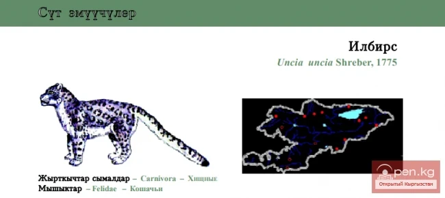
The syrts surrounding Akshiyrak are barren and have not been used for grazing for a long time. Encounters with people here are unlikely. Apparently for this reason, the number of animals inhabiting the syrts is large. We encountered many goats, and often found traces of predatory animals; according to the FGS ranger, wolves and snow leopards also inhabit the area.
Akshiyrak (highest point - 5150 m) consists of three closely spaced parallel ridges oriented from northeast to southwest and separated by large longitudinal valleys. Between the northern and middle ridges lies a deep longitudinal valley, in the western part of which is located the Petrov Glacier (14 km long, the third largest glacier of the former Soviet Tian Shan), while in the eastern part are the glaciers of the Jamansu River basin. The length of the Jamansu Glacier is over 10 km. Between the middle and southern ridges are glaciers: to the west is the Southern Karasai, and to the east is the Kainy (Koyandy, Koendu) (over 8 km long). The western part of the middle ridge is separated from the main massif by a large (over 10 km long) Northern Karasai Glacier. The total number of glaciers in the massif exceeds 130, with an area of glaciation of about 450 sq. km. The glacier tongues lie at altitudes of 3700-4100 m, with the snow line at 4100-4400 m depending on the slope exposure. It should be noted that the glaciers are relatively less fragmented, and there are no large icefalls here.

The relief of the inner part of the Akshiyrak massif has a typical alpine appearance - narrow rocky watersheds, steep walls, sharp peaks, and ridges. The latter, due to the steepness of the slopes, are often devoid of ice and firn cover, even if they rise above the snow line. Much of this can be explained by the absolute height of the area, as well as the fact that this mountain massif is composed of metamorphic schists, limestones, and granites.
Interestingly, however, despite the rocky terrain, almost all the challenging (up to category 3A difficulty) passes in the Akshiyrak massif are snow-ice. At the same time, there are many relatively simple passes that are still significant for route planning, categorized as 1B-2A. As for the peaks, it seems that climbers have plenty of options here, with routes for ascents available for every taste, including rock climbing. It should also be noted that from a climbing perspective, the Akshiyrak area is practically a blank spot.
The climate in Akshiyrak is harsher than in the Terkey-Alatau. The massif is almost entirely raised to an altitude of over 4 kilometers. The average annual temperature even on the syrts is -7 to -8 °C, which is lower than in the Pamirs or on Novaya Zemlya.
Only three months of the year have a positive average temperature, and there is not a single day without frost.
Even in July, there are frosts every night. After nighttime snowfalls, the entire surface of the syrts is covered with snow, which gradually melts during the day. Vegetation is extremely sparse: alpine meadows are found, and just above them are mosses and lichens. All of them grow above a layer of permafrost up to 300 m deep. In summer, the area becomes marshy.

The average daily temperature in the warmest month - July - in the area of the syrts is +4.7 °C, in August +3.0 °C. So it is not surprising that there are practically no trees, let alone shrubs here. Moreover, grassy clearings at altitudes above 4,000 m are also a rarity.
Not long ago, the Akshiyrak area was declared a nature reserve. However, wildlife is scarce here due to the harsh climate. Even rodents are almost absent; only mountain goats feel relatively comfortable, and even then only in the foothills bordering the syrts, where there is at least some grass. There are many goats, and soon, perhaps, snow leopards will follow them and settle in these mountains.
Ak-Shiyrak (in Kyrgyz, Ak-Shiyrak) is a phrase typically used in relation to sheep, meaning "white-legged".
Gissaro-Alai

A mountain system in Central Asia, part of the Pamir-Alai. The Gissaro-Alai is located to the west of the Pamir, between the Fergana Valley to the north, the Karshi Steppe, the Tajik Depression, and the Alai Valley to the south.
The eastern part of the system is located in Kyrgyzstan, the middle part in Tajikistan, and the western part in Uzbekistan.
The length of the Gissaro-Alai from west to east is about 900 km, with a width of up to 150 km in the western part and up to 80 km in the eastern part.
The highest point is 5621 m (Peak Skalisty in the Match Mountain Knot). Tectonically, the Gissaro-Alai is a folded structure of Hercynian age, composed of sedimentary and metamorphic rocks and granitoids. Known deposits of tungsten, molybdenum, arsenic, gold, mercury, antimony, coal, and sulfur.
The eastern part of the Gissaro-Alai comprises the Alai Ridge (with the northern ridges of Kichik-Alai and others), stretching west to the Match Mountain Knot. From here, the Turkestan, Zeravshan, and Gissar ridges extend, forming the western and middle parts of the Gissaro-Alai. The main ridges of these ranges and the highest (over 5000 m) leading chains are characterized by alpine relief (except for the Nura Tau ridge and the western sections of the Turkestan and Zeravshan ridges, where ancient erosion surfaces have been preserved). In the western part of the Gissaro-Alai, along the right bank of the Zeravshan River, are the mid-mountain ridges of Nura Tau (height 2169 m), Ak Tau (height 1993 m), and others; along the continuation of the Zeravshan ridge, on the left bank of the Zeravshan River, are low mountain massifs. At the northern foothills of the Gissaro-Alai, there are highly dissected loess foothills - adyres. Karst forms of relief are widespread: caves, gorges, and mines (including Boy-Bulok, Kan-i-Gut, Kyivskaya, Kap-Kutan, and others).

The characteristics of the subtropical continental climate of the Gissaro-Alai are determined by altitude zonation and uneven precipitation distribution. At an altitude of about 1500 m, the average temperatures in January are -7 °C, and in July 25 °C; at an altitude of about 3600 m, the average temperatures in January are -11 °C, and in July 13 °C. On the windward western and southwestern slopes, up to 2000 mm of precipitation falls annually, while on the leeward slopes, about 500 mm, and in some places less than 200 mm. The height of the snow line is 3400–4500 m.
The rivers mainly belong to the Zeravshan and Amu Darya basins. Picturesque mountain lakes include Iskanderkul, Marguzor, and others. High ridges and peaks are covered by glaciers (over 3800 m, total area about 2320 km²); the largest is the Zeravshan Glacier.

The landscapes of ephemeral and semi-ephemeral semi-deserts of the foothill plains and adyres are replaced in the mid-mountains by subtropical steppe, juniper scrub, and meadow steppes. In the western part of the Gissaro-Alai, forests of walnut, maple, and other broadleaf species are found.
In the high mountains, there are subalpine and alpine meadows, and on the peaks and ridges - glacial-nival landscapes, rocks, and screes. Within the Gissaro-Alai are reserves: Kitab, Gissar, Zamin, and Ramit; National Park of Uzbekistan.
Pamir-Alai

A mountain system in the southeast of Central Asia. Administratively located on the territory of Tajikistan, partially in Kyrgyzstan (northeast), Uzbekistan (west), and Turkmenistan (southwest); the eastern and partially southern edge extends into China and Afghanistan. Kyrgyzstan captures only the northernmost part of the Pamir - the northern slopes of the Zaalai ridge and the northern part of the Pamir-Alai, which includes the Turkestan and Alai ridges. In this part of the Pamir, the ridges have a latitudinal orientation.

Relief and Geological Structure. The northern ridges of the Pamir-Alai system are the Alai and Turkestan ridges, which border the Fergana Valley to the south. Both ridges are noticeably asymmetrical: their southern slopes are steep, while the northern ones are accompanied by leading chains (Kichik-Alai, i.e., Small Alai, and others). From the line of the Alai and Turkestan ridges in the area of the Match Mountain Knot (heights over 5600 m), the Zeravshan ridge extends westward south of the Zeravshan River. The Alai, Turkestan, and Zeravshan ridges carry numerous glaciers. These ridges are characterized by jagged crests, sharp peaks, and glacial landforms. Exceptions are the western sections of the Turkestan and Zeravshan ridges, which are mid-altitude and mostly flat-topped; here, due to lesser elevation, ancient erosion surfaces have been preserved. In the westernmost foothills of the northern chains of the Pamir-Alai system (Nura Tau ridge and others), ancient erosion surfaces are also traced, slightly elevated due to neotectonic movements and dissected by younger gorges. From the high glaciated crest of the Zeravshan ridge, a powerful Gissar ridge extends to the south.

The Climate of the Pamir is as sharply continental as that of the Tian Shan, but differs from the latter in relative weather stability, lower humidity, and a greater number of sunny days. The enormous range of altitudes, causing vertical climatic zonation, and sharp differences in moisture distribution, related to the directions of moisture-bearing air currents and orographic barriers, determine climatic contrasts. In the western part of the Pamir-Alai, on the Gissar ridge, up to 1500 mm or more of precipitation falls annually, and there grow forests of walnut and maple, while in the Eastern Pamir, only about 100 mm/year of precipitation falls, characterized by the most desert-like high-altitude landscapes. Maximum cloudiness, as in the Tian Shan, occurs in March-April, and minimum in August-September.
In the foothills of the Pamir-Alai and in the low mountains, winter is relatively short and mild, summer is long, with high temperatures; the amount of precipitation is greater than in the neighboring deserts (350—700 mm/year). At altitudes of 1500—3500 m, the climate already has characteristic features of a mountain climate, it is cooler and, in most of the territory, more humid: in these altitudinal ranges is the zone of greatest moisture, and in some places, precipitation exceeds 1000 and even 1600 mm/year. In the Eastern Pamir, the climate is very dry, sharply continental, and harsh (at an altitude of about 4000 m, the average temperature in January is up to -20°, in July 8°). In the valleys of the Western Pamir, temperatures are higher (at an altitude of about 2100 m, the average temperature in January is -7.4°, in July 22.5°), and although not as dry as in the Eastern Pamir, it is still very dry (annual precipitation is less than 260 mm); in the high mountains of the Western Pamir, precipitation is much greater, especially in the north.
The mountains of the Pamir are composed of metamorphic, igneous, and sedimentary rocks. Usually, the axial parts of the ridges are represented by igneous rocks, which are replaced by metamorphic and then sedimentary rocks towards the periphery.

Vegetation and Soils. Altitudinal Landscape Zones. The overall background of altitudinal zonality of vegetation cover is significantly influenced by the slope exposure and the general significant increase in climate continentality from west to east.
The influence of exposure is well illustrated by the example of the Turkestan ridge. On its northern slope (as well as on the northern slope of the Alai ridge), juniper forests of Juniperus semiglobosa (at lower altitudes - J. seravschanica) grow, while the southern slope is extremely poor in vegetation, with bare rocks and stony screes covered by dark desert tanning.
In the western part of the system, the structure of altitudinal zonality is almost the same as in the southern part of the Western Tian Shan, except that coniferous forests are absent here. The lower zone is formed by semi-deserts or desert steppes of subtropical type, dominated by ephemeral grasses ("low-grass semi-savannas") on ordinary (typical) and dark chernozems. The next zone consists of large-grain ephemeral subtropical steppes ("semi-savannas") on dark gray dry-steppe soils (leached chernozems). In the mid-mountains, where moisture is better, a forest-meadow-steppe zone is developed. The lower part of this zone is characterized by meadow steppes, shrub thickets, and broadleaf forests of walnut, maple, etc. Under the shrub thickets and forests, mountain-forest brown and brown soils are developed. In the upper belt, juniper thickets are widespread on mountain brown-brown soils. Broadleaf forests are most abundant on the Gissar ridge. The crests of high ridges belong to the mountain-meadow zone, with subalpine, alpine, and subnival belts, often with sparse and fragmented vegetation cover, and to the glacial-nival zone.

The Fauna of the Pamir, especially the high-altitude deserts of its eastern part, is not rich, but peculiar and has much in common with Tibet and the syrts of the Tian Shan. The Pamir is home to the mountain ram argali, the long-tailed marmot (Marmota caudata), the red pika, and the Pamir hare (Lepus tolai tibetanus). The domestic animal is the yak (kutus). Among the birds are the Tibetan grouse (Tetraogallus tibetanus), Tibetan sandgrouse (Tchangtangia tibetana), the serin, the Tibetan raven, the Tibetan lark, the brown-headed gull, the snow vulture (Gyps himalayensis), the mountain or Indian goose (Anser indicus), and the stonechats.
In the other mountains of the Pamir-Alai and partly in the Western Pamir, the mountain and screw-horned goats (Capra sibirica, C. falconeri), the mountain Central Asian fox, bear, Tibetan wolf (Canis lupus laniger), jackal, porcupine, mountain voles, and forest mice are common. Among the birds in the high-altitude zone, vultures are common, and in the mountain gorges - chukars (Alectoris kakelik), pigeons. Among reptiles, there are the horned viper and lizards.
Tian Shan

A mountain system located in Central Asia across four countries: Kyrgyzstan, China (Xinjiang Uygur Autonomous Region), Kazakhstan, and Uzbekistan. It is one of the most powerful mountain systems in Asia.
Its length in the latitudinal direction is about 2000 km, and its width is about 400 km. About 2/3 of the area of the Tian Shan mountains is located in Kyrgyzstan. The ridges of the Tian Shan have latitudinal and sublatitudinal extensions. They are composed of sedimentary, metamorphic, and volcanic rocks.

Orography. The Tian Shan is usually divided into the Northern, Western, Central, Inner, and Eastern Tian Shan based on orographic structure. The Northern Tian Shan includes the Kyrgyz, Zailiyskiy, and Kunghei Ala-Tuu ridges. The Central Tian Shan includes the eastern part of the Terkey Ala-Tuu and Kokshaalsky ridges, the Sary-Jaz, Tengri-Tag, Meridional, Inylchek, and Kainy ridges. The Western Tian Shan includes the Talas, Pskem, Ugam, Sandalash, and Chatkal ridges. The Inner Tian Shan lies within the boundaries - south of the Kyrgyz and Terkey ridges, east of the Fergana ridge, north of the Kokshaalsky ridge, and west of the meridional part of the Sary-Jaz River. The Eastern Tian Shan is located in China, east of the Meridional ridge. The ridges of the Tian Shan have a sublatitudinal extension, and only a few ridges have a different direction. These are the Fergana and Atoynok ridges, which stretch from the northwest to the southeast, the Meridional ridge, which has a meridional extension, and the ridges of the Western Tian Shan - Pskem, Ugam, Chatkal, and Sandalash, which extend from the southwest to the northeast. Most of the ridges have a typical mountain-glacial "alpine" relief. There is a slight distribution of highly elevated ancient leveled surfaces - peneplains, similar to Tibet, such as on the southern slope of the Terkey Ala-Tuu ridge or in the Inner Tian Shan, where they are raised to heights of 4-5 thousand meters. The climate of the Tian Shan is sharply continental: hot summers in the foothills and valleys and cool and cold in the high-altitude zone, harsh winters for these latitudes, large daily and annual temperature fluctuations, low cloudiness, and significant air dryness. There is a lot of sunshine, with an average annual duration of sunshine of 2500-2700 hours.

Maximum cloudiness occurs in March-April, and minimum in August-September. The vertical temperature gradient - the drop in temperature for every 100 m of ascent is 0.7°C in summer, 0.6°C in autumn and spring, and 0.5°C in winter. The amount of precipitation is very uneven and ranges from 200-300 to 1600 mm/year. The maximum precipitation occurs in the first half of summer. A special microclimate of the Tian Shan mountains is formed in the surrounding ridges of Lake Issyk-Kul. The relief, climatic features, boundaries of the snow line, vegetation, and wildlife of individual regions of the Tian Shan vary greatly. The total area of glaciers in the Kyrgyz part of the Tian Shan is about 6580 km², which constitutes almost 3.65% of the total area of the Republic. There are about 700 large and small glaciers here. A large share of glaciation in the Kyrgyz Tian Shan is concentrated in the eastern part - the areas of the Central Tian Shan and the Terkey, Akshiyrak, Kuilu, and Western Kokshaaltoo ridges. The largest of them, the Southern Inylchek Glacier, is 62 kilometers long. In terms of length, among mountain-valley glaciers, it ranks third in the world after the Baltoro Glacier (Karakoram) in Pakistan and the Fedchenko Glacier (Pamir) in Tajikistan. The maximum width of this glacier reaches three kilometers, and the thickness of the ice reaches two hundred meters.