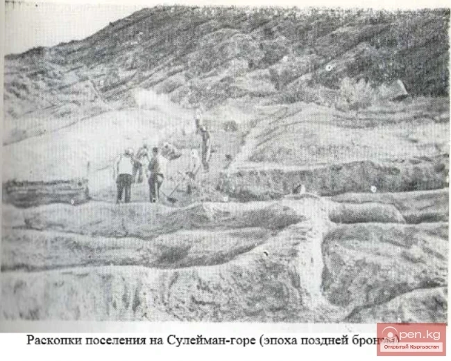
Archives of Unknown Documents on the History of Osh Having become a prominent Kokand dignitary, Datka Alay, the hakim of the Andijan province, and finally, for a short time, the chief vizier of the Kokand Khanate, Alymbek continued to regard the Alay pastures almost as his ancestral estate, while the city of Osh became the base for the Kyrgyz nomads. It was in Osh that Alymbek built a madrasah at his own expense, which, according to contemporaries, rivaled the khan's madrasah in Kokand in
The Transfer of Land Relations Practices from the Kokand Khanate to Southern Kyrgyzstan The majority of Osh's residents were engaged in agriculture, many in transportation and trade, and a significant portion in crafts. The branches of agricultural production remained traditional from the late 18th century until 1875: irrigated farming ("the city is surrounded by fertile land," "the fields are watered by canals," reported Murtaza Faizulin and other informants of G. F.
Stories of Individual Traders and Other Russian People about Osh Documentary sources from the time of Kyrgyzstan's dependence on the feudal despotic Kokand Khanate, both Kokand and Russian, contain very few factual and reliable details for describing the city of Osh, as well as other settlements in Eastern Fergana. However, from the sparse accounts of individual traders and other Russian people — "involuntary travelers," like F. Efremov, notes sent to Kokand by representatives
The Emir of Bukhara Appoints Kurbandzhan as Datka — Ruler of Alay After the death of Alymbek, political power and the leadership of the clan were inherited by his widow, Kurbandzhan-datka. In 1862, Khudoyar Khan, with the help of the Bukharan army, once again occupied Kokand and seized the throne. However, the eastern regions of Fergana, the Kyrgyz and Kipchaks, remained the most rebellious. A Bukharan detachment sent by Emir Muzaffar reached Osh and besieged the fortress of Mady. There is a
Alymbek — ruler of Alai. The city of Osh and the village of Kara-Suu were considered by the southern Kyrgyz feudal lords as their own stronghold. Here they owned real estate, and through Osh maintained contact with the Kokand governors and the central authorities of the khanate. The largest feudal lords who left a significant mark in the history of the city were Alymbek-datka and his wife Kurbandzhan, who outlived him by almost half a century. Therefore, we will briefly focus on their
In the Struggle Against the Kokand Rulers Starting from the 1760s, the rulers of the Kokand feudal domain (later a khanate), seeking to expand its territory at the expense of southern Kyrgyz lands, turned their greedy eyes towards the city of Osh. Even at that time, Osh played a significant role in the political history of the Kokand Khanate. Narrative sources briefly mention that its ruler was the feudal lord Hadji-biy, considered the head of the large Kyrgyz clan Adygene within the tribe of
Osh at the End of the 17th — Beginning of the 18th Century In 1638, Abdallah Khan seized supreme power in Moghulistan (with its center in Yarkand) and, in order to strengthen his position in the state, decided to conquer the neighboring mountainous regions of Kyrgyzstan adjacent to Eastern Turkestan. After campaigns to Pamir (in Bolor and Badakhshan), Abdallah Khan directed his troops to raid the city of Osh. The Kyrgyz successfully repelled the invasion twice but were soon forced to surrender
A First-Class Source — "Babur-nama". The author of these notes (memoirs), Zahir al-Din Muhammad Babur (1483—1530), was one of the representatives of the Timurid dynasty, who tasted the sweetness of power in Andijan, then the bitterness of exile, and finally became a fortunate conqueror and the founder of the vast Mughal Empire, which included India and Afghanistan. However, it was not for his military exploits and conquests that the Timurid heir was celebrated; UNESCO recognized the
In the early 15th century, Osh is mentioned in eastern chronicles in connection with the campaign of Timur's grandson — Ulugh Beg against the Ferghana ruler Ahmed. Driven out of Ferghana by Ulugh Beg, Emir Ahmed returned with an army obtained from the Mongols and, after Ulugh Beg left with his main forces, defeated the troops he had left behind at Osh. Later mentions of the city can be found in "Tarikh-i Rashidi" — the chronicle of Rashid's history by Mirza Muhammad Haidar,
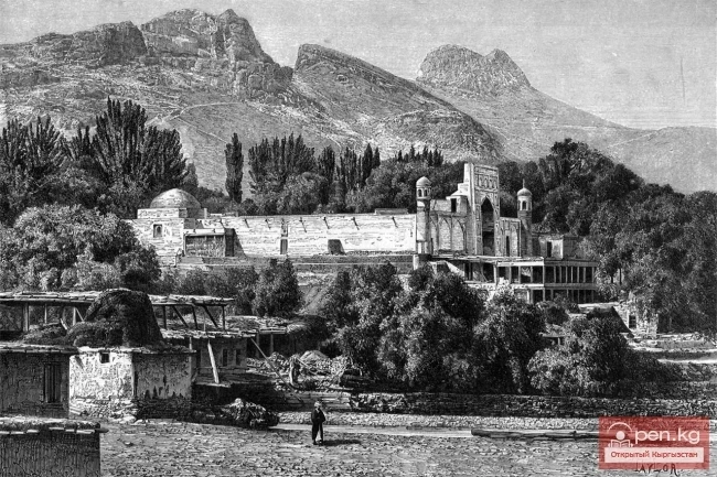
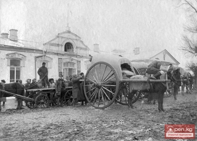
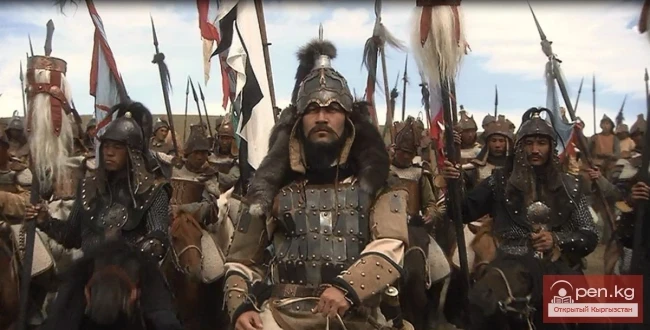
The Influence of Mongol Rule All the devastating hordes of Genghis Khan's army played their negative role in the life of the Fergana Valley and Eastern ("Kyrgyz") Pre-Fergana. The number of cities and settlements significantly decreased after their invasion in the early 13th century. If Arabic-speaking authors of the 9th to 12th centuries counted 40 Fergana cities (including Osh) and large settlements with congregational mosques, then by the 15th century, sources mention fewer
By the end of the 9th and in the 10th century, Osh already occupied a prominent place among the cities and large settlements of Eastern Fergana. Contemporaries considered it the third largest city in the Fergana domain of the Samanids — after the capital city of Ahsikent and the large (in size) city of Kuba (now Kuva). Rabad, like in other Fergana cities of the 9th—12th centuries, was the center of trade and craft activity in Osh. Pottery production held a leading position in the urban crafts,
First Mentions of Osh Osh is mentioned as a "city" of Fergana by the first Arab geographer whose works have survived to this day — Abul-Qasim Khordadbeh (820—912/13 AD). In his "Book of Roads and Kingdoms," compiled in 232 AH (846/47), it is reported: from the city of Osh to Uzgen (Uzgend — in medieval authors) is seven farsakhs or one long journey (1 farsakh equals 6—7 km). Following him, another Arab geographer Abu-Bakr Ishaq al-Hamadani (nicknamed Ibn al-Faqih) — the
In the Darkness of the Ages The more scholars refer to the works of the founder of scientific archaeology in Kyrgyzstan, A. N. Bernshtam, the more they are amazed by his "foresight," his retrospective insight. With only exploratory materials and relatively scant specific data, he managed to largely reconstruct the archaeological past of the Tian Shan, Fergana, and Pamir-Alai regions accurately. His periodization and the stages of their culture retain their scientific significance to
It is known that the Bronze Age in Fergana was universally replaced by the time of the dominance of early nomads — the Saka-Haomavarka.A vivid testament to the presence of the latter in the vicinity of Osh is the burial ground of Tuleyken, which was partially studied by A.N. Bernshtein. This is one of the connecting links between the Chust culture and the Davan kingdom — one of the ancient slaveholding states in the Fergana Valley. In the suburban areas of modern Osh (in particular, on the
Productive Work of Yu.A. Zadneprovsky and E.V. Druzhinina The city of Osh is undoubtedly the oldest in Kyrgyzstan and one of the ancient urban centers of Central Asia. Its written history spans over a millennium, while archaeological finds date back to three millennia ago. However, the question of the time of the city's founding remains open in scientific literature. There have been no specific excavations of the ancient substratum of modern Osh (including its former old town part)
Legends of Mount Takhte-Suleiman Osh ... Debating the etymology of this name, scholars still cannot reach a consensus — its roots go back so far into the depths of centuries. Equally ancient is its centuries-old history, intertwined with legends about the famous Mount Takhte-Suleiman (translated from Arabic as "Throne of Solomon").
Osh — the regional center of the republic, the oldest city in Kyrgyzstan. Through publications of archaeological excavations and written sources, readers will become acquainted with the ancient settlements in the territory of Osh and the medieval city, witnessing the turbulent events of the restless feudal era, the participation of the townspeople in repelling invasions by conquerors, and the uprisings of the Kyrgyz population against the khanate-feudal oppression during the dominance of the
The city of Shopokov is located at the northern slope of the Kyrgyz Range at an altitude of 740 meters above sea level. The terrain is flat. The city is situated 20 km west of Bishkek, with the international airport located 38 kilometers away. The largest enterprises in the city include a factory for producing technological equipment for the food industry and a sugar plant.
Orlovka — a city in the Kemin District of the Kyrgyz Republic. The status of a city was granted to the urban-type settlement of Orlovka on September 27, 2012. It is located on the northern slope of the Kyrgyz Range, 9 km from the railway station of Bystrovka (on the line from Bishkek (Frunze) to Balikchy (Rybachye)). The population is 5,700 (2017). Its highest point is 1,160 meters above sea level. The length of Orlovka from south to north is 3.0 kilometers, and from west to east — 3.3 km. The
The city of Nookat is located in Kyrgyzstan and is the center of the eponymous district of the Osh region. It lies in the northeast of the Osh region, 43 kilometers from the city of Osh, where the nearest railway station is located. The airport is also situated in the central regional city of Osh. A road runs through the territory of Nookat in the direction of Osh-Batken-Isfana. Population (2017) — 15,921 people.
City of Kök-Jangak (Kyrgyz: Көк-Жаңгак) — a city of regional subordination in the Jalal-Abad region of the Kyrgyz Republic. Population (2017) — 10.2 thousand people.
The city of Kerben is located in the center of the Aksy district, at an altitude of 1200 meters above sea level. The city is located to the northwest of the regional center, the city of Jalal-Abad, at a distance of 220 km, and 60 km from the railway of the city of Tash-Kumyr. The terrain is flat and hilly. The climate is continental. Winters can be harsh, summers are hot, with an average annual temperature of plus 12 degrees Celsius. History. The village was established in 1930 under the name
The city of Kara-Suu serves as the administrative center of the district of the same name. It was founded as a settlement near transport lines - the Osh - Jalal-Abad highway and the railway. The distance to the capital of Kyrgyzstan is 650 km, and to the nearest airport in the city of Osh — 22 km. The closest airport is located 24 kilometers away. The city limits are crossed by the Bishkek – Urumqi highway of interregional significance and the railway mainline connecting Europe, the CIS
From the settlement Molotovsky - to the city of Kainды The city of Kainды is located not far from the international highway connecting Almaty with Termez. It is 77 kilometers away from Bishkek. It was granted city status in 2012. Previously, it was called Molotovsky, during the time when it was a small settlement similar to those in the region. Within the city, there is a railway station serving passengers on the Bishkek – Chaldovar line. The length of Kainды from south to north is 6.6
Kadamjay - "Holy Place". The emergence of the city of Kadamjay is linked to the beginning of construction in this area of the antimony plant in the metalworkers' settlement in the 1930s. By 1941, it received the official name Frunze and the status of an urban settlement. In 1992, it was given its current name, which means "holy place." In 2012, Kadamjay became a city and absorbed surrounding settlements, including the district center, the village of Pulgon. Kadamjay is
Isfana— a small town located on the outskirts of the western part of the Batken region in southern Kyrgyzstan. Isfana is situated in the southern part of the Fergana Valley, in a region surrounded on three sides by Tajikistan. According to some sources, the word "Isfana" comes from the Sogdian word "aspanakent," meaning "land of horses." It is believed that the word "Isfana" originates from the Sogdian words "asbanikat," "asbanikent,"
Aydarken – a small town and industrial center in the central part of the Batken region. The population is 9,926 people (2017). It is located in a mountain plain basin (at an altitude of about 2000 meters), formed by one of the tributaries of the Ak-Suu River. The basin is surrounded by the mountains of the Alai Ridge. A road leads to Aydarken from the Fergana Valley, continuing towards Kanibadam. The district center is located 45 kilometers east of Aydarken. The town grew on the site of the
IN MEMORY OF THE POET-FRONTLINE SOLDIER TURUSBEKOV The street stretches from the railway line to Leningradskaya. There are still many one-story residential houses on it, but gradually the traces of old Pishpek are fading into the past. Whole blocks of old houses are being demolished. Here and there, multi-story buildings are rising. Especially intensively in recent years, the blocks from the railway line to Kirova Street have been developed. Here, the street is increasingly taking on modern
THIS IS WHERE "DUNGANOVKA" BEGAN The street stretches from north to south from the Big Chui Canal to the railway line. Until 1924, it was named Georgievskaya, then it became Pushkinskaya. In 1938, it was renamed and received the name Molotov, and since 1957 it has been called 40 Years of October. Most of the street is lined with one-story residential houses. If you look closely at them, you can see signs of former blind, windowless, adobe Dungan houses, which have now been remodeled
FROM ZAVODSKAYA TO BEISHENALIEVA The appearance and name of the former Zavodskaya Street are associated with the years 1921-1923. During these years, the street began to be developed, and it was named so because it passed by the brewery, which now occupies an entire block. It stretches from the Ala-Archa River to Ryskulov Street. Instead of the unremarkable houses on the eastern side of the street, multi-story residential buildings with shops on the ground floors grew in the 1960s and 1970s:
STREET WITH A GREAT FUTURE Maxim Gorky Street, named after the great proletarian writer, begins in the west at Mira Avenue and runs in a straight line to the Alamidin River. Here, beyond the river, it curves along the eastern branch of the Big Chui Canal to the edge of the city limits. It appeared in the post-war years and is mostly built up with one-story houses with private plots up to the Alamidin River. Beyond that is an industrial zone. At its "baptism," it was named
STONE STREET - IT APPEARED ON A WASTELAND 50th Anniversary of October Street was previously called Stone Street and then Yaroslavskaya until 1967. It emerged in the post-war years on a stony site. Hence its first name. It stretches from the Ala-Medin River in the east to Chapayev Street in the west. Straight as a string, it is built up with both individual and multi-story houses. Multi-story construction particularly expanded from the 1960s and is mainly concentrated between Zhukeev-Pudovkin
YULITSA IMENI NASHOGO DRUGA FUCIKA Yulitsa im. Yuliusa Fucika begins at the meat processing plant buildings. Bypassing the park from the eastern side, it crosses Lenin Avenue and, smoothly bending, heads northwest to the edge of the city. The eastern side of the street opposite the park of the same name is built up with multi-storey buildings, while beyond Lenin Avenue it takes on a rural appearance - here are individual residential houses with household plots. Between the meat processing
STREET - A RELIC In the city of Frunze, there is Pushkin Street. We will tell you about the part of it that runs from Soviet Street to Panfilov Street. It passes by the monument to the Fighters of the Revolution, along the southern side of Dubovy Park and the central square, past the monument to F.E. Dzerzhinsky and the Friendship Monument. There are no residential buildings on it. There is the former House of the Union of Writers and the building of the Historical Museum of the Kirghiz SSR.
IN HONOR OF THE HERO CITY OF MOSCOW This is one of the busiest streets in the city. Stretching from the Alamedin River to Fuchik Street, it is spacious, lined with greenery, and bears no resemblance to the dusty street that was once called Iskakovskaya. Before the revolution, there were the same mud huts in the Dunganovka area, and nice single-story mansions on a brick foundation belonging to wealthy residents in the eastern part of the street. Some of them can still be seen today - some have
PRAVDY STREET - FORMERLY KUZNECHNAYA We will begin the story of this street with the remnants of the Kokand fortress of Pishpek, located at its beginning on the eastern side. What did it represent in the late 1920s and early 1930s? According to local residents, it was a quadrangular mound about 15-20 meters high, with a flat top and hills at the corners, with sloping sides. The length of the sides reached one hundred meters or more. In some places, especially on the western side, the fortress
FORMER PUSHCHINSKAYA In the capital, there are three streets named in honor of the Great October Socialist Revolution - Krasnooktabrskaya, 40 Years of October, and 50 Years of October. We will tell you about Krasnooktabrskaya Street, which has its own rather interesting history. Before the revolution, the street was considered one of the main ones and was named Pushchinskaya, after the name of the Pishpek district chief, Colonel Pushchin. In the year of the celebration of the 100th anniversary
THE ROAD THAT GREW INTO A BOULEVARD Once, this was a road leading to the Airport, further on to the agricultural exhibition (since 1956, the Exhibition of Achievements of National Economy) and up to the "20 Years of Kyrgyzstan" Rest House. In the 1930s, on the right, beyond the railway line, a repair and mechanical plant was built. This is essentially where the street began. In the post-war years, enormous changes began for this multi-kilometer road. Year by year, its appearance
UPDATED KEY STREET Belinsky Street today is one of the central city thoroughfares, always bustling, crowded, filled with the noise of business and the movement of cars and trolleybuses. Behind the rows of poplars and elms that line it, beautiful modern buildings can be seen - residential houses, institutions, dormitories, and shops. Nothing here reminds of the former Key Street. Key... Where it began, behind Tashkent Street, there used to be a group of springs - keys. One of them, the largest,
FORMER MESHCHANSKAYA An article titled "The Treasure of the Pishpek Constable" was published in the newspaper "Komsomolets of Kyrgyzstan" on July 18, 1958, telling the story of a resident of the city, M. A. Shavrin, who, while digging a pit, discovered an iron box at a depth of 70 cm. Inside were silver goblets, glass holders, cases, tea and table spoons, forks, a metal box with coins and medals... This was in one of the houses on Kyrgyz Street. The treasure reminded people
VASILEVSKAYA - NAMED AFTER THE FIRST OF MAY - RAZZAKOV The townspeople love this street. Located in the very center of the city, lined with trees, bordered by lawns and a green hedge, it is not quiet by city standards. Until 1924, the street was called Vasilevskaya. According to the memories of local resident I. P. Deza, it was named after the penultimate city mayor, agronomist I. D. Vasilev. Before October, several mansions of the city nobility stood on it, and two pharmacies operated - a
IN HONOR OF FRIENDS FROM CZECHOSLOVAKIA April 24, 1925. Pishpek Station. A crowd of people. A train with the first group of Czechoslovak cooperators has arrived - 14 cars with equipment and 13 with people. Warm, friendly words from the welcoming committee. Thus began the epic of the Czechoslovak production cooperative "Intergelpo" ("Mutual Aid"). Its creation was a response from Czechoslovak workers to V. I. Lenin's call for assistance to the young Soviet state in
IN MEMORY OF THE POET-PATRIOT BOKONBAEV In the late 1920s and early 1930s, Upper Street was the last street before the railway line. Beyond that, towards the line and beyond, stretched the steppe. Apparently, it was named for the reason that it is upper, i.e., the farthest in the southern part of the city. Stretching from east to west from the Alamedin River to the present-day Krasnoznamennaya, Upper Street was developed with individual houses during these years, many of which were made of
Hospital Street in Logvinenko Old-timers surely remember that this street was originally named Hospital Street because here, on the outskirts of the city, at Kazarmen Square, above the current Moscow Street, the first and only hospital with 23 beds was opened in 1913 before the revolution. It begins at T. Kulatov Street and stretches to Lenin Avenue, where it is interrupted by Panfilov Park. From Frunze Street, it continues to the Big Chuy Canal.
IN MEMORY OF THE GREAT AKYN TOKTOGUL Toktogul Street... It stretches from east to west from the Ala-Too River to Fuchik Street. In the past, it was called Gryaznovskaya - named after the district chief of Pishpek, and it justified its name - it was dirtier than dirty. However, to be fair, there were many such streets in Pishpek, if not all. There were many vacant lots on it, and houses were rarely wooden, mostly modest mud huts of the townsfolk. Only at the end of the street, on the Ala-Archa
IN MEMORY OF THE YOUNG GUARDSMEN Atbashinskaya Street... wide, more than a hundred meters, completely overgrown with grass, with low, somewhat blind one-story houses. A haven for various domestic animals. That’s how it was until the spring of 1940. The first attempts to create an alley here date back to the early 1930s, but they were unsuccessful. On March 18, 1940, more than a thousand townspeople - workers from the "Intergelpo," "2nd Five-Year Plan," and other enterprises
AT THE SITE OF THE BARRACKS... Togolok Moldov Street is rightly considered a sports street. Its main attractions are the V. I. Lenin Sports Palace and the "Spartak" Stadium. The Sports Palace is a unique structure adorned with original elements of external and internal design. It serves as a center for sports and various concert-theatrical performances, with a hall that accommodates up to 3,000 people. The grand opening of the Palace took place on November 2, 1974. It was inaugurated
THE NEW OF THE OLD STREET OF THE BANK There is an unremarkable street in the city. Almost entirely built up with one-story houses, there are many such streets in the city. Starting from the 50th Anniversary of the Kyrgyz SSR Avenue, it stretches to the railway line, passing by the "Druzhba" restaurant, the new circus, "Victory" square, and the five-story "Ay-Churek" department store. Once it was called the Bank Street. This name is associated with a river