City of Karakol
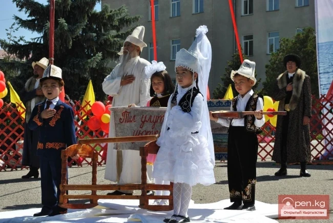
History of the founding of the city of Karakol (Przhevalsk).
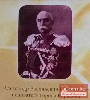
The founding of the city is associated with the name of the well-known baron A.V. Kaulbars in Semirechye. In 1869, he was assigned to reconnoiter the Zaisyk-Kul Tien Shan. Upon arriving in the Issyk-Kul valley, he was tasked with:
a) After thorough reconnaissance and gathering all necessary information, to choose a suitable place for relocating the existing city and fortification on the Ak-Suu River, the location of which was deemed inconvenient both for trade and purely military purposes.
b) to carry out detailed surveying of the chosen site for the new city.
From the memoirs of Captain of the General Staff A.V. Kaulbars, in the spring of 1869, he was sent at the head of a military-scientific expedition to the Tien Shan, one of the tasks of which was to explore the pre-Issyk-Kul area (to compile a map, conduct topographic surveys, determine altitudes, etc.) and to choose a site for the county city-center in place of the Ak-Suu fortification (now from Teploklyuchenko), which stood aside from trade and caravan routes.
"Resolving the issue of choosing a site for the new city was an extremely difficult and responsible task," wrote A.V. Kaulbars. After consulting with local experts - Kyrgyz aksakals and county chief A.P. Chaikovsky, it was decided to found the city at the mouth of the Karakol River, 12 km from Lake Issyk-Kul, where several families of Tatar and Uzbek traders from the Ak-Suu fortification had already moved. With the assistance of the surrounding Kyrgyz, A.V. Kaulbars and his companions, soldiers and Cossacks managed to successfully complete the difficult task of laying out the city by July 1, 1869: "the streets, squares, and trading house of the city of Karakol were laid out... the new city was intended by its location to bring the light of Russian culture into the depths of the Tien Shan" (A.V. Kaulbars). (Kaulbars thus practically fulfilled his mission. The continuation of the construction was handed over to the Issyk-Kul county chief A.N. Chaikovsky.)
In 1870, during a new visit to the city, A.V. Kaulbars noted that the garrison occupied the already built barracks, and there was brisk trade in the trading house.
A little later, in February 1870, a government decree was adopted to transfer the Issyk-Kul administration from Ak-Suu to the fortification of Karakol. Here is the full text of this document.
Emperor Alexander II February 1870 48005 - February. The named decree, announced in the order of the military department, is about the transfer of the administration of the military commander of the Ak-Suu management, Semirechye region, and its garrison to the newly erected fortification on the Karakol River. His Imperial Majesty, having approved the order of the chief commander of the Turkestan military district regarding the transfer of the administration of the military commander of the Ak-Suu fortification, Semipalatinsk region, and its garrison to the newly erected fortification on the Karakol River, which flows into the southeast corner of Lake Issyk-Kul, has graciously commanded to name the latter fortification Karakol; the Ak-Suu fortification is to be considered abolished."
At the end of the 19th - beginning of the 20th century, the city served as a base and starting point for domestic and foreign expeditions into the inner Tien Shan and Central Asia.
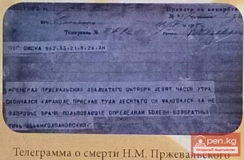
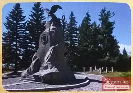
Karakol (Przhevalsk) served as a usual starting point for mountain journeys; here the renowned Russian traveler, researcher of Central Tien Shan and Central Asia and adjacent territories, N.M. Przhevalsky spent his last days. He arrived in Karakol not in good health, having caught a cold while hunting. The illness progressed, and on October 20, 1888, the irreparable happened; the world-renowned traveler-scientist, N.M. Przhevalsky passed away.
Soon after this sad event, a petition was raised by the Steppe Governor-General and the commander of the troops of the Omsk military district to rename the city of Karakol to Przhevalsk, to immortalize the name of N.M. Przhevalsky in Central Asia, "to assign his name to the hospital barrack, and at the place where he breathed his last, to nail a board with the inscription: 'Here died Major General Przhevalsky on October 20, 1888, at 9 o'clock in the morning'." The petition was granted, and in the spring of 1889, a government decree was issued to rename the city of Karakol to Przhevalsk - here is the full text of the decree: "5829 - March 7. The highest order, announced by the military minister (Collection of decrees 1889, May 16, article 371). On the renaming of the city of Karakol, Semirechye region, to Przhevalsk. His Imperial Majesty, upon the most humble report of the military minister, on March 7, 1889, graciously commanded to consent: 1) to rename the city of Karakol, Semirechye region, to Przhevalsk, to immortalize the memory of Major General Przhevalsky in Central Asia and 2) to assign the name of General Przhevalsky to the hospital barrack in which he died." In 1923, the city was returned to its original name - Karakol, and on May 31, 1939, in connection with the centenary of the birth of N.M. Przhevalsky, at the request of the city's population, a decree of the Presidium of the Supreme Soviet of the Kyrgyz SSR renamed the city back to Przhevalsk.
Bibliography
1. Central State Historical Archive of the USSR, Library of the p.s.3 collection, vol. IX. 1889. p. 87.
2. Branch of the Central State Archive of the Republic of Kazakhstan, city of Przhevalsk. Special folder, memoirs of General of Cavalry Baron A.V. Kaulbars. L.
3. Central State Historical Archive. Library p, s, vol. XU; 1870, p. 149. 3 Turkestan Gazette 524 June 13, 1889. p. 93
4. Branch of the Central State Archive of the Republic of Kazakhstan, city of Przhevalsk. The city of Przhevalsk is 100 years old. Statistical report, p. 3.
5. Kaulbars A.V. On the history of the founding of the city of Przhevalsk (Copy), materials of the state archive of the Issyk-Kul region in the city of Przhevalsk.
Read also:
Karacol - The Last Harbor of N. M. Przhevalsky
Nikolai Mikhailovich Przhevalsky. The first explorer of the nature of Central Asia. The residents...
Peak Karakol
Peak Karakol (5281 m) Located in the Oguz Bashi massif on the southern shore of Lake Issyk-Kul;...
City of Karakol
...
The History of the Development of Przhevalsk - Karakol. A Look at the Past and Present
Dear residents and guests of the city of Karakol, the "VisitKarakol" project, in...
National Nature Park "Karakol"
Karakol National Nature Park The park was established in accordance with the Resolution of the...
The Karakol Residents Celebrated a Triple Holiday
Today, the city of Karakol is celebrating the Independence Day of the Kyrgyz Republic, the 145th...
Zone "Talas"
The "Talas" zone is located in the central part of the Talas River valley and includes...
City of Balykchy
On the western shore of Lake Issyk-Kul, at the junction of the roads Bishkek — Naryn and Bishkek —...
Karakol Historical and Local Lore Museum
Traveling along the eastern part of the Issyk-Kul Lake coast, you will definitely find yourself in...
Kara-Tor Waterfall
Kara-Tor Lower Waterfall In the Naryn region of the Kochkor district, in the upper reaches of the...
Ski Resort "Karacol"
The ski resort "Karakol" is located in a gorge, at an altitude of 2300 meters above sea...
An Ancient Scythian City Found at the Bottom of Issyk-Kul
Divers managed to retrieve many finds from the bottom, including a whole ceramic vessel, a large...
A Bicycle Ring Route Around Issyk-Kul is Planned
Bicycle paths are planned to be built along the Issyk-Kul coast Ring road around Issyk-Kul. What...
The Birth of the City of Karakol
Birthday of Karakol (Przhevalsk) - July 1, 1869 History has preserved for us the exact date,...
Peak Djigit
Peak Djigit - height 5170 meters. It is located in the main watershed ridge of the Terskey Alatau...
Guest House "Boomerang"
Guest House "Boomerang" on Issyk-Kul The resort town of Cholpon-Ata is located on the...
Waterfall "Maiden's Tears"
Waterfall "Maiden's Tears" for Family Happiness Located in the Jeti-Oguz gorge,...
Ski Resort "Karokol"
Over 20 km of trails can satisfy both experienced skiers and those conquering mountain slopes for...
Guest Houses. Karakol
Guest Houses of Karakol In recent years, the hotel service sector in the city of Karakol has been...
Western Karakol or Suusamyr
The length of the Suusamyr River is about 80 km. It begins at the watershed of the Ala-Bel Pass...
Photo - A City with an Interesting "Highlight" in the Mountains of Kyrgyzstan
This year, Naryn is celebrating its 156th birthday. The correspondent of Turmush discovered...
Renaming Karakol to Przhevalsk
City in Honor of N.M. Przhevalsky Starting from 1875, the growth rate of the city significantly...
Chon Ak-Suu Gorge or Grigorievskoe
Grigorievskoe Gorge is one of the wonderful and picturesque natural attractions Chon Ak-Suu Gorge,...
Sharsheev Kanibek
Sharsheev Kanibek (1950), Doctor of Physical and Mathematical Sciences (1999), Professor (2002)...
Karakol Celebrates the 20th Anniversary of the State Emblem of Kyrgyzstan
On July 23, 2014, under the chairmanship of Deputy Prime Minister Elvira Sarieva, a plan of events...
Issyk-Kul - the Mountain Pearl.
Issyk-Kul - the Mountain Pearl. The most beautiful and largest lake in Central Asia is Lake...
"Suusamyr Zone"
The Suusamyr Zone includes the eponymous high-altitude valley stretching 155 km. To the north, it...
Issyk-Kul Region
The Issyk-Kul Region is located in the eastern part of Kyrgyzstan. It was established on November...
Karakol. Terskey Ala-Too. Backcountry and Freeride in Kyrgyzstan.
Russian fans of extreme freeride and backcountry made an introductory video about Karakol and...
The title translates to "The Village of Kara-Kuldja."
Kara-Kulja Village is the center of the eponymous district Karakulja (archaic: Kara-Kulja; at the...
The ski resort "Karokol" has once again become the first in the CIS.
The ski resort Karacol is in first place. The ranking of ski resorts in the former USSR countries...
The title translates to "The Village of Ak-Terek."
Ak-Terek — a village in the Jeti-Oguz District of the Issyk-Kul Region of Kyrgyzstan. It is the...
Attractions of the City of Osh
Osh - one of the oldest cities in Central Asia, located on the southeastern edge of the Fergana...
City of Aydarken
Aydarken – a small town and industrial center in the central part of the Batken region. The...
China (Xinjiang Uygur Autonomous Region of the People's Republic of China)
China is a vast country rich in tourist resources. The country is abundant in attractions and...
Zheti-Oguz (Video)
] The Jeti-Oguz Gorge is located 30 km west of the city of Karakol on the northern slopes of...
Osh - "Southern Capital" of Kyrgyzstan
Osh - "The Southern Capital" of Kyrgyzstan. The city of Osh is the administrative center...
Attractions of the Southern Shore of Issyk-Kul and the Terskey Alatau
Tamga-Tash. At an altitude of 1684 m, in a beautiful old park on a steep cliff by Lake Issyk-Kul,...
Dobaev Kyrgyzbay Dushenbekovich
Dobaev Kyrgyzbay Dushenbekovich (1954), Doctor of Pedagogical Sciences (2000) Kyrgyz. Born in the...
Karakol Ski Resort in First Place
Rating of ski resorts in the former USSR countries based on vacation costs....
City of Cholpon-Ata
If you drive eighty kilometers along the northern shore of the lake from the city of Balakchy, you...
Zone "Osh"
The "Osh" zone introduces tourists to the attractions of the ancient city of Osh. The...
Kant
The city of Kant is a city of district subordination. In Kyrgyz, "kant" means sugar; the...
The Village of Tyup
Tyup – a village and the center of the eponymous district in the Issyk-Kul region. It is located...
Issyk-Kul - the most beautiful lake in Central Asia
The most beautiful and largest lake in Central Asia is Lake Issyk-Kul. For this reason, it is...
Karakoil sixth in the top 10 ski resorts of the CIS
Karakol makes it to the top 10 ski resorts of the CIS for winter recreation The analytical agency...
Arguments in Favor of Identifying the Settlement of Sarybulun with Chigu
“The City of the Red Valley” In connection with the discovery of a large settlement from the 1st...
City of Shopokov
The city of Shopokov is located at the northern slope of the Kyrgyz Range at an altitude of 740...