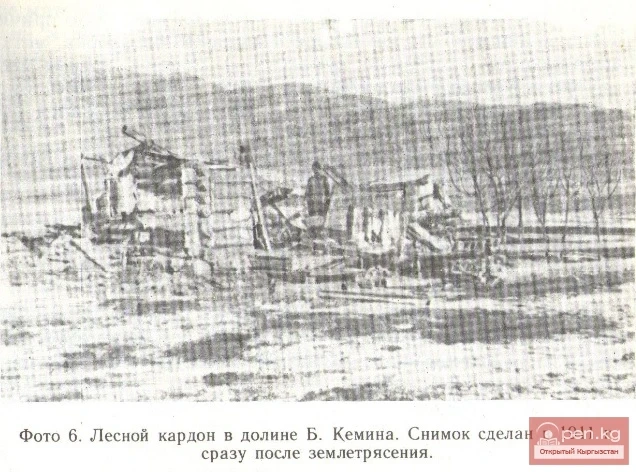
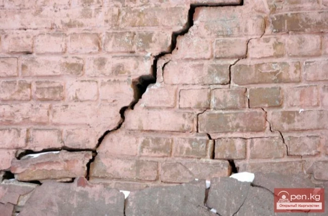
The territory of Kyrgyzstan is one of the most seismically active regions on the planet, where earthquakes of varying strength (from weak to catastrophic) have occurred, are occurring (up to 1500 tremors per year), and will continue to occur. The high seismicity is due to the activity of tectonic processes and a complex geological-tectonic situation. Information about ancient strong earthquakes that occurred in the Tienir-Tuu area is presented in the form of seismogravitational paleomorphs (landslides, collapses, mudslides, debris, etc.). They can be found throughout Kyrgyzstan. In the historical memory of people, the first information about catastrophic natural disasters dates back to the time when an ancient city (the name of which is unknown) was completely destroyed in the valley of the Chon-Kemin River. More specific data refers to the end of the 18th century (in 1770, near the village of Belovodskoye, "a lake was buried") and to the beginning of the next century (in 1807, in the area of Almaty, a "terrible disaster occurred, the echoes of which reached Kyrgyzstan"). Detailed systematic information about earthquakes begins with the description of the Belovodskaya catastrophe of 1885 (9-10 points). As a result of this earthquake, the villages of Belovodskoye and Kara-Balta were completely destroyed, landslides, mudslides, and rockfalls occurred on the slopes of the Kyrgyz ridge, and a crack up to 20 km long and 2 m wide formed in the foothills. In Bishkek, Sokuluk, and Chaldybar, where the earthquake was felt with a force of 7-8 points, dilapidated houses were destroyed, and many buildings were damaged. In 1911, a grand seismic catastrophe occurred in Northern Tienir-Tuu (the Kemin earthquake with a force of 10-11 points), resulting in the death of more than 1500 people and the destruction of villages in the valley of the Chon-Kemin River and on the northern shore of Lake Issyk-Kul. The length of the zone of major surface disruptions (cracks, landslides, etc.) reached 250 km. In June 1938, an earthquake with tremors of up to 8 points occurred with the epicenter near the Zhel-Aryk station (eastern end of the Chui depression). The 9-10 point Chatkal earthquake of 1946 covered a vast territory. Many structures and buildings were severely damaged in the cities of southern Kyrgyzstan and neighboring states (Osh, Jalal-Abad, Andijan, Tashkent). Villages located in the epicentral zone (with a length of up to 100 km and a width of 15-20 km) were turned into heaps of rubble, and significant landslides and rockfalls occurred in the valleys and foothills. Large cracks opened, and part of Lake Sary-Chelek was blocked by debris. The Chatkal earthquake triggered numerous aftershocks (more than 230 were recorded in the month following the main shock). In 1970, an 8-9 point Sarikamysh earthquake occurred in the eastern part of the Issyk-Kul depression. In terms of the size of the epicenter and the energy released, it is the largest on the northern slopes of the Teskey Ala-Tuu. The zone of maximum tremors (20x10 km²) covered several villages, where many residential buildings were damaged or partially destroyed. Mass landslides, mudslides, and rockfalls were noted in the mountains. In 1978, the Tyup earthquake occurred, with an intensity of 8-9 points at the epicenter. More than 50 settlements in the Tyup region were damaged and destroyed. In the watershed areas of the Kungey Ala-Tuu ridge, widespread small-volume landslides, rockfalls, and the formation of cracks in rocky soils were recorded. In 1977, an 8-9 point earthquake occurred in the Batken region of the Osh region (southeastern part of the Fergana Valley), which was felt over a large part of Kyrgyzstan, Uzbekistan, Tajikistan, and also in the southwestern regions of Kazakhstan. The maximum tremor was felt between the Sokh and Isfara rivers, where settlements (more than 8 villages) were destroyed. An earthquake of the same strength (8-9 points) occurred in the southwestern part of the Alai depression, designated as the Daroot-Korgon earthquake. Major settlements did not fall within the epicentral zone, but shepherd's houses and adobe pens for livestock were completely destroyed, and there were human casualties. In May 1992, the Kochkoratin earthquake (7-8 points) occurred in southern Kyrgyzstan. The epicentral area extended 40 km in length and 5-7 km in width. Kochkor-Ata and nearby villages were destroyed, and landslides occurred.
One of the strongest earthquakes in recent years was the Suusamyr earthquake (August 1992), which covered the territory from the Kazakh steppes to the Northern Pamir in the south. The zone of maximum tremors covered the southern and northern slopes of the Suusamyr ridge, the Suusamyr, Aramzin, Ketmen-Tyobon, and Talas depressions. Within its limits, all settlements were affected, with 60-80% destruction. Landslides and mudslides in the mountains led to human casualties and significant livestock losses. The natural disaster caused significant damage to the Bishkek-Osh highway. In January 1997, a 7-7.5 point earthquake was recorded in the Jaman-Davan mountains of the Naryn region, which was felt throughout the territory of Northern Tienir-Tuu.
Over the past 100 years, numerous catastrophic earthquakes have occurred in Kyrgyzstan, destroying villages and cities and claiming thousands of human lives. No one has yet succeeded in preventing an earthquake, but there is a possibility to significantly reduce the inevitable losses. The decisive role in this is played by measures that ensure the seismic resistance of residential and industrial construction objects. They are based on seismic zoning maps, which serve as regulatory documents during construction.

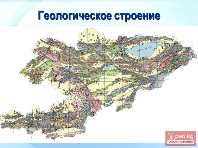
The first such map for Kyrgyzstan was compiled in 1964. However, it was based on relatively limited material, which reduced the reliability of the map regarding seismic hazard data. In 1979, the Institute of Seismology of the National Academy of Sciences of Kyrgyzstan published a seismic zoning map of the republic, compiled at a scale of 1:250,000. This map indicated not only the effects caused by past earthquakes but also identified the locations and strength of future earthquakes and their probable recurrence. A cycle of work reflecting the results of research on the development of scientific and methodological foundations for assessing the degree of seismic hazard over the past 15 years, as well as the need of construction organizations for a larger-scale seismic zoning map, led to the necessity of creating a new map at a scale of 1:1,000,000, which was compiled in 1995 (published in 1996). This map highlighted three types of initial intensity zones: 1) zones with a strength of 9 points and a magnitude of 7.5, where residual deformations of both seismogravitational and seismic rupture nature are most likely to occur; 2) zones with a strength of 8 points and a magnitude of 6.5-7.0, which are widespread almost throughout Kyrgyzstan; 3) zones with a strength of less than 8 points and a magnitude of less than 7, which include only the northwestern corner of Kyrgyzstan, located in the lower reaches of the Ak-Suu, Kara-Balta, and Aspara rivers. The first type includes the sublatitudinally elongated North Tienir-Tuu and the southern Suusamyr and Jumgalo-Teskey zones. The North Tienir-Tuu zone includes the northern slopes of the Kyrgyz ridge, Kungey Ala-Tuu, their junction — the Boom gorge, part of the Chui and Issyk-Kul depressions. The Suusamyr zone is stretched almost latitudinally along the eponymous ridge and depression. Within the Southwestern Tienir-Tuu, these zones include: the Talas-Fergana fault zone (with its split from the northwestern part into several subparallel branches), the Tarsk-South Fergana, and the Issykkul-Kakshaal zones. The Talas-Fergana zone is elongated along the eponymous fault and Fergana ridge. To the northwest of the Naryn River valley, from the Talas-Fergana zone to the southwest, the North Fergana, At-Oynok, and Chandalash branches extend. The Tarsk-South Fergana zone, extending to the southeastern closure of the Fergana depression, is formed by two intersecting zones: the sublatitudinal South Fergana and the northwestern Tarsk extension. The Issykkul-Kakshaal zone runs in the extreme south of the republic through the Alai and Zaalai ridges and the Alai depression.
Using their theoretical and methodological developments, scientists from the Institute of Seismology of the National Academy of Sciences of the Kyrgyz Republic have constructed detailed seismic zoning maps for several important economically significant territories of the republic (Chui, Issyk-Kul depressions, and the north of the Osh region), as well as microzoning maps for cities, towns, and construction areas.
The creation of all the aforementioned maps will allow builders to properly plan, locate, and construct buildings and structures, thereby minimizing the destruction of buildings and human losses.