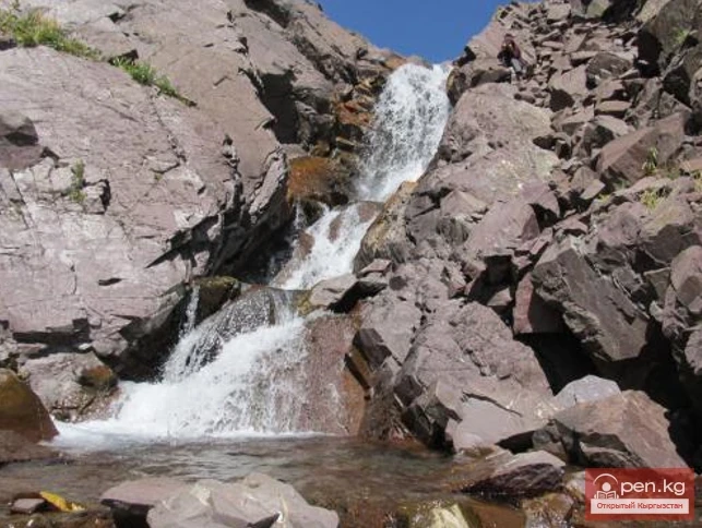
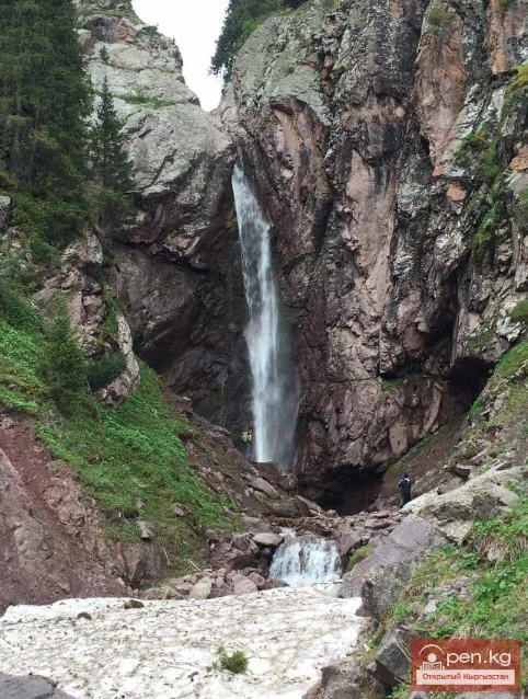
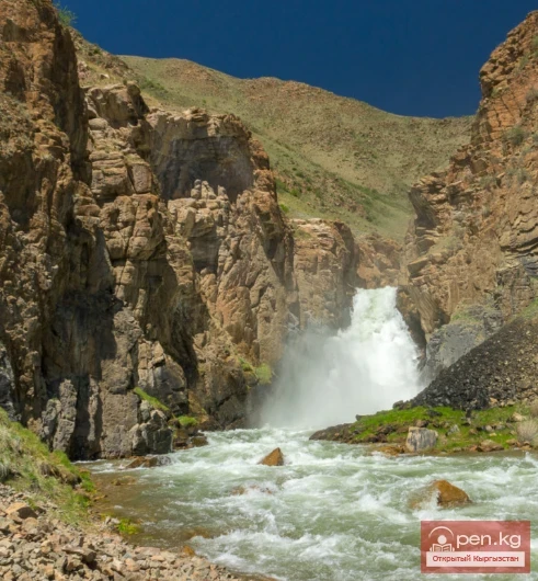
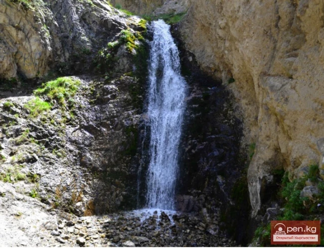
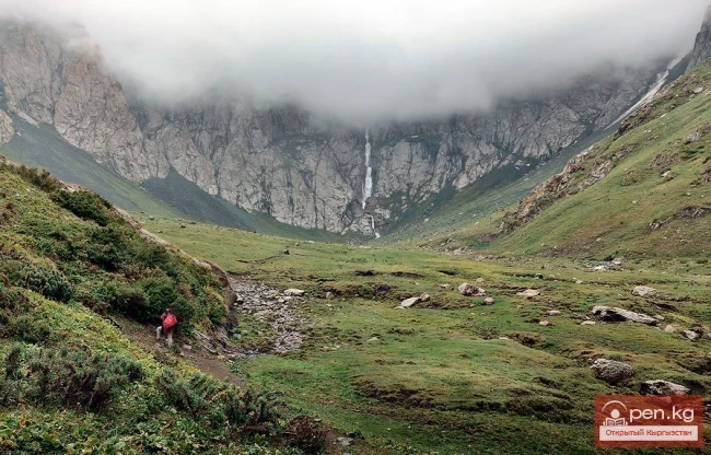
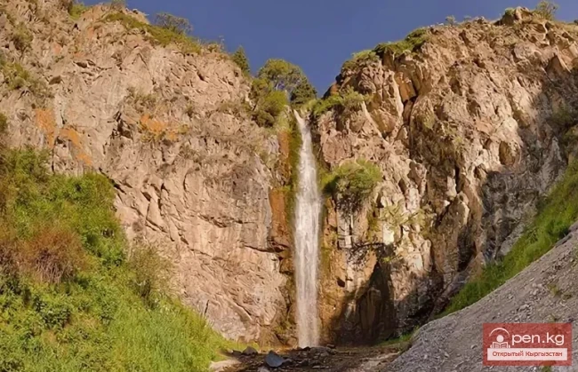
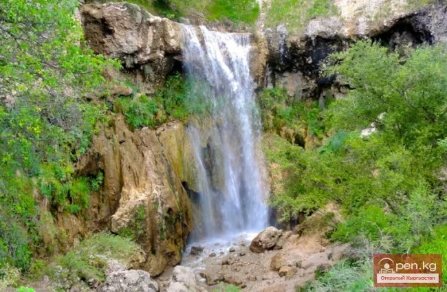
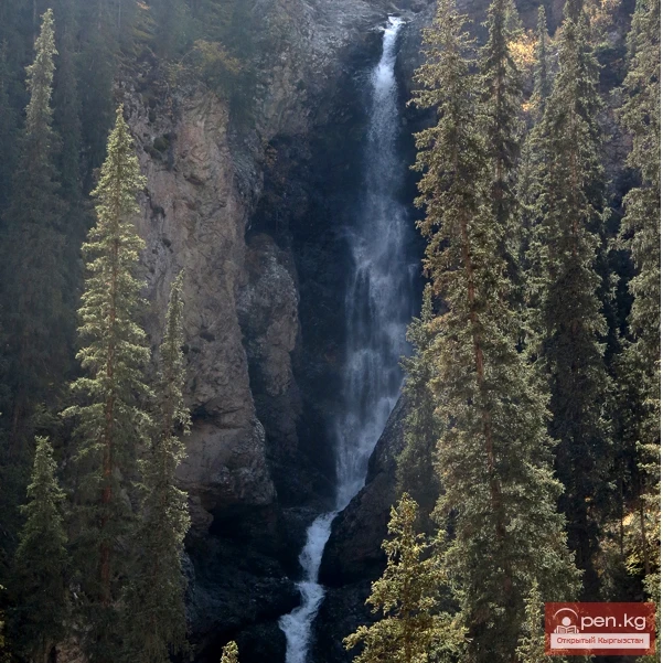
Waterfall - Birbulak (Raspberry). It is located in the Chui region, 20 km from Bishkek, behind the village of Tash-Dobo (formerly Vorontsovka), about 30 minutes by car from the city. You can climb the rocks and visit the waterfall. The height of the waterfall is 10-12 m. The elevation above sea level is 2030 m. From the "Kyrgyzstan" sanatorium to the waterfall is 7-8 km.
River Tributaries The existence of powerful glacial nodes, large areas occupied by snowfields, and groundwater outflows in the Tien Shan and Alai mountains leads to the formation of a dense and branched hydrographic network. All major rivers of Kyrgyzstan originate high in the mountains near glaciers and snowfields. The water flow of the rivers is related to the absolute basins, their degree of glaciation, and the area of snowfields that feed the rivers. In the lower reaches, due to intense
Waterfall in the Grigorievsky Gorge Kara-Chyn Waterfall (at least, that's how local kumys healers refer to it). It is located on the right side of the Grigorievsky Gorge, directly behind the second lake. There is no information about this natural beauty anywhere. It has 3 cascades, with a total height of approximately 60 m, and the height of the lower cascade is 15 m.
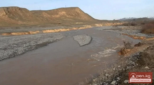
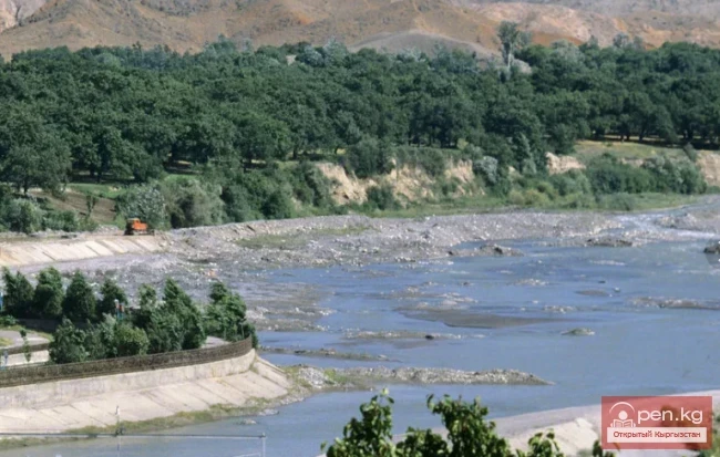
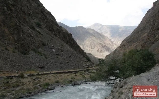
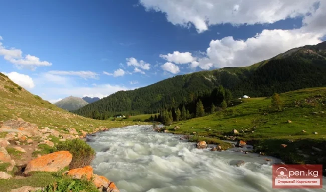
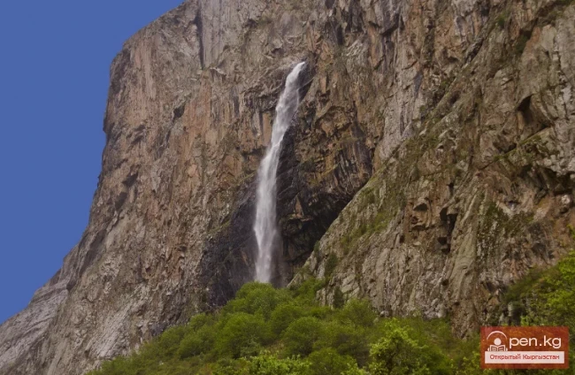
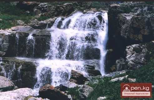
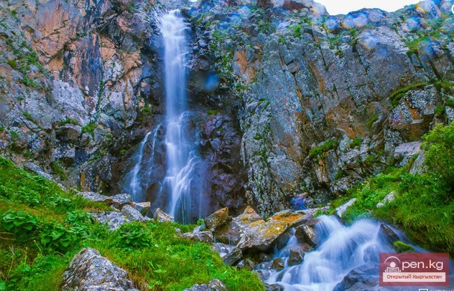
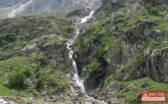
Sokuluk Ashutor Waterfall Before the Sokuluk waterfall, there is the Ashutor gorge with a cascading waterfall. The waterfall consists of numerous cascades with a height of about 80 meters. It is located 7.5 km away. Ashutor, the gorge (leads to the Suusamyr pass). The left tributary of the Sokuluk gorge. The height above sea level is 2600 m. There is a route between the Sokuluk and Ala-Archa gorges through the Ozyorny pass (3900 m). During the Soviet era, numerous flocks of sheep were driven
Kara-Tor Lower Waterfall In the Naryn region of the Kochkor district, in the upper reaches of the eastern Karakol River on the southern slope of the Kyrgyz Ridge, there is the Kara-Tor gorge. Here, at an altitude of 3200 meters, is a multi-tiered waterfall of the same name. It is modestly visible from the dirt road leading to the Karakol Pass. From the road to the waterfall, it is 1.5 km along a little-used trail along the riverbed. The total length of the waterfall is about 300 meters.
Kok-Bel Waterfall. On the way to the waterfall, there is a breathtaking view of the Jyrgalan valley and the village as a whole. There are geological trails leading all the way to the waterfall. These earthen geological cuts were made back in Soviet times and were used by geological exploration teams. Now, they are used by tourists.
Son-Kul. Naryn Region. Before ascending to Lake Son-Kul, just before the 38 Parrots Pass, you can admire a rather powerful waterfall. It is located approximately 10 km from the outlet of the lake on the Son-Köl River. The shady path to the waterfall lies between Lake Son-Kul and the road coming from Naryn through the Dolon Pass. It is located on the right side after descending from Lake Son-Kul via the Terskey-Torpok Pass. The height of the waterfall is about 25-30 meters. The elevation above
Sharkyratma Waterfall It is located about a 40-minute walk from the alpine camp on the way to the Ratsek stops. The cascade of rapids and small waterfalls begins about 80-100 meters above the crossing of the river with the trail. The first icy wall is about 2 meters high and can be passed or bypassed right there along a rocky ledge. It gets more and more interesting from there. The cascade ends with a three-tiered waterfall: the lower ledge is approximately 70 degrees and 8-9 meters high,
Kasansay (Kyrgyz: Kasan-say, Uzbek: Kosonsoy) A river in Kyrgyzstan and Uzbekistan, a right tributary of the Syr Darya. In its upper reaches, it is called Chalkydysay. Length — 127 km, basin area 1780 km². It originates on the southern slope of the Chatkal Range in the Western Tian Shan.
Issyk-Ata — a gorge located 77 km from Bishkek. It is here that the famous Issyk-Ata hot hydrogen sulfide springs, an ancient depiction of Buddha, and a multitude of other attractions can be found. In the 12th-14th centuries, the gorge was the cradle of Buddhism in the region, which is why Issyk-Ata is not just a unique natural monument, but also a place with its own amazing history. The mountain river Issyk-Ata also attracts fishermen from all over Kyrgyzstan, primarily because there is
Tauskandarya - "Raging River" A river in Kyrgyzstan and the Xinjiang Uygur Autonomous Region of China, in its upper reaches known as Kokshaal. It originates in the mountains south of the Kyrgyz city of Naryn. It flows eastward and merges with the Aksu River, which in turn is a tributary of the Tarim River. It is formed by the confluence of the Aksay and Myuduryum rivers. The name "Tauskandarya" likely comes from the combination of the words dar'ya ("river")
Baš-Kaindy or Shaar Naryn Region, Baš-Kaindy Gorge. The height of the waterfall is 220 m, considering the cascades – 400 m. Height above sea level: 3200 m. It is also called Shaar. In Kyrgyz, waterfall is "sharkyratma." Possibly derived from the shortened word "shar."
Kyzyl-Suu (Kyzyl-Suu River, Красная река) - a river in Kyrgyzstan and Tajikistan, the right source of Surkhob. It flows from east to west through the Alai Valley. At an altitude of 1834 m, merging with Muksu near the village of Dombrach, it forms the Surkhob River. The length is 242 km (from the source of Aylama to Muksu). Of these, 193 km flows through the territory of Kyrgyzstan and 49 km - through Tajikistan. The basin area is 8380 sq. km.
Kashgar Kashgar (Kyzyl-Suu, Uluu-Chat (Ulugchat), Kabaatsu, Kyzylsu, Aavatusten Canal, Kashgar, Faizabad Darya, Chon-Kashgar Darya) is a river in the west of China, with its upper reaches in Kyrgyzstan and Tajikistan. Previously, Kashgar flowed into the Yarkand River, but now it is lost in the sands. Length — 765 km, including 685 km on the territory of China, with a catchment area of 90.8 thousand km². The average water flow near the village of Kafka is 80 m³/s.
The main channel of the Ak-Suu River is at least 20-22 kilometers long. The lower part of the valley, crossing the first terrace of the Chatkal Valley, has a wall-like character. Passing through the second terrace of the main valley of the Chatkal River, the Ak-Suu has carved a deep canyon that is completely impassable for 1-1½ km. Then the valley widens somewhat, with mixed forests growing near the water, and many junipers and shrubs on the slopes. As it approaches the Main Ridge, the valley
Aflatun River – the largest right tributary of the Kara-Suu River in the Jalal-Abad region. The valley of the Aflatun River leads to the most accessible pass connecting the Chatkal Valley with Fergana. The lower steppe part of the valley stretches for about 6-7 kilometers. Two river terraces are covered with dry grass, and only at the very bottom, by the riverbed, there is a narrow strip of green trees. Further, the river deepens into a rocky canyon, the walls of which rise as they approach
Karakulja The Chatkal River in its upper reaches is called Karakulja (translated - Black Ram), which is formed by the confluence of Kara-su and Ak-su. It flows through the territory of the Osh region of Kyrgyzstan. The two main sources of Kara-su originate from small glacial lakes at the foot of the ridge connecting the Chatkal Range with the Uzun-Akhmat and Talas ranges. The more water-rich Ak-su River originates from a valley-type glacier flowing down from the Chatkal Range. This glacier,
Kursheb, Kursheb River, in the upper reaches — Gulcha, A river in Kyrgyzstan, flowing through the Osh region, a left tributary of the Karadarja River (Syr Darya basin), it flows into the Andijan Reservoir. The river originates from the northern slope of the Alai Range and is classified as a snow and glacier-fed river. After receiving the Jusal River from the right, the river Gulcha is named Kursheb. Kursheb flows through a deep valley and has about 40 tributaries along its entire length. It is
Kugart The Kugart River (Kek-Art), in the valley of the same name in southern Kyrgyzstan, is a right tributary of the Karadarja River, originating on the southwestern slopes of the Fergana Range. It flows through the city of Jalal-Abad. The river is fed by snow, has a wide gravel floodplain, and steep banks, and is characterized by significant variability in flow, increased sediment transport, and a debris flow nature. A feature of the Kugart River is that it practically does not carry its
Isfará — a river of the Syr Darya basin The river basin encompasses the Isfara and Kanibadam districts of the Sughd region of Tajikistan, the Batken district of the Batken region of Kyrgyzstan, and the Besharik district of the Fergana region of Uzbekistan. It originates from the glaciers of the Turkestan Range at an altitude of over 5000 m and flows north through the Fergana Valley to the Syr Darya River. From the Isfara district to the northern foothills of the Turkestan Range, where the
Chatkal - a mountain river in Kyrgyzstan and Uzbekistan, Before the formation of the Charvak Reservoir, it was the left tributary of the Chirchik River (Syr Darya basin). It originates on the southwestern slopes of the Talas Alatau. In its upper reaches, it flows through a wide ancient glacial valley. Below the confluence with the Ters River, the valley narrows, transitioning into a deep gorge. The banks of the Chatkal River form terraces 7-10 m high. The river often splits into channels. After
Isfayramsay A river in Kyrgyzstan and Uzbekistan, a left tributary of the Syr Darya. Its total length is one hundred and twenty-two kilometers with a catchment area of two thousand two hundred twenty square kilometers. The river originates from the spurs of the Alay Range. In its upper reaches, Isfayramsay is known as Tengizbay. It flows in a northern direction. The river is part of the Great Fergana Canal system. From the city of Kuvasay, the canal named after the XVII Party Congress branches
Aspara A river in the Panfilov District of Chuy Region, Kyrgyzstan, and the Merken District of Zhambyl Region, Kazakhstan. It is part of the Chu River basin (Shu). The Aspara River is a tributary of the Chu River and belongs to the group of rivers on the northern slope of the Kyrgyz Range. The river originates in the Western Tian Shan in the northwest of Kyrgyzstan and flows north, crossing into southern Kazakhstan to the Kuragaty River. On the left bank of the Aspara River is the Merke River
Sokuluk (Belogorka). Chuy Region, Sokuluk Gorge. The waterfall is located 80 km southwest of Bishkek. The hike from the parking area takes 1-1.5 hours. The height of the waterfall is about 60 m. The height above sea level is 2200 m. The water, when falling, hardly reaches the ground, dispersing and turning into a cloud of mist. The spray from the waterfall can be felt from about 200 meters away, and it is cold to stand near the waterfall even on the hottest day. The giant column of water
Burgan-Suu Gorge Waterfall A hike to the waterfall will take about two days, as the gorge leading to the waterfall is long. The starting point for the hike is the village of Zharkonbaev (a little east of the village of Ananyev). If there is transport available, you can reach the village of Karoool-Debe (at the beginning of the gorge). From there, you can either walk or ride a horse. Along the way, you will need to cross the main river several times (on the General Staff map, it is called, like
Bright and Colorful Ak-Sai. The height of the waterfall is 25-30 m (2700 m above sea level). Chui region, Ak-Sai gorge. Right tributary of Ala-Archa (2100 m above sea level). Translation from Kyrgyz: ak – white, sai - river. The Ak-Sai waterfall is the most visited attraction of the Ala-Archa National Park. The waterfall is located just 42 km from Bishkek in the extraordinarily beautiful Ala-Archa gorge within the namesake park. From here, a beautiful panorama opens up to the snowy peaks and
Big Kegety Waterfall The waterfall is located in the Kegety Gorge, which is in the Chuy region, 18 km south of the city of Tokmak and 50 km east of the capital of the Republic, Bishkek. The gorge is part of the Kyrgyz Ridge, situated on both the southern and northern sides of the mountain system. The maximum height of the gorge at the source of the river of the same name is 3150 meters above sea level, while at the entrance to the gorge it is 1250 meters, thus the total elevation drop is
Dove Watering In the Chon-Kurchak gorge, there is the most unusual and beautiful waterfall, located just 30 km south of Bishkek. This waterfall is one of the most famous and beautiful waterfalls in Kyrgyzstan, where the water cascade plunges from a sheer cliff at a height of 26 meters. Locals call it "Dove Watering," and flocks of wild doves can mainly be seen here in the summer. The water falls from a great height from a narrow cliff. If you walk around, you can enjoy the view from
The Alamedin Waterfall is located in the gorge of the same name, 40 kilometers from the city of Bishkek. The waterfall is slightly off the main road, and to reach it, one must walk for an hour and a half through the gorge. The nature of the Alamedin gorge is very diverse, characterized by picturesque views and unprecedented beauty, a riot of colors. The waterfalls in this gorge are a true wonder of nature. They cascade down rocky cliffs. Nearby, there is a forest with a beautiful birch grove,
Waterfall "Maiden's Tears" for Family Happiness Located in the Jeti-Oguz gorge, about thirty kilometers east of Lake Issyk-Kul in Kyrgyzstan, it attracts the attention of mountain tourism enthusiasts with its clear waters and beautiful views that open up from the trails leading to it. The waterfall can be reached from the city of Karakol, the administrative center of the Issyk-Kul region. The Maiden's Tears waterfall (the variant "Maiden's Braids" is rarely
Arslanbob Waterfalls One of the most beautiful resorts in southern Kyrgyzstan is the Arslanbob region, known not only for its unique relict walnut forests, which are the only ones in the world, but also for its fairy-tale waterfalls created by mountain rivers rushing through rocky gorges. One of the most famous of these is the Arslanbob waterfall. It consists of two waterfalls: the Small and the Big, so the name "Arslanbob Waterfalls" is more accurate.
Uch-Kurgan Hydroelectric Power Station — a hydraulic engineering structure, a run-of-river hydroelectric power station (HPP), built on the Naryn River, 12 kilometers from the city of Uch-Kurgan (Namangan region of Uzbekistan) and two kilometers from the Uch-Kurgan — Tash-Kumyr railway line. This convenient location for constructing the HPP was first selected by engineer Kuznetsov in 1913. On November 30, 1958, the concrete was laid in the building of the Uch-Kurgan HPP. On January 27, 1959,
Tortkul Reservoir is a unique structure. It is located in the Batken region on the Isfara River. The area of the reservoir is 6.6 square kilometers, and its volume is 90 million cubic meters of water. Since the river is fed by glacial and snow melt, the reservoir is primarily filled due to melting snow and other sources. Approximately 60 million cubic meters are used annually during the irrigation season, leaving about 30 million in reserve. The critical volume is 15 million cubic meters of
Reservoir in the Valley of the Ak-Bura River The location of the Papan irrigation reservoir basin is in the valley of the Ak-Bura River near the Kaptarsky massif, after the dam was built at the point of greatest narrowing of the Papan Gorge, in the Osh region of southern Kyrgyzstan. It is located 20 km south of the city of Osh. The structure can withstand an earthquake of up to 9 points. The dam of the reservoir has a length of 90 meters and a height of 70 meters. Until 2003, the reservoir was
Tears of the Leopard Waterfall – the most famous waterfall of the Barskoon Gorge. One of the most beautiful gorges in Kyrgyzstan, the Barskoon Gorge (in Kyrgyz, Barskoon) is located on the southern shore of Lake Issyk-Kul, 90 km from the capital of the Issyk-Kul region, the city of Karakol. In the Barskoon Gorge, among relict firs and pines, three waterfalls originate from the glaciers of the high mountains. The lowest of them is the Manas Bowl, slightly higher is the Old Man's Beard, and
Kurpsayskoye Reservoir — a canyon-type reservoir Kurpsayskaya Hydroelectric Power Station — HPP on the Naryn River in Kyrgyzstan. It is the second most powerful hydroelectric station in the country, after the Toktogul HPP. It is part of the Naryn-Syrdarya cascade of hydroelectric power stations. The dam of the HPP forms the Kurpsayskoye Reservoir with weekly regulation. It is located in a narrow mountain gorge. In the area of the dam, the gorge with slopes of 35-40 degrees rises above the bed
Orto-Tokoy Reservoir — a reservoir on the Chu River. It is located 2 km west of the village of Orto-Tokoy, on the border of Naryn and Issyk-Kul regions, at an altitude of 1700 meters. The construction plan for the reservoir was approved by the decree of the Central Committee of the All-Union Communist Party (Bolsheviks) and the Council of People's Commissars of the USSR on March 19, 1940. Construction began in 1941 and was completed in 1960. The elevation above sea level is 1700 m. The
Orto-Tokoy (Kasansay) Reservoir — a reservoir in the Ala-Buka District of the Jalal-Abad Region of Kyrgyzstan. It is located on the Kasansay River, a right tributary of the Syr Darya. Construction of the reservoir began in 1941, but was halted due to the war. After its conclusion, the reservoir was completed — its volume is 165 million cubic meters, the surface area (km²) is 8.0; length (km) is 5.2; width (km) is 3.5; maximum depth is 63 meters. According to the land allocation case for the
The Reservoir with Two Names Kara-Burinskoye Reservoir is located in the Talas region on the border of the Manas and Kara-Burinsk districts, in the Chon-Kapka gorge. The main function of the structure is to irrigate dry lands in the Talas valley and Kazakhstan with water from the Talas River, accumulated in winter and spring. Kirov Reservoir is its second name. Construction began in 1965 and was completed in 1975. During the Soviet era, the district centers were named the village of Pokrovka
The Toktogul Reservoir can be called the water pearl of Kyrgyzstan. It is located on the Naryn River and is not only the largest in the country but also in all of Central Asia. The volume of the reservoir is 19.5 km³, with a useful water volume of 14 billion. The surface area is 284 km². The average depth is 215 m. Its dimensions are 65 × 12 km. Looking at the vast water expanse, it is hard to believe that this is a creation of human hands. The hydroelectric power station provides Kyrgyzstan
Lake Teshik-Kul (also Teshik-Köl) — is a hard-to-reach high-altitude lake It is located at an altitude of 3500 meters on the southern side of the Tereskey Ala-Too range in the Issyk-Kul region, approximately 38 km from the village of Bokonbaeva. Cascading mountains, a majestic plain, and distant flocks of sheep make these places extraordinarily beautiful. There seems to be no end or edge to the hills stretching far beyond the limits of human vision. Teshik-Kul is a typical mountain lake,
Lake Suttyu-Bulak or "Milk Lake" The lake is located in the "Semenovskoye" gorge on the northern shore of Lake "Issyk-Kul" at an altitude of 2700 meters above sea level, the road to the gorge passes through the village of Semenovka. The lake was formed in 1910 as a result of a strong Vernensky earthquake; it is remarkably beautiful, with water that appears somewhat murky – milky, as if milk has been poured into a cup of tea without stirring. The depth of this lake
Lake Saz-Kel — "swampy lake". This small but very picturesque lake in Kyrgyzstan reflects the blue sky, neighboring mountain peaks, and trees like a mirror! Lake Saz-Kel (Sazkel, Sazkol, Saz-Kol) is located in the Itagar Gorge, one of the branches of the larger Chichkan Gorge. The Itagar Gorge itself is approximately 340 kilometers north of Jalal-Abad. It is hidden behind the beautiful rocky mountains of Chichkan and is located nearby. The lake itself is nestled among wind-carved
Petrova Lake — the Source of Naryn This is the largest moraine-glacial lake in the Tian Shan by area and volume, serving as the main source of water supply for the high-altitude "Kumtor" mine. Due to the melting of the glacier, the depth of the lake has increased from 20 to 70 meters, and the area of the lake has also expanded. Today, it covers 430 hectares. It can be said that this lake is constantly increasing in area and volume. There are currently 65 million cubic meters of water
Zhashyl-Köl, which translates from Kyrgyz as "green lake" It is located in the Chon-Kemin Valley, at an altitude of about 3200 m. The valley is fabulously rich in forests: coniferous, formed by the relict fir of the Tian Shan; mixed, where aspen, willow, and birch coexist alongside fir; and floodplain, dominated by sea buckthorn bushes and deciduous trees. The coniferous forest, stretching in the zone from 1700 to 3200 m, makes the air of the valley healing, and the abundance of
Lake Köl-Suu translates as "coming water" The lake is located in the Naryn region, Ak-Sai valley, on the border with China. It is situated in the upper reaches of the Kuruumduk River, a right tributary of Kak-Kiya, at an altitude of 3500-3600 meters above sea level. At this altitude, it is quite difficult for an average person to acclimatize. Even after living in the mountains for some time, one does not get used to it immediately. The lake is of a dam type, formed by a strong
One of the most beautiful lakes in Kyrgyzstan - the dead lake Kël-Tor It is located in the gorge of the same name. You can reach it from the Kegety gorge, which is 90 km from the city of Bishkek towards Issyk-Kul. Lake Kël-Tor is situated at an altitude of 2725 meters above sea level. The lake has an unusual peak called "Sugar Head" with an overhanging glacier. The height of this peak is 4253 m. The lake is of dam origin, has no direct outflow, and goes underground, emerging several
Lake Köl-Ukök is the perfect place to escape from civilization Lake Köl-Ukök, located in the Naryn region on the Teskey Ala-Too ridge, is the perfect place to escape from civilization and immerse yourself in your thoughts. The crystal clear, cold water is incredibly refreshing, but it's best not to venture far from the shore, as the depth reaches up to 17 meters in some places. The best time to visit this place is during the warm months. The grass is particularly lush during these months,