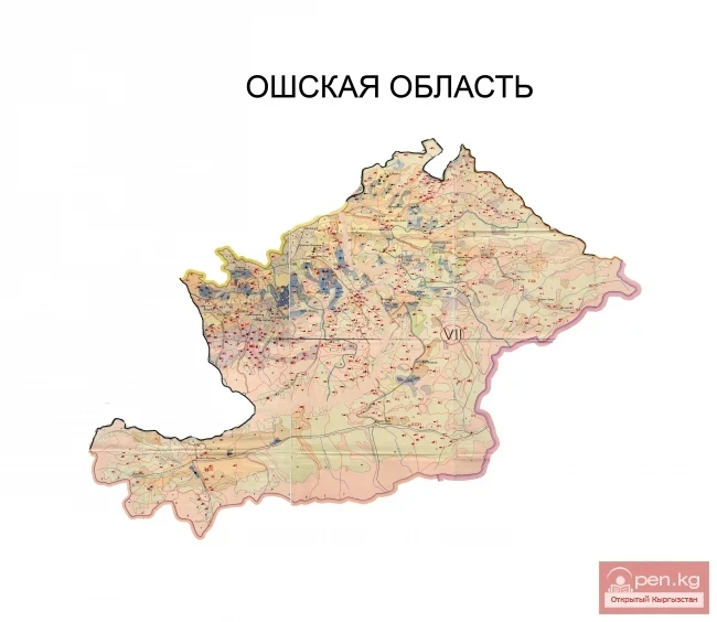
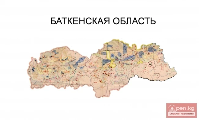
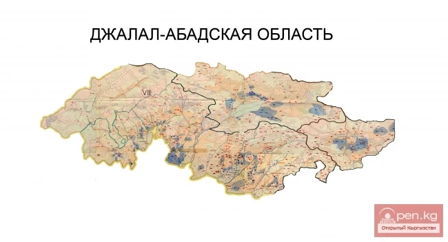
The Naryn Region is located in the southeast of Kyrgyzstan and was first established on November 21, 1939, under the name "Tian Shan Region." On December 30, 1962, the region was dissolved, and its districts came under republican jurisdiction. The Naryn Region was re-established on December 11, 1970. On October 5, 1988, it was merged with the Issyk-Kul Region, and on December 14, 1990, it was renamed back to Naryn Region. The region borders the Issyk-Kul Region to the east, the Chui Region to the north, the Jalal-Abad and Osh Regions to the west, and China to the south. The region includes 5 districts (Ak-Talinsky, At-Bashinsky, Jumgal, Kochkor, and Naryn).
The administrative center of the region and the largest city of Inner Tian Shan is the city of Naryn. The city originated as a military fortification in 1865 at the site of a settlement located on the trade route to Kashgar.
The total area is 45.2 thousand square kilometers, which constitutes 1/4 of the territory of Kyrgyzstan. The population is 249.1 thousand people, accounting for 5.2% of the republic's population.
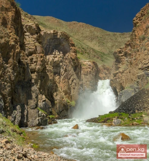
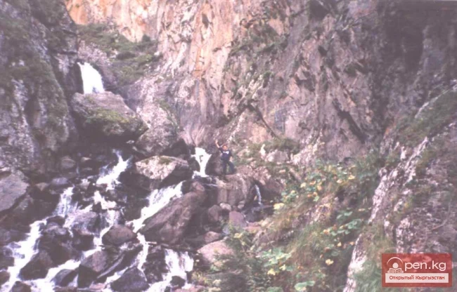
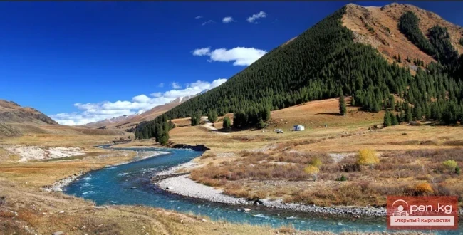
The region is mountainous with a complex relief, located at an altitude of 1500 m above sea level, with about 70% of its territory occupied by mountain ranges. The largest are: Kokshaala (the largest mountain range, 582 km long, separating Kyrgyzstan from China), At-Bashy, Naryn, Jetim, Moldotoo, and Suusamyr. The predominant heights of the ridges are 3000-4000 m, with the highest point being Peak Dankova (5982 m). The mountain ranges are separated by numerous valleys. The largest of these is the Naryn Valley. The Ak-Shiyrak (Chaar-Tash) mountain range divides the Naryn Valley into two: Alabugin and Toguz-Toroza. South of the At-Bashinsky mountain range are the Aksai and Chatyr-Kul valleys, and to the west is the Arpa valley. The mountains: Baybiche-Tuu, Jamantuu, Ak-Shiyrak, and Ala-Myshyk are characterized by steep slopes and short gorges. In the northern part of the region are the Karajorgo, Son-Kul, Kabak, Jumgal ridges, and the intermountain valleys of Jumgal and Kochkor. The rivers of the region flow into the basins of the Syr Darya, Tarim, Chu rivers, and Lake Chatyr-Kul. The Naryn is the largest river, with a length of over 400 km within the region. The main tributaries of the Naryn River are: Chon and Kichi Naryn, On-Archa, At-Bashy, Alabuga, Kök-Irim, Kökömeren. The Chu River is formed by the confluence of the Joon-Aryk and Kochkor rivers. The largest lakes in the region, Son-Kul and Chatyr-Kul, occupy tectonic depressions.


The flora and fauna of the Naryn Region are very diverse. There is a vertical zonation observed on the slopes of the mountains. The belts of mountain deserts and semi-deserts occupy the bottoms of the valleys, their foothills, the riverbanks, and the low-lying parts of the Chatyr-Kul lake basin. The predominant vegetation includes wormwood, with feather grass, saltwort, ephemeral plants, and tugai forests found in some areas. The basin of Son-Kul Lake and some high-altitude valleys belong to the mountain-steppe zone. Here, mountain steppes extend with a predominance of feather grass, couch grass, kobresia, wormwood, and ephemerals. The slopes of the mountains surrounding the valleys belong to the subalpine zone. Subalpine diverse grass meadows are developed on mountain-meadow soils. Forests and shrubs occupy 3% of the region's territory. They are divided into coniferous and tugai forests.
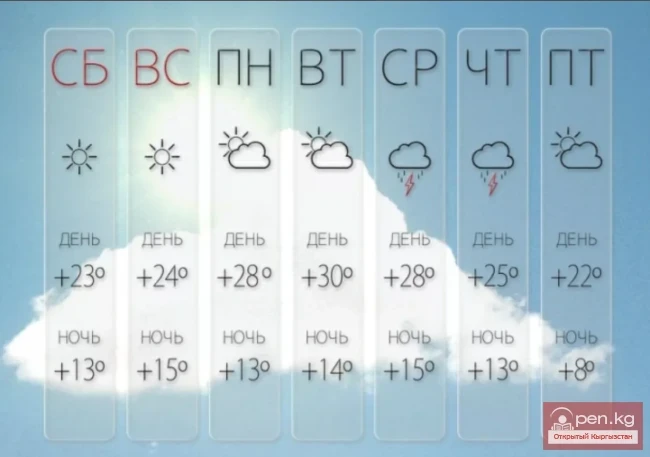
The climate of the region is continental, with cold and prolonged winters. The average January temperature is -15°C. The absolute minimum temperature (-50°C) was recorded in the Ak-Sai valley. In the area of Chatyr-Kul Lake, in the valleys of Ak-Sai, Arpa, and in the basins of Son-Kul, winters are cold, and summers are warm but short. Daily temperature changes are sharp, and frosts can occur even in the summer months. The average annual precipitation in the plains is 200-300 mm, slightly more in the mountains. The period of abundant precipitation occurs in the second half of spring and the first half of summer, when 30-60% of the annual precipitation falls. In the valleys, the amount of precipitation increases from west to east. The snow cover height in the valleys is 15-20 cm, and in the Kochkor valley, due to strong winds, snowfalls are rare.
The nature of the Naryn Region is rich and pristine. Today, there are not many places on earth where one can truly connect with wild, untouched nature, and this fully applies to the Naryn Region, which has great potential for tourism development.
For a long time (during the USSR), most of the territory of the Naryn Region was closed to tourists, which largely helped preserve vast natural complexes in a pristine state. Therefore, there are now great prospects for the development of ecotourism, adventure organization, research expeditions, and special tours. There are also recreational and therapeutic resources, including mineral springs, salt mines in Chon-Tuz, where a popular speleotherapy center is located.
15 kilometers east of the city of Naryn is the remarkably beautiful natural zone of Salkyn-Tor (Cool Place), where the residents of Naryn love to spend their weekends.
On the territory of the region are located: the fortress settlement of Koshoy-Korgon (7-8 centuries), Tash-Rabat - a caravanserai (15th century), the ruins of the fortress of Shirak-bek (10-12 centuries), the mausoleum of Taylak-batyr (19th century), a Stone Age settlement (On-Archa), and other historical monuments.
Cities
Naryn
Kochkor
Natural and ecological complexes:
Upper Naryn
Small Naryn
Architectural monuments
The settlement of Koshoy-Korgon (7-8 centuries)
Tash-Rabat - caravanserai of the 15th century.
Mausoleum of Taylak-batyr (19th century)
Stone Age settlement (On-Archa)
Water resources:
Naryn River
Son-Kul Lake
Chatyr-Kul Lake
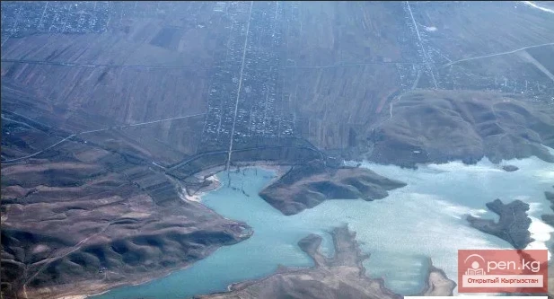
Toktogul Reservoir
Uch-Korgon Reservoir
Kurpsay Reservoir
Sarla-Sa Waterfall
Son-Kul Waterfall
Ala-Myshyk Cave
Reserves:
Naryn State Nature Reserve
Salkyn-Tor National Park
Mountains:
Chon-Tuz Salt Mine
Kokshaala-Tuu and Peak Dankova
Caves of the Kok-Kiya River
Valleys:
Ak-Talaa