Territory, Geography, and Administrative Division of the Kyrgyz Republic
The Kyrgyz Republic occupies the northeastern part of Central Asia. It is located in a desert zone at an altitude ranging from 500 to 7500 meters. It is separated from the seas by vast distances, surrounded by extensive deserts. To the north, west, and southeast of the republic are the sandy "seas" of Kara-Kum, Muyun-Kum, Pribalhashia, and Western China.
Kyrgyzstan is a country of high mountains and sunny valleys. It borders Kazakhstan to the north, China to the southeast and east, Tajikistan to the southwest, and Uzbekistan to the west.
The territory of the Kyrgyz Republic stretches 900 km from west to east and up to 415 km from north to south. In terms of area (198.5 thousand sq. km), Kyrgyzstan ranks 7th among the former Soviet republics (after the Russian Federation, Kazakhstan, Ukraine, Turkmenistan, Uzbekistan, Belarus, slightly behind the latter at 207.6 thousand sq. km), but it is larger than the combined countries of the South Caucasus (186.1 thousand sq. km) and the Baltic republics (174 thousand sq. km).
The territory of Kyrgyzstan could accommodate countries such as Belgium, the Netherlands, Denmark, and Austria combined.
The borders of Kyrgyzstan mainly follow natural boundaries — the crests of high mountain ranges and rivers.
Only in some places do they descend to the plains of the Chui, Talas, and Fergana valleys.
Until 1917, Kyrgyzstan did not have its own territory. Its lands were part of various regions of the Turkestan Territory of the Russian Empire. The southern part of Kyrgyzstan was part of the Fergana region, the Central Tien Shan, the Issyk-Kul basin, and the Chui valley were part of the Jeti-Su region, and the Talas valley was part of the Auliye-Ata district of the Syr Darya region.
The Kyrgyz Autonomous Region, which became part of the RSFSR, consisted of Kyrgyz from the Semirechye and Fergana regions and the mountainous part of the Auliye-Ata district of the Syr Darya region. The Kyrgyz Autonomous Region included the following volosts: from the Andijan district — Karakol, Sary-Suu, Kenkol-Karagyurd, Kugart, Mayli-Sai, Chankent, Aym, Bazar-Kurgan, Massin, Naukat, and Jalal-Abad with the city of Jalal-Abad; from the Namangan district — Arym, Kyzyl-Djar, Kyrk-Uul, Saruy, Susamyr, Chatkal, Kutluk-Seyd, Bagysh, Bayastan, Mustor; from the Fergana district — Yaukesek-Boston, Ichkilik, Naiman, Aravan, and the northern part of Chimiion and Khalmion; from the Kokand district — Laylak and Naigut-Kypchak volosts; from the Osh district — Ak-Djar, Alai, Gulchin, Kara-Tash, Chapkuluk, Yassin, Ak-Burina, Kurshab, Turuk, Naukat, Kashkar-Kishlak, Uzgen, and Osh with the city of Osh; from the Auliye-Ata district of the Syr Darya region — Kurkurev, Karakol, Bau-Terek, Kenkol, Talkanov, Ur-Maryl, Jaiyl, Kara-Baltin, Uch-Kurgan, Dmitriev, Nikolaypol, Orlov, Aleksandrov, and Gorodek volosts; from the Pishpek district — Zagornaya, Belovodskaya, Bystrorechenskaya, Lebedinovskaya, Prigorodnaya, Sukuluk, and Tokmak volosts.
The entire area included the organized region of the Karakol-Naryn district with the following volosts: Borskooun, Jeti-Oguz, Kungay-Aksu, Kurmentin, Ton, Turgen, Tyup, Yessengulov, Naryn, Onarchin, Uchakin, Chash-Tyubin, Chorin, and Sharkratmin.
The total area of the Kyrgyz Autonomous Region was 171,999 sq. versts. The population was 736,834 people:
• Kyrgyz — 63.5%;
• Russians — 16.8%;
• Uzbeks — 15.4%;
• Other nationalities — 4.3%.
Kyrgyz made up a compact majority in the region.
The fourth extraordinary session of the Central Executive Committee of the Turkestan Autonomous Soviet Socialist Republic, held on November 18, 1924, resolved: “For the temporary administration of the Kara-Kyrgyz Autonomous Region, to prepare and convene the Constituent Congress of the Councils of the Kara-Kyrgyz Autonomous Region and to carry out organizational measures, to approve the Revolutionary Committee of the Kara-Kyrgyz Autonomous Region consisting of 17 members.” In the same month, the regional revolutionary committee moved from Tashkent to the city of Pishpek. On November 22, 1924, the Presidium of the regional revolutionary committee approved the borders of the Kara-Kyrgyz Autonomous Region. From that time, the Kyrgyz people gained statehood in the form of an autonomous region.
By the resolution of the Revolutionary Committee of the Kara-Kyrgyz Autonomous Region dated December 8, 1924, the division into districts and volosts was adopted. It was decided to form four districts: Pishpek — 20 volosts with the center in the city of Pishpek; Karakol-Naryn — 16 volosts with the center in the city of Karakol (Przhevalsk); Jalal-Abad — 19 volosts with the center in the city of Jalal-Abad; Osh — 20 volosts with the center in the city of Osh.
The total population in the region, according to the Central Statistical Administration of the Turkestan Republic, was 736,834 people, including in the Pishpek district — 207,182, in Karakol-Naryn — 120,361 people, in Jalal-Abad — 175,198, in Osh — 233,990 people.
At the first Constituent Congress of the Councils of the Kyrgyz Autonomous Region in March 1925, delegates proposed to petition the All-Russian Central Executive Committee for the transformation of the region into the Kyrgyz Autonomous Republic. The Presidium of the regional executive committee raised this issue before the All-Russian Central Executive Committee on December 6, 1925.
The Presidium of the All-Russian Central Executive Committee, taking into account the desire of the people of Kyrgyzstan, its national-territorial compactness, as well as its economic, political, and cultural achievements, adopted a resolution on February 1, 1926, to transform the Kyrgyz Autonomous Region into the Kyrgyz Autonomous Republic, entering it into the RSFSR. This resolution was approved at the III session of the All-Russian Central Executive Committee on November 18, 1926. The session's resolution stated: “Taking into account the overall economic significance of the Kyrgyz Autonomous Region within the RSFSR and the national-territorial compactness (integrity) of Kyrgyzstan, to approve, in accordance with the will of the Kyrgyz working people, the resolution of the Presidium of the All-Russian Central Executive Committee dated February 1, 1926, on the transformation of the Kyrgyz Autonomous Region into the Kyrgyz Autonomous Soviet Socialist Republic, which is a federative part of the RSFSR.
Until the approval of this transformation by the next All-Russian Congress of Councils, to allow the upcoming Congress of the Councils of Kyrgyzstan to elect the Central Executive Committee and organize the republican power apparatus.
Until the Constitution of the Kyrgyz Autonomous Soviet Socialist Republic is approved, in accordance with Article 44 of the Constitution of the RSFSR, to instruct the Presidium of the All-Russian Central Executive Committee to issue a provision on the state structure of the Kyrgyz Autonomous Soviet Socialist Republic.”
Soon, changes were made to the administrative division of Kyrgyzstan. On December 6, 1926, at the request of the Kyrgyz regional executive committee, the Presidium of the All-Russian Central Executive Committee approved the division of the Kyrgyz Autonomous Region into cantons and volosts instead of the existing division into four districts and 72 volosts. Seven cantons were formed: Frunze with five volosts; Chui with three volosts; Talas with five volosts; Karakol with 10 volosts; Naryn with nine volosts; Osh with 12 volosts; and Jalal-Abad with eight volosts.
The first Constituent Congress of the Councils adopted a declaration on the formation of the Kyrgyz Autonomous Soviet Socialist Republic. The declaration proclaimed: “In order to provide the working masses of Kyrgyzstan with even broader opportunities for creative initiative and self-activity in the matter of socialist construction, in accordance with the expressed will of the broad working masses of the Kyrgyz people, the Presidium of the All-Russian Central Executive Committee of the 12th convocation on February 1, 1926, made the decision to transform the Kyrgyz Autonomous Region into the Kyrgyz Autonomous Soviet Socialist Republic.”
After adopting the declaration, the congress elected the Central Executive Committee of the Kyrgyz Autonomous Soviet Socialist Republic.
The transformation of the Kyrgyz Autonomous Region into the Kyrgyz Autonomous Soviet Socialist Republic was an outstanding event in the life of the Kyrgyz people.
After the formation of the Kyrgyz Republic, its territory changed significantly. A number of volosts and settlements (the settlement of Uch-Kurgan, the Sulyukty mines, the Bokso-Isfaney volost) were annexed from Uzbekistan, and from Kazakhstan — the jailoo Kar-Kara in the Karakol area and several others.
As a result of the expansion of borders, the total territory of the Kyrgyz Republic in 1928 amounted to 197,726 km² instead of 195,735.5 km² in 1924 during the national delimitation.
The population of the republic also increased. As of January 1, 1928, the population of Kyrgyzstan was 1,025,745 people (in 1924, it was 736,834 people). The urban population was 121,289 people, or 11.82%, and the rural population was 904,456 people, or 88.18%.
During the formation of the Kyrgyz Republic, there were seven cantons, 52 volosts, 455 rural councils, one settlement council, and six city councils. Partial changes in the administrative division were made throughout 1927; the Osh and Jalal-Abad cantons were merged into one district. The territory of Northern Kyrgyzstan was divided into four cantons — Talas, Frunze, Karakol, and Naryn. In 1927, there were 441 rural councils, seven city councils, and two settlement councils in the republic.
In 1936, the Kyrgyz Autonomous Soviet Socialist Republic was transformed into the Kyrgyz Soviet Socialist Republic.
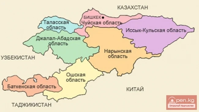
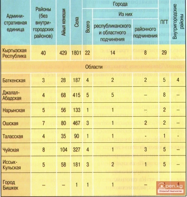
Since 1991, after gaining independence, the Kyrgyz SSR was renamed the Kyrgyz Republic, which consists of seven regions: Batken, Jalal-Abad, Issyk-Kul, Naryn, Osh, Talas, Chui, and the capital city Bishkek. Each region includes districts and cities of regional subordination; districts include cities of district subordination, urban-type settlements, and ayil kenesh, which in turn unite rural settlements.
The Kyrgyz Republic borders the Republic of Kazakhstan to the north, the People's Republic of China to the east and south, and the republics of Uzbekistan and Tajikistan to the west.
Geography and Administrative Division.
Administratively, the territory of Kyrgyzstan is divided into 7 regions:
Batken Region,
Jalal-Abad Region,
Issyk-Kul Region,
Naryn Region,
Osh Region,
Talas Region,
Chui Region.
Each region is subdivided into districts. There are 40 administrative districts and 22 cities in the republic. The head of the region is the governor. The head of the district is the akim. The capital of the republic is the city of Bishkek.
In 1926, the population of Kyrgyzstan was no more than 1 million people. By 1980, the population of the republic had increased more than fourfold, while the overall population of the Soviet Union increased by 1.6 times. As of January 1, 1985, there were 3,967.5 thousand people living here. By 2012, the population reached 5,551.9 million people.
In the future, there is a possibility of changing the administrative-territorial division of Kyrgyzstan, abolishing regions, consolidating districts, and transitioning to a three-tier subordination level (ayil okmotu — districts — republic). The territory of the republic will be divided into separate economic regions.
In the Issyk-Kul region, due to the development of tourism, large tourist and resort zones will be formed, and the mining industry (Kumtor) will further develop. In the Jalal-Abad region, in addition to the existing hydropower plants (Uchkurghan, Shamal-Dysay, Tashkumyr, Toktogul), the Kambarat-1 and Kambarat-2 hydropower plants will be built, which will increase electricity production and allow for its export to Pakistan and China. The construction of the Tashkumyr cement-asbestos plant and the "Crystal" plant, along with the development of gold ore deposits, will turn this region into a major industrial zone. Naryn and Talas regions will specialize in livestock breeding according to their natural and economic conditions. In the Osh, Jalal-Abad, and Batken regions, there are opportunities for further development of agriculture, cotton growing, and light industry. The completion of the construction and reconstruction of roads — Bishkek - Osh, Osh - Batken - Isfara, Tashkumyr - Kerben - Chatkal, Bishkek - Torugart, Osh - Sary-Tash - Irkeshtam - Kashgar, as well as the construction of railways Kashgar - Torugart - Osh - Andijan and Jalal-Abad - Karakeche - Balykchy will not only firmly connect the economic regions of Northern and Southern Kyrgyzstan but also ensure connectivity with China, Russia, Tajikistan, Kazakhstan, and Afghanistan. This will open up opportunities for broad integration of the road network not only into the regional transport infrastructure but also into the global one.
Administrative-Territorial Division of Kyrgyzstan

