Kyrgyzstan: A Country of Heavenly Lakes
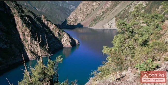
Kyrgyzstan can confidently be called a country of heavenly lakes, as there are about 2,000 of them in the republic. The water surface of the lakes covers almost 7,000 square kilometers. Here you can find giant lakes, whose water volume can rival that of some seas, as well as tiny lakes that are so small they are not even marked on topographic maps.
Kyrgyzstan has 1,923 lakes with a total mirror area of 6,836 square kilometers. The lake area of the territory is 3.4%. Only 16 lakes have an area of more than 1 square kilometer. Most of the lakes are small. 84% of all existing lakes in Kyrgyzstan are located in the mountainous zone, at altitudes of 3,000-4,000 meters above sea level.
Lakes can have various origins: tectonic, dammed, glacial, and karst. There are giant lakes that can compete with some seas in terms of water volume and depth, as well as temporary small lakes that, due to their miniature size and short lifespan, are not even marked on topographic maps.
Among the lakes of Kyrgyzstan, several genuine natural wonders can be named. These include Issyk-Kul, Son-Kul, Chatyr-Kul, Sary-Chelek, and Mercbakhara.
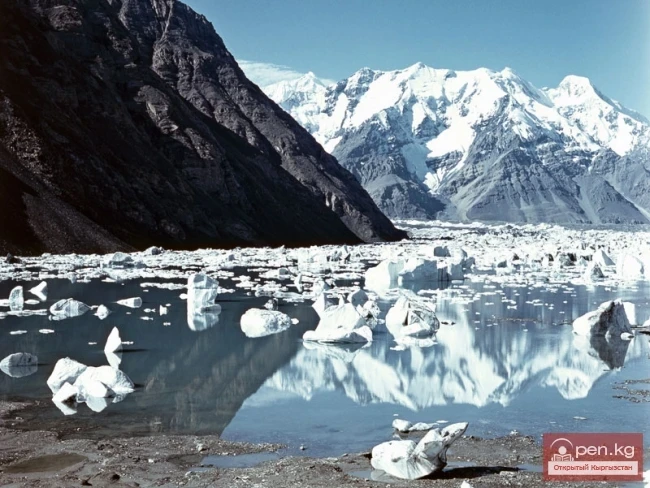
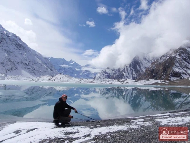
The large number and diversity of lakes allow for the creation of specific tourism products in each case. On Issyk-Kul, this includes cruises on boats, sailing, windsurfing, water skiing, etc. Son-Kul is primarily known for fishing. Chatyr-Kul is famous for observing rare birds. Sary-Chelek offers walks and surrounding landscapes. Mercbakhara features an arctic climate, floating icebergs, and the annual phenomenon of shedding. Lakes, just like rivers, have limitless potential for creating ideas and tours such as "In the Land of Heavenly Lakes," "Across the Lakes of Kyrgyzstan," etc.
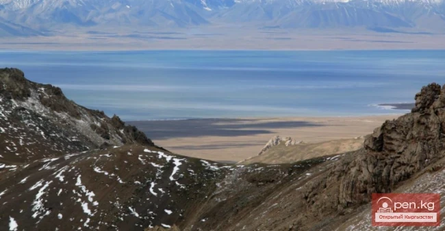
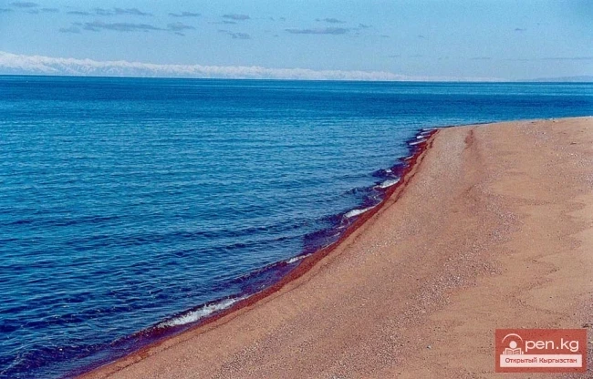
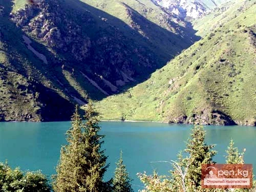
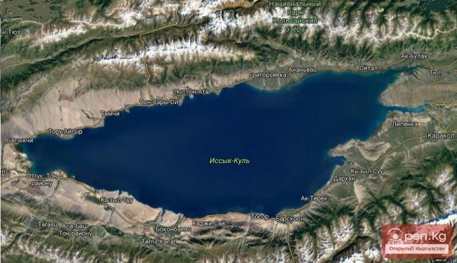
The Issyk-Kul Lake, justly called a heavenly sea, the pearl of the Tien Shan, an aquamarine in a silver frame of mountains, has various epithets. Its name translates from Kyrgyz as "hot lake," and from ancient Turkic as sacred, revered, and protected. This name was first mentioned in an anonymous geographical work of the 10th century, "The Boundaries of the World." However, at different times, the lake had other names: "Temir-Nor" — iron lake, "Tuzkul-Nor" — salty, "Zhe-Khai" — warm, and so on.
Issyk-Kul is located at an altitude of 1,607 m above sea level and covers an area of 6,206 square kilometers. The maximum depth is 668 m. About 80 rivers flow into the lake, but none flow out.

The water in the lake is salty, containing 5.9 g of various salts per liter. Research has shown that in a liter of fresh water flowing into Issyk-Kul, there are between 0.08 to 0.38 g of salts. This concentration is not perceptible to taste, which is why such water is considered fresh. However, if we take the total volume of water brought by "fresh" rivers into the lake, it turns out that Issyk-Kul contains about 10 billion tons of various salts.
Moreover, every year, a layer of water more than 80 cm thick evaporates from the lake's surface, and the salts contained in this water remain in the lake, accumulating year after year.
In terms of transparency, the water of Issyk-Kul in open deep-water areas is no different from that of the sea and ocean. Near the shores in summer, it becomes murkier due to waves eroding the banks and bringing glacial water from rivers. A white disk lowered into the water in the open part of the lake can be seen at depths of up to 20 m.
Thanks to its high transparency, the water of Issyk-Kul acquires an exceptional blueness, surpassing the saturation of the color of such a well-known lake as Lake Geneva by 3-4 times.
Issyk-Kul is located in a desert zone, in the center of the vast Euro-Asian continent, and is thousands of kilometers away from the sea coasts. The huge ridges surrounding Issyk-Kul reliably protect it from the scorching breath of deserts. Because of this, there exists a local marine climate in the Issyk-Kul region. There is no exhausting summer heat, and there are no severe frosts; the air is cool and clean, with plenty of sunshine. The summer in the basin is long and warm.
The mountains surrounding the lake to the south are known as Terskey Alatau, meaning "standing against the sun," while the mountains along the northern shore are called Kungey Alatau, meaning sunny. The mountain barriers create a closed basin that is uninterrupted, and only in the extreme west and east are the mountain frames cut by narrow river valleys, through which the Issyk-Kul region connects with the "outside world."
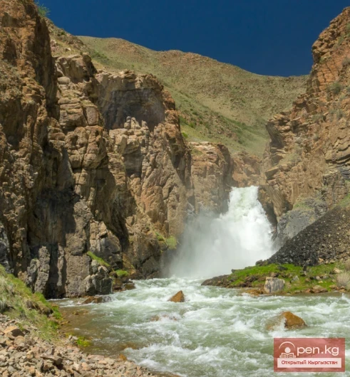
The basin of the lake stretches more than 250 km from west to east and is 70 km wide. Magnificent picturesque gorges cut the edges of the basin. There are narrow canyons, wide forested valleys, turbulent rivers, streams with crystal-clear water, noisy waterfalls, and forest glades.
Winds on Issyk-Kul are a common phenomenon. The waves can start unexpectedly in clear weather, and then, within minutes, the calm surface of the lake transforms, dark purple waves crash onto the shores and onto the boats of unsuspecting fishermen.
Winds predominantly blow from the west ("ulan") and from the east ("santash") along the lake. Additionally, each section of the shore has its own local breezes. These are recurring winds that arise from uneven heating and cooling of the air over land and water. During the day, they blow from the lake, and at night — from the land, which is why they are called "mariner" and "mountaineer."
Studies have shown that the beaches of Sochi on the Black Sea are the most "crowded," with less than one square meter of pebble beach (not sandy like Issyk-Kul) per vacationer. Such "density" of vacationers is noted not only in Sochi but also in other resort areas along the Black Sea coast of Crimea and the Caucasus.

And the first-class Issyk-Kul beaches can "allocate" each vacationer about one hundred times more "territory," combined with crystal-clear water, mountain-sea air, and high ultraviolet radiation.
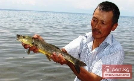
For fishing enthusiasts, summer at Issyk-Kul is a paradise: just keep threading bait and casting lines. All day long, from morning until late at night, the Issyk-Kul roach — a small, tender, tasty fish — bites. Catching roach is not difficult; even the most inexperienced fisherman can pull out this silver fish measuring 12-15 cm on the first try.
However, there is also plenty of large fish in Issyk-Kul: carp, osman, common carp, marinka, and trout, which were brought here from Lake Sevan.
The best time for swimming in Issyk-Kul is July and August. During this time, the water in the areas adjacent to Rybachy, Cholpon-Ata, Korumdy, Tamga, and in the Tyup and Jergalan bays warms up particularly well. In some years, in July and August, the water here has warmed up to 25-28°... In the coldest months — January and February — when the air temperature drops to -5, -9°, the water temperature in the lake drops to +4.8°, and at depths of 200 m and below — to +4°. This is why Issyk-Kul does not freeze.
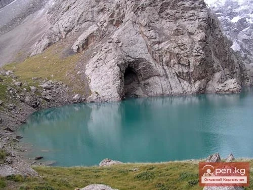
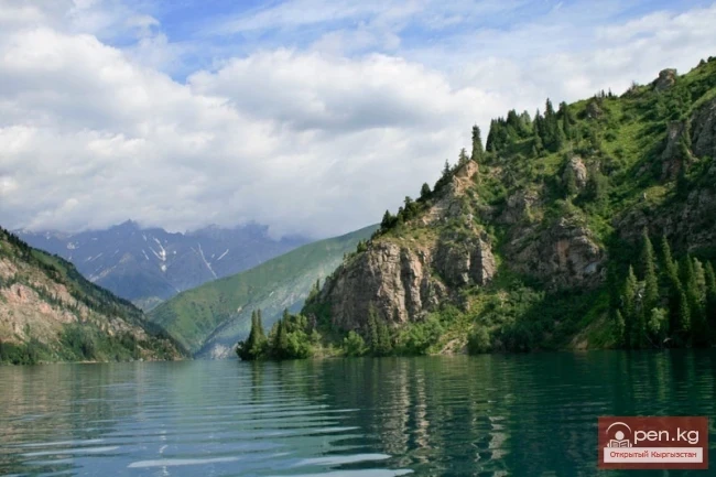
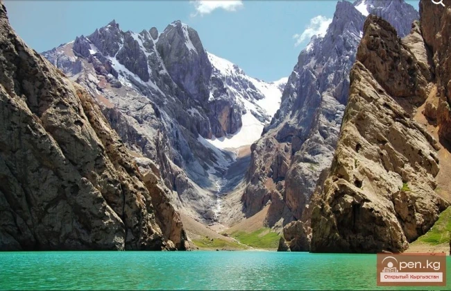
Sary-Chelek Lake, unique in its beauty and richness, can rival Lake Ritsa and the lakes of Switzerland. It is located at an altitude of 1,874 m above sea level, on the southeastern slope of the Chatkal Range. Its length is 8 km, and its width ranges from 300 m to 4 km. Sary-Chelek is the second deepest lake (244 m) in Kyrgyzstan after Issyk-Kul, with a volume of 456 million cubic meters of water.
Since 1959, the Sary-Chelek Nature Reserve has been established in this area. Its flora includes about 1,000 species, and its fauna includes more than 30 species of wild animals. The state reserve is home to over 150 species of birds.

The reserves of fresh water in Sary-Chelek Lake would be enough to provide drinking water for almost a third of humanity for a year.
At the northern slopes of the Fergana Range lies the beautiful Kara-Suu Lake. Geologists believe it was formed as a result of a riverbed collapse during the period of mountain formation. The lake is divided into two small lakes. The locals named the upper one "Kapka-Tash," and the lower one — "Kara-Suu." Marinka and osman fish are found here. The surroundings of the lake are very picturesque.

On the southern slopes of the Chatkal Range, at an altitude of 2,600 m above sea level, lies the high-altitude Kugala Lake (Kek-Ala). It is believed that in ancient geological epochs, a section of the Earth's crust sank here. The depression filled with water, forming a lake. It is 2 km long, over 1 km wide, and 130 m deep.
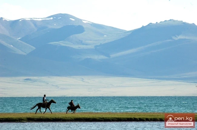
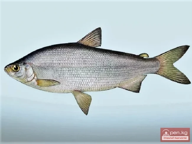
The Son-Kul Lake is uniquely situated among mountain ranges rising above 3,000 m above sea level. Its mirror area is 275 square kilometers, with a maximum depth of 16.1 m and a volume of 2.82 cubic kilometers. It is of tectonic origin and filled with fresh water. Due to the harsh climate, the lake was fishless until 1959. Thanks to the efforts of Kyrgyz ichthyologists, Son-Kul has now become an important fishing zone, and since 1975, commercial fishing of whitefish has been allowed here.

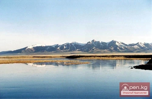
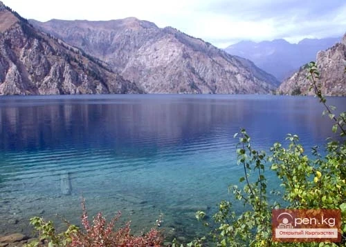
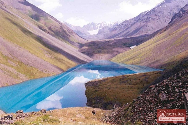
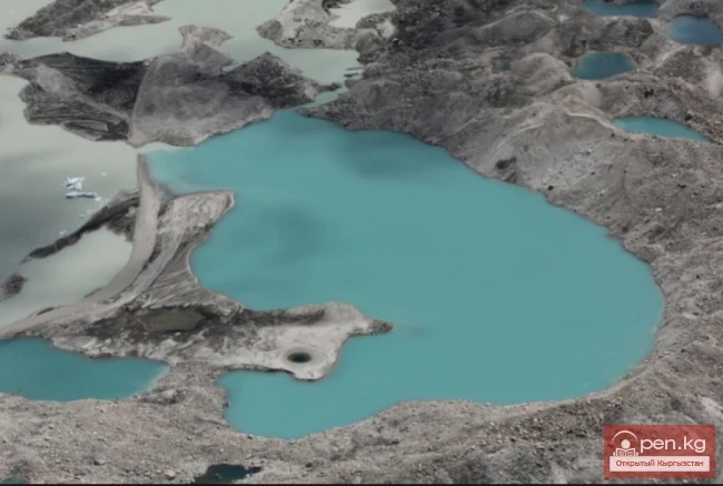
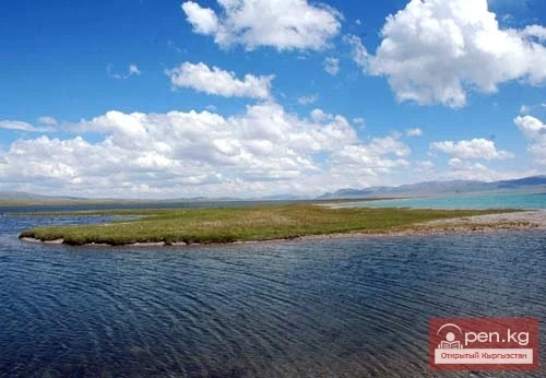
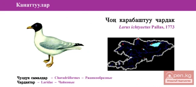
The highest lake in the republic is Chatyr-Kul. It is located at an altitude of 3,530 m above sea level. The area of the lake is 175 square kilometers, with prevailing depths of 2-3 m. There are no fish in Chatyr-Kul due to the low temperature.
[img|Chatyr-Kul Lake]https://open.kg/uploads/posts/2014-01/1391097939_images.webp[/img]
"Rivers are the lifeblood, through which, like blood in a living organism, water flows," said the ancient Chinese philosopher Li.
"Rivers are messengers of heaven," asserted the immortal ancient Greek poet Homer in his works.
The word "river" speaks volumes to the heart of every person! For some, it evokes memories of a wide water surface traversed by steamships. Others recall a noisy, talkative stream, always rushing somewhere, or a flat river with whirlpools, backwaters, and sandy-pebbly bars.
Moisture, soaked by rain on land, flows down from high places to lower ones under the influence of gravity. Individual streams merge to form brooks, which in turn give rise to rivers.
Rivers collect tribute from their tributaries and grow in size. After a short or long journey, they reach the ocean or sea, where their flow ends.
The life of rivers is unique and unrepeatable. Each has its own history, character, and fate. And there are no rivers in Nature that are alike or exactly copy each other. Each river is an original, unique creation of nature.
There are over forty thousand rivers and streams in Kyrgyzstan. All of them are characterized by steep gradients, high water yield, and do not freeze in winter due to their fast flow. Their total length is about 150,000 km, and the annual runoff is 47 cubic kilometers.
More than half (55.3%) of Kyrgyzstan's territory belongs to the area forming the basin of the Syr Darya River. Only one river, Kyzyl-Su, in the southwest of the republic (3.9%) belongs to the basin of the Amu Darya River. The southeastern part of the republic's territory (12.9%) is the area forming the runoff of the main tributaries of the Tarim River — the water artery of Western China.

Rivers, starting from glacial sources, along their entire length, along with adjacent overgrown banks, floodplains, and numerous inhabitants, represent boundless tourist resources for forming various programs: rafting, kayaking, fishing, various types of recreation, organizing specialized tours, such as wildlife and bird watching, adventure tours, and others that are increasingly in demand in global tourist markets.
Rivers are the creators of canyons, a special type of landscape, based on which a new direction of adventure tourism, canyoning, is developing.
The rivers with the greatest tourism resources are: Naryn, Chuy, Kekemeren, Sary-Jaz, Chatkal, and others.
The most water-rich and fastest river in Kyrgyzstan is Naryn. Its length within Kyrgyzstan is 535 km. More than 600 large and small rivers flow into the Naryn.
In terms of hydroelectric resource reserves, Naryn, although it does not appear impressive externally, ranks second only to six rivers in the CIS. This is due to the height difference and flow speed. There are places where rocks compress the flow into a throat no more than a dozen meters wide. A multi-ton boulder caught in the rapids glides across the surface like a chip — such is the fierce power of this offspring of the Tien Shan glaciers.

The average slope of the main flow of the Naryn exceeds 3 m per 1 km. This is 43 times greater than the average slope of the Volga (7 cm per km) and 14 times greater than the average slope of the Angara.
The main river (The Gevera of Kyrgyzstan — Chuy). It is formed in the Kochkor depression from the confluence of the rivers Joo-Aryk and Kochkor. Bypassing Issyk-Kul Lake, Chuy flows into the valley of the same name. Here, its largest tributary, Chon-Kemin, and several small rivers: Kyzylsu, Shamsi, Kegety, Issyk-Ata, Alamedin, Ala-Archa, Ak-Suu with their tributaries flow into it.
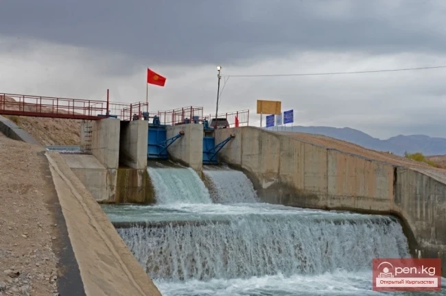
The Ortok-Tokoy Reservoir has been built on the Chuy River. At the Chuy cliffs, it is dammed by the Chuy Dam — the first hydroengineering project in the Chuy Valley.
The waters of Chuy are used for irrigation through the BChK (Big Chuy Canal) — an outstanding hydraulic structure of Kyrgyzstan from the 1940s. A cascade of hydroelectric stations operates on the canal.

The writer V. Vitkovich described this river in his book "With You in Kyrgyzstan": “The river Chuy, which gave its name to the Chuy Valley, is an amazing river: it has no mouth. It begins in the Tien Shan mountains, at an altitude of almost five thousand meters. Jumping from rocky ledge to ledge, merging with other streams, it diligently makes its way to the mountain lake Issyk-Kul. Finally, having reached the Issyk-Kul valley, it rushes straight to the lake. But instead of flowing into it, a little short of the lake, Chuy, as if frightened, darted aside and breaks through the giant ridges into the steppe expanse. Here, the water-rich river irrigates part of the vast Chuy Valley — spreading out into canals.”
Many rivers in Kyrgyzstan have underground feeding. The river Red in the Chuy Valley has the largest underground feeding. Its origin is solely due to the drainage of underground waters.
From the confluence of the rivers Karakol and Uch-Koshoy, the Talas River is formed, with a length of 102 km within Kyrgyzstan. Its waters are used for irrigation, and a small part is lost in the sands.

The Chatkal River, which flows from the southwestern slopes of the Talas Range, is fed by melting snow and glaciers. Flowing through the Chatkal Valley, it receives three major tributaries, then flows into Uzbekistan, forming the Chirchik River.
The reserves of fresh underground water are of great importance for the economy of the republic. To date, in Kyrgyzstan, operational reserves of underground water for irrigation have been explored and approved for 19 deposits, with 1,056 wells in use.
There are two thousand lakes in Kyrgyzstan, but that is not enough. People create artificial reservoirs, new and new lakes-reservoirs. In addition to energy needs, these man-made lakes — giant savings of precious water in Central Asia — are designed to solve the problem of dry years, providing water for agriculture not only in Kyrgyzstan but also in neighboring republics.
The reservoir of the Toktogul Hydroelectric Power Station is the second largest body of water in Kyrgyzstan after Issyk-Kul. Created by human hands, it holds 19.5 cubic kilometers of water and is 60-70 km long.
The main hydraulic structure of the Talas Valley is the Kirov Reservoir with a useful water volume of up to 550 million cubic meters.
Among the hills and depressions of the terrain in southern Kyrgyzstan, the Naiman and Toktogul reservoirs accumulate water for irrigation. The latter was the first in world practice to have its bottom lined with polyethylene film.
From October to May, the Orto-Tokoy Reservoir accumulates 400-500 million cubic meters of water, releasing water in the summer for the irrigation of lands in the Chuy Valley through numerous canals and branches of the irrigation network.