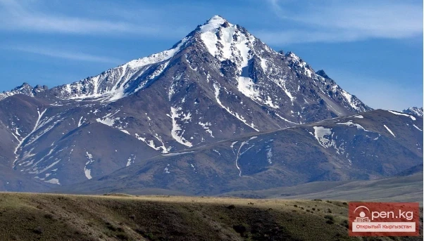
Talassky Ala-Too
A mountain range located in the Western Tien Shan system. Most of it is situated in Kyrgyzstan, with a part in southern Kazakhstan. This range separates the Talas Valley from other ranges and valleys of the Western Tien Shan and the western part of the so-called Inner Tien Shan. The length of Talassky Ala-Too is about 270 km, with a width of 40 km. The average height (above sea level) is 3930 m, with the highest peak being 4488 m – Mount Manas.
The Talas basin is bounded to the north by the Kyrgyz Range and to the south by the Talas Range. The river is formed by the confluence of Uchkochoi and Karakol. Below the confluence, the Talas flows for almost 100 km through an intermountain valley, which reaches a width of up to 15 km in places.
In this section, the largest tributaries (Kolba, Beshtash, Urmaral, Kumyshtak, Karabura) flow into the river from the left.

In the territory of the intermountain basin, the channel of the Talas often splits into branches, separated by islands.
The fragmentation of the channel is especially noticeable where the river exits the gorge and turns north, bypassing the western end of the Kyrgyz Range. Further, the Talas disappears in the flat areas, not reaching the Chu River, of which it was once a tributary.
Three rivers originating on the northern slopes of Talassky Alatau – Aksai, Koksai, and Kurkureu (sometimes referred to as Kyurkuresuu) – are right tributaries of the Ters River, which, after the confluence of the last tributary, is called Assa.

The Talassky Alatau separates the Talas and Assa rivers from the Chirchik basin, and its western end divides the basins of Assa and Aris.
The high-altitude zone of Talassky Alatau has a typical alpine appearance: rocky relief, narrow, jagged peaks of the ridge, covered in places with ice and firn, and steep slopes (up to 60-70°).
The northern spurs of the range, descending into the Talas Valley (usually in a meridional direction), initially have an alpine appearance, but closer to Talas, they acquire softer forms with grassy slopes, some of which are dissected by a dense network of short, shallow, but quite steep ravines.
The upper part of the Talas Range is characterized by massive outcrops of bedrock, leading to extensive scree. Above 3500 m, there are cirque depressions with relatively gentle walls, with bottoms filled with coarse debris. Most of the glaciers on the northern slope of Talassky Alatau are concentrated in these depressions. In the pre-ridge part of the range, spurs are well developed.

A total of 281 glaciers have been registered in the basins of Talas and Assa, two-thirds of which are located in the described area; however, many are extremely small. Their total area is 121 km². Only 8 glaciers extend more than 3 km in length, while the length of 164 glaciers does not exceed 1 km. The largest glacier in this area is "Around the World." Its length is 3.6 kilometers, and its total area is 6.8 km².