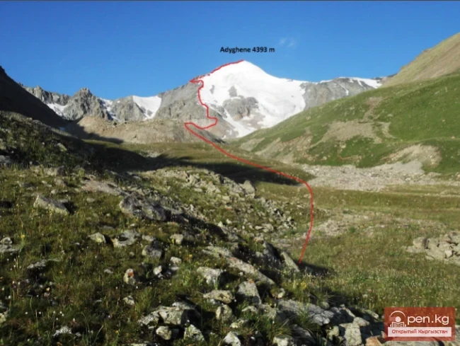
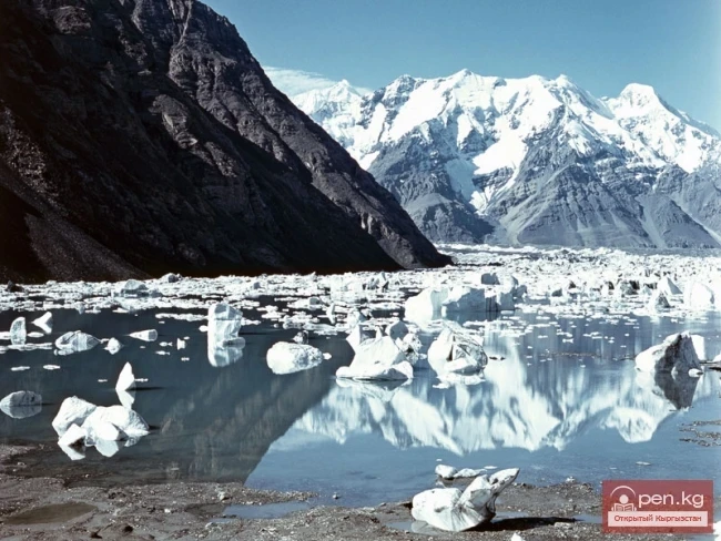
Glacier Golubina

admin Glaciers
VK X OK WhatsApp Telegram
Golubina Glacier

Golubina Glacier


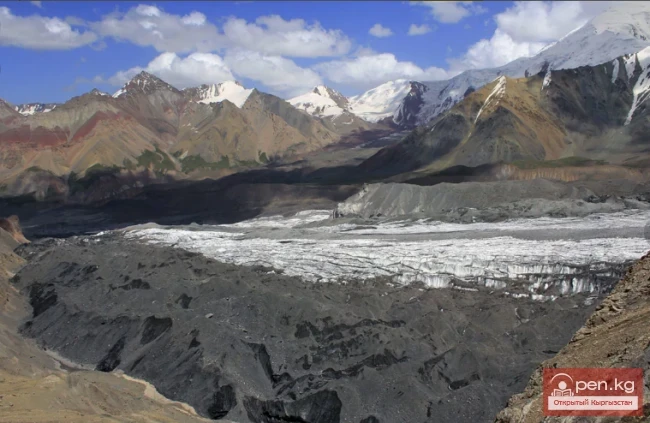
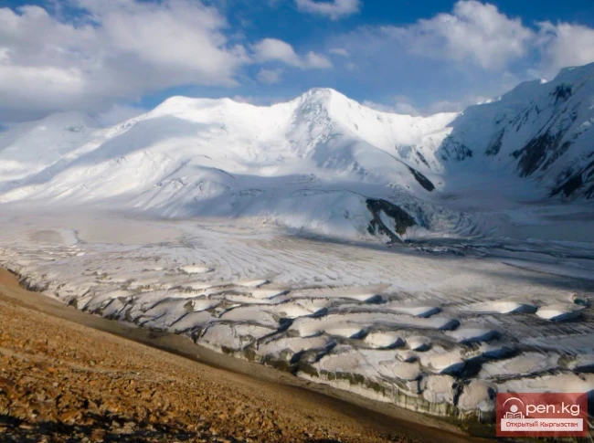
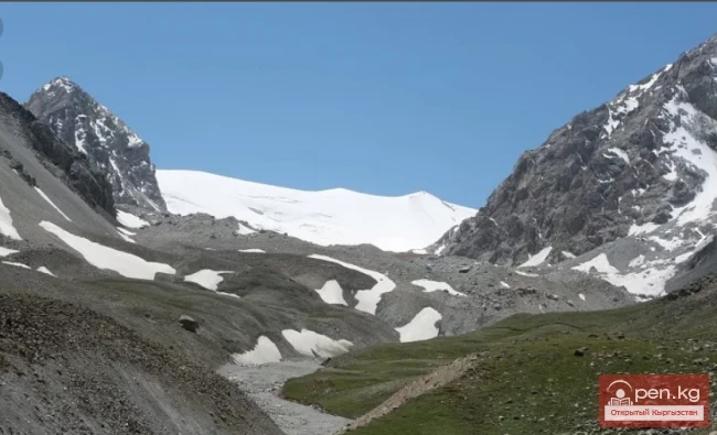
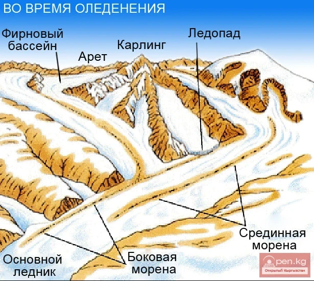
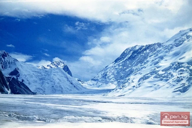
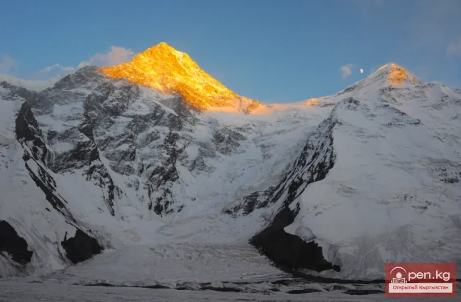
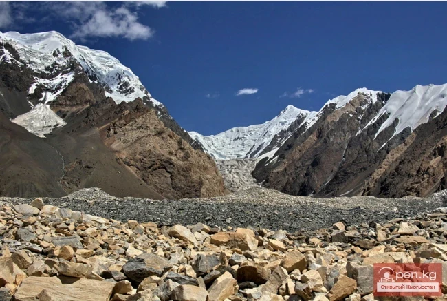
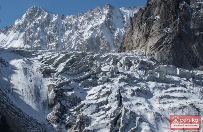
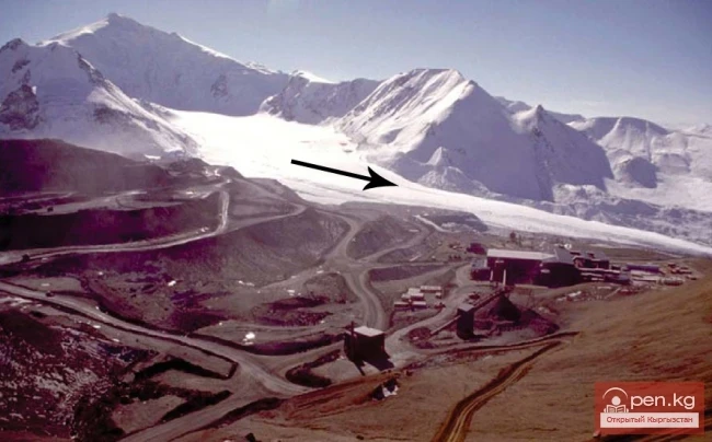
The Golubina Glacier is of the valley type and is located on the northern slope of the Kyrgyz Ala-Too range, in the basin of the Ala-Archa River (a left tributary of the Chu River). With an area of 6.2 km², its length exceeds 5 km. The highest point of the glacier basin is at an altitude of 4220 m, and the firn line is at an altitude of 3860 m. The firn basin of the glacier is a vast hollow, approximately 3 km in diameter, surrounded by snow-covered rocks. At the exit from the firn basin, the glacier forms an extensive icefall zone, where the height difference reaches 100-150 m. The tongue of the glacier, 0.5 km wide, ends with a steep slope at an altitude of 3400 m. Along the glacier tongue, there are ridges of lateral moraines, and there are few moraine deposits on the surface of the glacier.

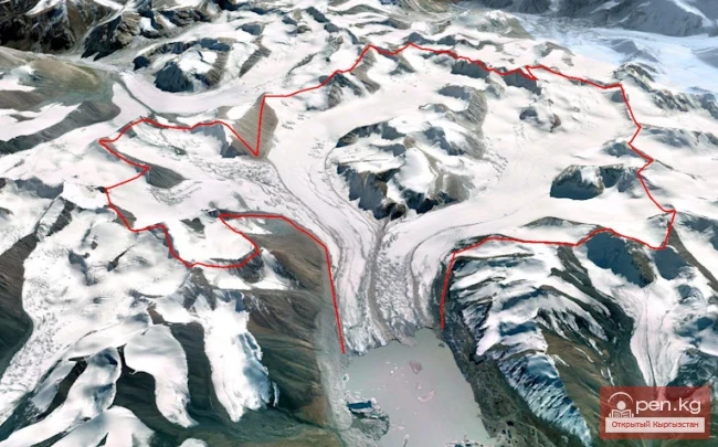
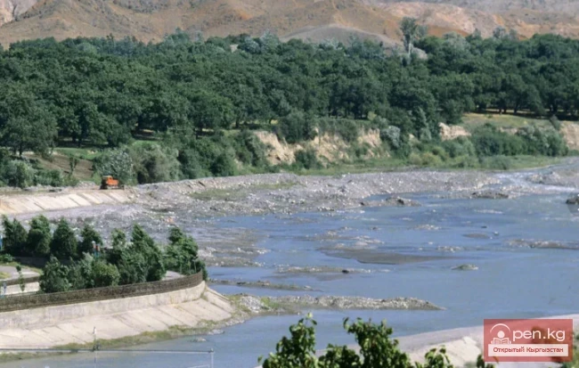
Data from the Central Asian Institute of Applied Geosciences indicate a significant reduction in the area of the Golubina Glacier in the Ala-Archa Gorge from 1861 to 2015; for instance, from 1917 to 1961, the Golubina Glacier retreated by almost 1 km. In recent years, the Golubina Glacier has retreated another 200 meters.
Golubina Glacier

Glaciers are an important source of fresh water in Central Asia, as maximum glacial runoff occurs in the summer months when precipitation is minimal and water demand is at its peak. Many studies have focused on the changes in the area of the Tien Shan glaciers; however, to assess river runoff and the impact of climate change, data on changes in ice mass are necessary. Despite the importance of such studies, similar work has only been completed for a small number of glaciers. Mass balance estimates using geodetic methods can complement and extend existing series of direct measurements on glaciers. This study assessed changes in the area and mass of glaciers located in the Ala-Archa valley in the Kyrgyz Tien Shan using stereo images from the Corona satellite from 1964 and 1971, ASTER stereo images from 2012, the SRTM digital elevation model, and other optical data, including LANDSAT ETM+ and RapidEye. Additionally, modeling of ice thickness was performed based on shear stress at the bedrock and the surface topography of the glaciers. The results showed that from 1964 to 2010, the glaciers continuously shrank and lost 18.3±5.0% of their total area. The average mass balance was −0.45±0.27 m w.e. per year for the period from 1964 to 1999 and −0.42±0.66 m w.e. per year from 1999 to 2012. For the Golubina Glacier, a slight mass accumulation was recorded from 1964 to 1971, and a slowdown in mass loss was observed from 1999 to 2012. These results are consistent with existing data from direct mass balance measurements conducted from 1962 to 1994 and from 2010 onwards. As of 2000, the total volume of ice was 1.56±0.47 km³. Thus, if the mass of ice continues to decrease at the same rate, the glaciers in the study area will completely melt by 2100.
VK X OK WhatsApp Telegram

Read also:

Aksai Glacier

Aksai Glacier

Ak-Sai Glacier The glacier is located 40 km from Bishkek in the picturesque Ala-Archa gorge at an...

Lenin Glacier

Lenin Glacier

Lenin Glacier — a mountain valley glacier on the northern slope of the Zaalai Range (Pamirs), in...

Mushketov Glacier

Mushketov Glacier

Mushketov Glacier A valley tree-like glacier in the Central Tien Shan in Kyrgyzstan (Issyk-Kul...

Nura Glacier

Nura Glacier

The Nura Glacier is located in the basin of the Eastern Kyzylsu River A large complex valley...

Kainyndy Glacier

Kainyndy Glacier

Kainy Between Kokshaal-Tau and Kainy-Katta lies the powerful Kuyakap Glacier, and between...

Kolpakovsky Glacier

Kolpakovsky Glacier

The Kolpakovsky Glacier is the most significant glacier of the Terkey-Ala-Too range. Its length is...

Semenov Glacier

Semenov Glacier

Semenov Glacier - the basin of the upper reaches of the Sarydjaz River. This basin includes the...

Petrov Glacier

Petrov Glacier

Petrov Glacier - a glacier in Central Tien Shan On a small area of the Ak-Shiyrak mountain range,...

Glacier Archa-Bashi

Glacier Archa-Bashi

Archa-Bashi Glacier on the Alai Range The Archa-Bashi Glacier is large and dendritic, located at...

Nalivkin Glacier

Nalivkin Glacier

Nalivkin Glacier. One of the right tributaries of the largest glacier in Pamir, Fedchenko Glacier....

Glaciers of Kyrgyzstan

Glaciers of Kyrgyzstan

The territory of Kyrgyzstan is predominantly mountainous, with peaks almost everywhere reaching...

Abramov Glacier

Abramov Glacier

Slow Retreat of the Abramov Glacier The Abramov Glacier in the Pamir-Alai mountains is one of the...

Glacier Kyzylsu

Glacier Kyzylsu

Kyzylsu - Red Water The Kyzylsu Glacier (often referred to as the Eastern Kyzylsu) is a complex...

The Peak of Gorky

The Peak of Gorky

Pik Gorkogo (6050 m) - located in the Central Tien Shan in the Tengri-Tag ridge. The southern...

Glacier Starlet

Glacier Starlet

Zvezdochka The Zvezdochka Glacier flows into the Inylchek Glacier, 40 km from the tongue of the...

The Ridge of Inylchektau

The Ridge of Inylchektau

Inylchektau A mountain range in the Central Tien Shan in Kyrgyzstan. It is located in the basin of...

"Ala-Archa Zone"

"Ala-Archa Zone"

Ala-Archa Zone is located 30 km south of Bishkek in the central part of the Kyrgyz Ala-Too range...

Glacier Koy-Kap

Glacier Koy-Kap

Koy-Kap - Glacier in the Khan-Tengri Massif The Kaindy Ridge, which separates the valleys of the...

Komarov Glacier

Komarov Glacier

Komarov Glacier (Ak-Sai), Kokshaalsky Ridge The first survey of the glaciation in this area was...

Ak-Sai Waterfall

Ak-Sai Waterfall

Bright and Colorful Ak-Sai. The height of the waterfall is 25-30 m (2700 m above sea level). Chui...

Peak Adygene

Peak Adygene

Peak Adygene. It is located at the top of the gorge of the same name on the northern slope of the...

Glacier Korzhenevskogo

Glacier Korzhenevskogo

The Greatest Glacier of Pamir On August 22, 1953, eight climbers from the Pamir expedition of the...

Peak Karakol

Peak Karakol

Peak Karakol (5281 m) Located in the Oguz Bashi massif on the southern shore of Lake Issyk-Kul;...

Upper Naryn

Upper Naryn

Upper Naryn includes the upper part of the Naryn River basin from the vicinity of the town of...

Kara-Archa Waterfall

Kara-Archa Waterfall

Kara-Archa Waterfall - left tributary of Kegety (Chui region) Coordinates: 42.504977, 75.069273...

Meridional Ridge

Meridional Ridge

Meridional Ridge The main nodal uplift of the Central Tien Shan on the border of Kyrgyzstan and...

Peak Djigit

Peak Djigit

Peak Djigit - height 5170 meters. It is located in the main watershed ridge of the Terskey Alatau...

Rivers of Kyrgyzstan

Rivers of Kyrgyzstan

The formation of runoff and the hydrographic network in the territory of Kyrgyzstan is greatly...

Isfara River

Isfara River

Isfará — a river of the Syr Darya basin The river basin encompasses the Isfara and Kanibadam...

Lakes of Kyrgyzstan

Lakes of Kyrgyzstan

In the territory of Kyrgyzstan, there are 750 lakes, reservoirs, and small ponds with a total area...

Write a comment: