Scientists of Kyrgyzstan
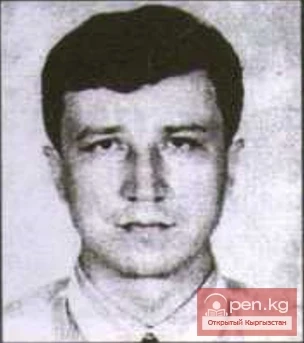
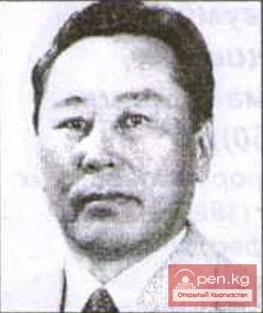
Tursunov Kubanychbek Janibekovich
Tursunov Kubanychbek Janibekovich (1960), Doctor of Technical Sciences (1993) Kyrgyz. Born in the city of Naryn, Naryn region.
20.11.2018, 20:28
Tursunov Kubanychbek Janibekovich (1960), Doctor of Technical Sciences (1993) Kyrgyz. Born in the city of Naryn, Naryn region.
Hero of the Soviet Union Gadelshin Khamit Gabdullovich Senior radio telegraph operator of the 1449th separate communications company of the 31st rifle division of the 46th army of the Steppe Front, sergeant. Born on July 10, 1923, in the village of Aitovo, Bichbulyak district of Bashkiria, in a peasant family. Tatar. Member of the VKP(b)/CPSU since 1942. Completed 7 grades. Drafted into the Red Army in August 1941 by the Frunze city military commissariat of the Kyrgyz SSR. Completed radio
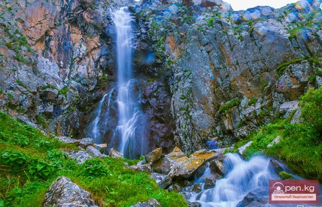
Burgan-Suu Gorge Waterfall A hike to the waterfall will take about two days, as the gorge leading to the waterfall is long. The starting point for the hike is the village of Zharkonbaev (a little east of the village of Ananyev). If there is transport available, you can reach the village of Karoool-Debe (at the beginning of the gorge). From there, you can either walk or ride a horse. Along the way, you will need to cross the main river several times (on the General Staff map, it is called, like
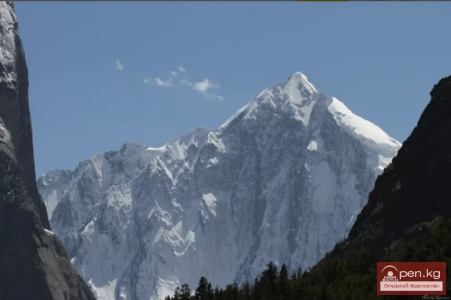
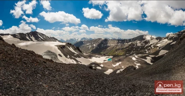
Dzhangart Ridge The Dzhangart mountain ridge is located south of the Kainy Ridge on the border with the People's Republic of China. Administratively, it belongs to the Aksuysky district of the Issyk-Kul region. The small Dzhangart ridge is separated from the Kokshaaltau Ridge by the Dzhangart River and glacier. Ascents are possible both on the Dzhangart ridge, where heights reach up to 4600 meters above sea level, and in the Kokshaaltau Ridge, where heights are 5340 meters above sea
Tursunova Saltanat Askarovna (1952), Doctor of Economic Sciences (1997), Professor (2001) Kyrgyzstan. Born in the city of Osh, Osh region.
Tursunov Askar (1928), Doctor of Philological Sciences (1992), Corresponding Member of the National Academy of Sciences of the Kyrgyz Republic (2000) Kyrgyz. Born in the village of Kegety, Chui region.

Kainy Between Kokshaal-Tau and Kainy-Katta lies the powerful Kuyakap Glacier, and between Kainy-Katta and Inylchek-Tau lies the enormous Kainy Glacier, the younger sibling of Inylchek, the second largest glacier in the region. The glacier is located on the southwestern edge of the Kan-Tenir ridge. It is bordered to the north by the Enilchek-Tuu ridge and to the south by the Kainy ridge of the same name. The length of the glacier is 25.8 kilometers, and its area is 107.5 square kilometers, of
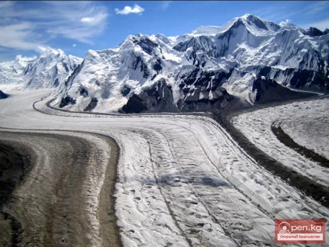
South Inylchek "Inylchek" in Old Turkic means "little prince." But the "prince" turned out to be quite large. The Inylchek glacier is divided into North and South. So, South Inylchek is the largest glacier in the Tien Shan and the second largest mountain glacier in the CIS countries after the Fedchenko glacier in the Pamirs. Its length is slightly less than that of the colossal glaciers of the Karakoram, such as Siachen, Biafo, Baltoro, and Batura. It is located

Meridional Ridge The main nodal uplift of the Central Tien Shan on the border of Kyrgyzstan and China is the Meridional Ridge, approximately 90 km long and with an average height of over 6000 m. The northern continuation of the ridge is the Kakshaal-Too. The highest peaks include Peak Friendship (up to 6800 m), in the Akatau range - Peak High (up to 6964 m), and Peak Military Topographers (up to 6873 m), as well as Bezimenniy (6814 m) and Marble Wall (6140 m), located at the intersection of
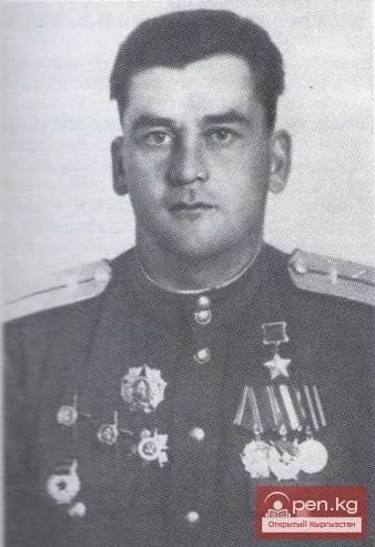
Hero of the Soviet Union Gavrish Ivan Fomich Commander of a flight in the 74th Guards Stalingrad Assault Aviation Regiment (1st Guards Stalingrad Assault Aviation Division, 1st Air Army, 3rd Belorussian Front), Guards Senior Lieutenant. Born on April 7, 1920, in the village of Sadovoe, now part of the Moscow District of Chui Region in the Republic of Kyrgyzstan, in a peasant family. Ukrainian. Graduated from incomplete secondary school. Lived in the city of Frunze (Bishkek). Worked as a helper
Tursunaliev Turdaly (1936), Candidate of Pedagogical Sciences (1968), Professor (1993) Kyrgyz. Born in the village of Kazybek, At-Bashinsky District, Naryn Region.
Turovsky Sergey Dmitrievich (1920-1980), Doctor of Geological and Mineralogical Sciences (1966), Professor (1966) Russian. Born in the city of Michurinsk.

Fergana Ridge A mountain range in the Tien Shan that stretches from southeast to northwest, separating the cold high-altitude plateaus of central Tien Shan from the scorching plains of the Fergana Valley. The length of the ridge is 225 km. Its width is 62 km. The average height (above sea level) is 3620 m. The highest peak, Kara-Kuldja (Uch-Seyit), reaches 4940 m. In the southeastern part, there are about 400 glaciers with a total area of about 195 km². The area in the southern part of the
Turkmenov Mambet Turkmenovich (1928-...), Doctor of Medical Sciences (1978) Kyrgyz. Born in the village of Toktogul, Toktogul District, Osh Region.
Turdukulov Eshaly (1945), Doctor of Biological Sciences (1998) Kyrgyz. Born in the village of Jai-Bolent, Jangi-Jol District, Osh Region.
Turkestan Range A high mountain range oriented in a latitudinal direction, approximately 340 km long and up to 30 km wide, belonging to the Gissar-Alai mountain system. The average height (above sea level) is 4430 m. The highest peaks are Skalistyy (5621 m) and Pyramid Peak (5509 m). Through the Matcha mountain knot, the range connects with the Alai Range to the east and stretches to the Samarkand Plain to the west. The northern slope is long and gentle, with juniper forests and sparse
Turdukulov Asker Turdukulovich (1936), Doctor of Geological and Mineralogical Sciences (1984), Corresponding Member of the National Academy of Sciences of the Kyrgyz Republic (1993), Professor (2001) Kyrgyz. Born in the village of Orto-Suu, Jayil District, Chui Region.
Turdakov Fedor Alekseevich (1899-1968), Doctor of Biological Sciences (1948), Professor (1948), Corresponding Member of the Academy of Sciences of the Kirghiz SSR (1960) Russian. Born in the village of Soldatskoye in Mordovia.
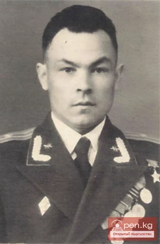
Hero of the Soviet Union Grigory Isayevich Vygлазов Grigory Isayevich Vygлазov was born in 1919 in the village of Shaydarovo, Suzunsky District, Novosibirsk Oblast, into a peasant family. He was Russian and a Komsomol member. He moved with his family to Kyrgyzstan, to the village of Gulcha in the Aksy District of Osh Oblast. He was drafted into the Soviet Army in 1939. He served as a private and a squad commander in a parachute battalion. During the Great Patriotic War, he distinguished

Terskey Alatau The Terskey Alatau Ridge is very beautiful in its variety of landscapes. In one day, you can see the beauty of red sandstone cliffs, wild forests, and snowy peaks, widely spread over the greatest lake, Issyk-Kul. Each gorge is unique and unparalleled in its execution. The Terskey Alatau Ridge ("colorful mountains turned away from the sun") is located latitudinally and frames the basin of Lake Issyk-Kul from the south. The length of the ridge is about 375 km, and in the

Talassky Ala-Too A mountain range located in the Western Tien Shan system. Most of it is situated in Kyrgyzstan, with a part in southern Kazakhstan. This range separates the Talas Valley from other ranges and valleys of the Western Tien Shan and the western part of the so-called Inner Tien Shan. The length of Talassky Ala-Too is about 270 km, with a width of 40 km. The average height (above sea level) is 3930 m, with the highest peak being 4488 m – Mount Manas. The Talas basin is bounded to
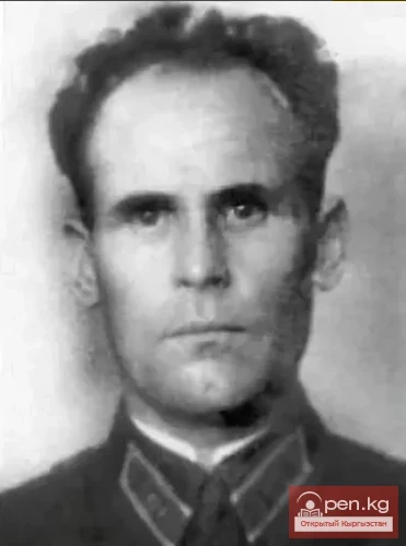
Hero of the Soviet Union Volkovenko Afanasy Ivanovich Afanasy Ivanovich Volkovenko was born in 1907 in the village of Pokrovka, Loktevskaya volost, Zmeinogorsk district of Tomsk province, into a peasant family of poor farmers. He was Ukrainian. In the autumn of 1928, Afanasy Volkovenko was drafted into active military service, after which in 1931 he moved to the city of Frunze and worked in an administrative and economic position in the "Konditer" cooperative. In late July 1941, he
Turgunbekov Rafik (1928-1999), Doctor of Law (1976), Professor (1995), Corresponding Member of the National Academy of Sciences of the Kyrgyz Republic (1993) Kyrgyz. Born in the village of Kum-Aryk, Panfilov District, Chui Region.
Turgumbaev Zhecishbek Jumadylovich (1950), Doctor of Technical Sciences (1992), Professor (1994) Kyrgyz. Born in the village of Ak-Chiy, Kara-Buura District, Talas Region.
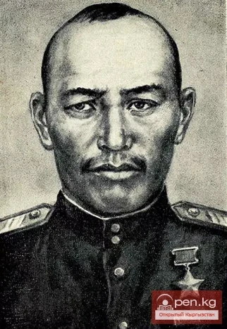
Hero of the Soviet Union Vonakhun Mansuz Mansuz Vonakhun was born in 1907 in the village of Milyanfan in the Kant district of the Kyrgyz SSR. He was Dungan. A member of the Communist Party of the Soviet Union. His civilian profession was a cook. He was drafted into the Soviet Army in December 1942. Sergeant. Commander of a mortar crew. During the Great Patriotic War, he fought on the Central Front in the Kursk area. It was in the gigantic battle on the Oryol-Kursk bulge that he demonstrated

Son-Kul-Tau A mountain range in the Tian Shan, in the southeastern part of Kyrgyzstan. It arches around the northern edge of the Son-Kul lake basin. The length of the ridge is about 60 km, with a maximum height of 3856 m. It is primarily composed of limestone. Alpine meadows are located on the northern slope and in the summit area of the ridge, while subalpine meadow-steppes and steppes are found on the southern side. Susamyr-Tau A mountain range in Kyrgyzstan, part of the Inner Tian Shan

Sarydjaz The mighty snow-covered barrier of the Sarydjaz mountain range rises in the Central Tian Shan, on the territory of Kyrgyzstan and partially Kazakhstan. It is located between the Sarydjaz River to the north and its left tributary, the Inylchek River, to the south. The length of the ridge is 113 km, with a width of up to 16 km. Its peaks rise above 5000 m. The average height is 4370 m, with the highest point being Semenov Peak (5816 m). The ridge is composed of metamorphic schists,

Naryn-Tau The area is hard to access and rarely visited. Due to the low glaciation and modest heights, the Naryn-Tuu ridge has only been traversed by watermen, one hiking group (Svitanko-1963), and, strangely enough, cyclists. The mountain range in the Inner Tien Shan in Kyrgyzstan forms the left bank of the valley of the Great Naryn River. To the east, it is bounded by the Karakolka River - a left tributary of the Naryn. From there, the ridge stretches westward for about 120 km to the
Tulobaev Askarbek Zarlykovich (1959), Doctor of Veterinary Sciences (2000), Professor (2000) Kyrgyz. Born in the village of Ton, Ton District, Issyk-Kul Region.
Tulemyshev Mels Shamyraievich (1939), Doctor of Technical Sciences (1995), Professor (1992) Kyrgyz. Born in Frunze.
Tulekeyev Toktogazy Moldalievich (1951), Doctor of Medical Sciences (1995), Professor (1997) Kyrgyz. Born in the village of Cholpon, Kochkor District, Naryn Region.
Tulokabyloff Mukash (1931-1993), Candidate of Philological Sciences (1965), Professor (1993) Kyrgyz. Born in the village of Korumdu, Issyk-Kul District, Issyk-Kul Region.
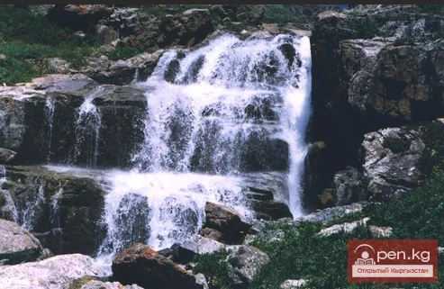
Bright and Colorful Ak-Sai. The height of the waterfall is 25-30 m (2700 m above sea level). Chui region, Ak-Sai gorge. Right tributary of Ala-Archa (2100 m above sea level). Translation from Kyrgyz: ak – white, sai - river. The Ak-Sai waterfall is the most visited attraction of the Ala-Archa National Park. The waterfall is located just 42 km from Bishkek in the extraordinarily beautiful Ala-Archa gorge within the namesake park. From here, a beautiful panorama opens up to the snowy peaks and
Hero of the Soviet Union Belyandra Vasily Yakovlevich Vasily Yakovlevich Belyandra was born in 1914 in the village of Dosovskoye, Kutubuksky District, Kostanay Region. At the age of sixteen, he moved with his parents to Kyrgyzstan, to the village of Buruldai in the Kemin District. He was Russian. He worked as a blacksmith and later as a combine harvester operator in a collective farm. In August 1941, he was drafted into the Soviet Army. His biography began in the harsh defensive battles on the
Moldotau A mountain range in the Inner Tian Shan, in the central part of Kyrgyzstan, south of Lake Son-Kul. The range stretches generally from west to east, between the valleys of the Kökömeren and Naryn rivers. The length of the ridge is about 150 km. The maximum height is 4185 m. It is mainly composed of limestone. The lower slopes are covered with mountain steppes and meadows, while higher up there are areas of spruce forests and juniper groves.

Kungey-Alatau To the south of the Zailiysky Alatau, beyond the deep longitudinal valleys of the Chilik and B. Kemin (Chon-Kemin) rivers, stretches a chain of snowy peaks of the Kungey-Alatau ridge, which borders Lake Issyk-Kul from the north (the Terkey Alatau ridge limits this basin from the south). Together with the Zailiysky Alatau, it forms the Northern Tien Shan. The ridge is elongated in a latitudinal direction (from west to east) and has a length of 275 km in a straight line.

Kuylytau A mountain range in the Central Tien Shan, in Kyrgyzstan. It is located between the rivers Kuyly and Uchkel (the Sarydjaz basin). The length of the ridge is about 50 km, and the maximum height is 5203 m. The ridge is composed of limestones, metamorphic schists, and granites. The Kuyly massif extends approximately 50 km in the latitudinal direction and 25 km in the meridional direction. The natural boundaries of the area are the rivers Sary-Djaz, Uch-Kel, Sarychat, Kuyly, and the Kuyly
Tuzov Leonid Vasilievich (1925), Doctor of Physical and Mathematical Sciences (1967), Professor (1968) Russian. Born in the village of Pendelka, Kuznetsky District, Penza Region, Russia.
Trofimov Mikhail Ivanovich (1929), Doctor of Philological Sciences (1992), Professor (1993) Russian. Born in Moscow, Russian Federation.
Toktosunov Asan Toktosunovich (1930), Doctor of Biological Sciences (1973), Professor (1975), Corresponding Member of the National Academy of Sciences of the Kyrgyz Republic (2000) Kyrgyz. Born in the village of Ak-Beshim, Chui region. Graduated from KSU (1952), postgraduate studies at the Institute of Zoology and Parasitology of the Kyrgyz Branch of the USSR Academy of Sciences (1955).
Toktosopiev Alymbai Moldokmatovich (1953), Doctor of Physical and Mathematical Sciences (1999), Professor (2000) Kyrgyz. Born in the village of Chon-Uryukty, Issyk-Kul District, Issyk-Kul Region.
Koksu Ridge Located in the Western Tien Shan, on the border of Kyrgyzstan and Uzbekistan. Its length is about 70 km, with average heights around 2000 m. It bounds the valley from the southeast, through which the Koksu River flows into the Charvak Reservoir. Here is how V.N. Popov describes the Koksu Ridge in his book: "Western Tien Shan".
Kyrgyz Mountain Ridge A mountain range that borders the Chuy Valley and the Moyunkum Desert to the south. It is located 40-60 km south of the capital of Kyrgyzstan. It is situated in the northwestern part of the Tien Shan within Kyrgyzstan and partially in Kazakhstan. The range extends 400 km from west to east - from the city of Jambyl to the Boom Gorge of the Chu River. In the northern part, it connects with the Talas Ridge, and through a watershed saddle of the Karakol West and Karakol East
Toktoraliev Biymyrza Aitieviich (1951), Doctor of Biological Sciences (1993), Professor (1995), Corresponding Member of the National Academy of Sciences of the Kyrgyz Republic (1997) Kyrgyz. Born in the village of Zhatcy-Bazar, Chatkal District, Jalal-Abad Region.
Toktomyshev Sovetbek Zhaylobekovich (1943), Doctor of Technical Sciences (1983), Professor (1983), Academician of the National Academy of Sciences of the Kyrgyz Republic (1997) Kyrgyz. Born in the village of Predtechanka, Moscow District.

Toktomushev Asanbek (1948), Doctor of Medical Sciences (2000) Kyrgyz. Born in the village of Tash-Bashat, Debelu, in the Naryn region.
Toktomatov Talant Aselievich (1951), Doctor of Chemical Sciences (1995) Kyrgyz. Born in Frunze.
"Barskoon" Barskoon is the name of a village located on the shores of Lake Issyk-Kul. The elders say that a long time ago, a Russian man named Boris settled on the shore of the lake. He built a house, planted a garden, and started growing various fruits and vegetables: tomatoes, potatoes, melons, and watermelons. This was an unprecedented, new phenomenon in this area. After some time, a Kyrgyz family settled nearby. The head of this family had never seen the fruits that grew in